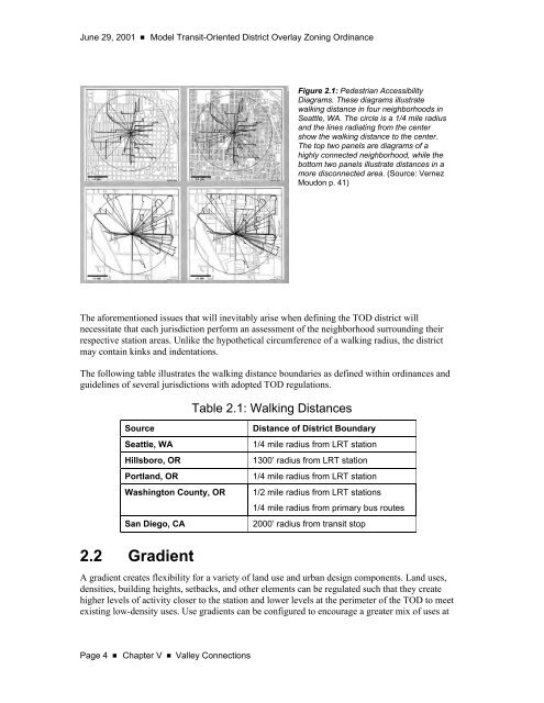
June 29, 2001 ■<strong>Model</strong> Transit-Oriented District Overlay <strong>Zoning</strong> <strong>Ordinance</strong>Figure 2.1: Pedestrian AccessibilityDiagrams. These diagrams illustratewalking distance in four neighborhoods inSeattle, WA. The circle is a 1/4 mile radiusand the lines radiating from the centershow the walking distance to the center.The top two panels are diagrams of ahighly connected neighborhood, while thebottom two panels illustrate distances in amore disconnected area. (Source: VernezMoudon p. 41)The aforementioned issues that will inevitably arise when defining the <strong>TOD</strong> district willnecessitate that each jurisdiction perform an assessment of the neighborhood surrounding theirrespective station areas. Unlike the hypothetical circumference of a walking radius, the districtmay contain kinks and indentations.The following table illustrates the walking distance boundaries as defined within ordinances andguidelines of several jurisdictions with adopted <strong>TOD</strong> regulations.Table 2.1: Walking DistancesSourceSeattle, WAHillsboro, ORPortland, ORWashington County, ORSan Diego, CADistance of District Boundary1/4 mile radius from LRT station1300’ radius from LRT station1/4 mile radius from LRT station1/2 mile radius from LRT stations1/4 mile radius from primary bus routes2000’ radius from transit stop2.2 GradientA gradient creates flexibility for a variety of land use and urban design components. Land uses,densities, building heights, setbacks, and other elements can be regulated such that they createhigher levels of activity closer to the station and lower levels at the perimeter of the <strong>TOD</strong> to meetexisting low-density uses. Use gradients can be configured to encourage a greater mix of uses atPage 4 ■Chapter V ■ Valley Connections
<strong>Model</strong> Transit-Oriented District Overlay <strong>Zoning</strong> <strong>Ordinance</strong> ■ June 29, 2001the center and then transition to a single use that reflects the predominant use in the areasurrounding the <strong>TOD</strong>. For example, uses should transition to residential buildings of similarcharacter to a surrounding single-family neighborhood.Gradients can also vary within the <strong>TOD</strong> where circumstances call for greater sensitivity toexisting uses. Building heights may vary within the <strong>TOD</strong> to reflect existing building heightvariations. In other words, areas closer to the station will generally cater more to the pedestrianand less to the automobile and can be higher densities, a finer grain of detail, and a greater mix ofuses.3. Permitted UsesDevelopment must create an appropriate mix of complementary uses to be economicallysustainable and successful. This is particularly important for Transit-Oriented Development as itssuccess or failure will also affect transit ridership, pedestrian activity, and the future of otherstation area efforts. To complicate matters, most of the stations along the Central Phoenix/EastValley (CP/EV) light rail corridor will be located within established communities, where overtime, existing regulations have permitted some uses that are not compatible with <strong>TOD</strong> principles.During the station area planning process, individual municipalities should review their zoningordinances for possible obstacles to creating Transit-Oriented Development. At a minimum, aninterim overlay should serve to prohibit incompatible uses from developing in the station areabefore a rezone can be completed. Consequently, landowners and developers should be givenalternatives to prevent a scenario where no development occurs or it occurs in a manner thatmeets <strong>TOD</strong> principles in letter, but not in spirit.For this reason, it is equally important that the overlay encourages development that is conduciveto creating a transit- and pedestrian-friendly environment and that guidelines and regulationscreate a pedestrian-friendly urban character. Alternatives can give property owners options todevelop their parcels and prevent a no-growth scenario from occurring.Almost any urban or suburban land use is appropriate within a <strong>TOD</strong>, the exceptions being usesthat are noxious or otherwise unsafe, and those that do not support pedestrian activity, eitherbecause of the low intensity nature of their use (their required building form or siting) or that theyare dominated by automobile activity. Uses with these characteristics have been listed in theProhibited Uses section. Emphasis for permitted uses is placed on configuration, program, anddesign. An office campus in a suburban area will typically consist of low-rise buildings with therequisite sea of parking and little variety in uses, forcing workers to drive for lunch or errands.However, an office campus could easily fit into a <strong>TOD</strong> if configured, permitted, and designed insuch a way that it creates a fairly dense and walkable environment. On the other hand, a bulkfacility requires that customers take their goods home via a car necessitating ample parking. Byits very essence, such a use cannot be configured to accommodate pedestrian activity.Valley Connections ■ Chapter V ■ Page 5
- Page 4 and 5:
June 29, 2001 ■Model Transit-Orie
- Page 6 and 7:
June 29, 2001 ■Model Transit-Orie
- Page 8 and 9:
June 29, 2001 ■Model Transit-Orie
- Page 10 and 11:
June 29, 2001 ■ Model Transit-Ori
- Page 12 and 13:
June 29, 2001 ■ Model Transit-Ori
- Page 14 and 15:
June 29, 2001 ■ Model Transit-Ori
- Page 16 and 17:
June 29, 2001 ■ Model Transit-Ori
- Page 18 and 19:
June 29, 2001 ■ Model Transit-Ori
- Page 20 and 21:
June 29, 2001 ν Model Transit-Orie
- Page 22 and 23:
June 29, 2001 ■ Model Transit-Ori
- Page 24 and 25:
June 29, 2001 ■Model Transit-Orie
- Page 26 and 27:
June 29, 2001 ■Model Transit-Orie
- Page 28 and 29:
June 29, 2001 ■Model Transit-Orie
- Page 30 and 31: June 29, 2001 ■Model Transit-Orie
- Page 32 and 33: June 29, 2001 ■Model Transit-Orie
- Page 34 and 35: June 29, 2001 ■Model Transit-Orie
- Page 36 and 37: June 29, 2001 ■Model Transit-Orie
- Page 38 and 39: June 29, 2001 ■Model Transit-Orie
- Page 40 and 41: June 29, 2001 ■Model Transit-Orie
- Page 42 and 43: June 29, 2001 ■Model Transit-Orie
- Page 44 and 45: June 29, 2001 ■Model Transit-Orie
- Page 46 and 47: June 29, 2001 ■Model Transit-Orie
- Page 48 and 49: June 29, 2001 ■Model Transit-Orie
- Page 50 and 51: June 29, 2001 ■Model Transit-Orie
- Page 52 and 53: June 29, 2001 ■Model Transit-Orie
- Page 54 and 55: June 29, 2001 ■Model Transit-Orie
- Page 57 and 58: Model Transit-Oriented District Ove
- Page 59 and 60: Model Transit-Oriented District Ove
- Page 61 and 62: Model Transit-Oriented District Ove
- Page 63 and 64: Model Transit-Oriented District Ove
- Page 65 and 66: Model Transit-Oriented District Ove
- Page 67 and 68: Model Transit-Oriented District Ove
- Page 69 and 70: Model Transit-Oriented District Ove
- Page 71 and 72: Model Transit-Oriented District Ove
- Page 73 and 74: Model Transit-Oriented District Ove
- Page 75: Model Transit-Oriented District Ove
- Page 78 and 79: June 29, 2001 ■Model Transit-Orie
- Page 82 and 83: June 29, 2001 ■Model Transit-Orie
- Page 84 and 85: June 29, 2001 ■Model Transit-Orie
- Page 86 and 87: June 29, 2001 ■Model Transit-Orie
- Page 88 and 89: June 29, 2001 ■Model Transit-Orie
- Page 90 and 91: June 29, 2001 ■Model Transit-Orie
- Page 92 and 93: June 29, 2001 ■Model Transit-Orie
- Page 94 and 95: June 29, 2001 ■Model Transit-Orie
- Page 96 and 97: June 29, 2001 ■Model Transit-Orie
- Page 98 and 99: June 29, 2001 ■Model Transit-Orie
- Page 100 and 101: June 29, 2001 ■Model Transit-Orie
- Page 102 and 103: June 29, 2001 ■Model Transit-Orie
- Page 105 and 106: Model Transit-Oriented District Ove
- Page 107 and 108: Model Transit-Oriented District Ove
- Page 109 and 110: Model Transit-Oriented District Ove
- Page 111 and 112: Model Transit-Oriented District Ove
- Page 113 and 114: Model Transit-Oriented District Ove
- Page 115 and 116: Model Transit-Oriented District Ove
- Page 117 and 118: Model Transit-Oriented District Ove
- Page 119 and 120: Model Transit-Oriented District Ove
- Page 121 and 122: Model Transit-Oriented District Ove
- Page 123 and 124: Model Transit-Oriented District Ove
- Page 125 and 126: Model Transit-Oriented District Ove
- Page 127 and 128: Model Transit-Oriented District Ove
- Page 129 and 130: Model Transit-Oriented District Ove
- Page 131 and 132:
Model Transit-Oriented District Ove
- Page 133 and 134:
Model Transit-Oriented District Ove
- Page 135 and 136:
Model Transit-Oriented District Ove
- Page 137 and 138:
Model Transit-Oriented District Ove
- Page 139 and 140:
Model Transit-Oriented District Ove
- Page 141 and 142:
Model Transit-Oriented District Ove
- Page 143 and 144:
Model Transit-Oriented District Ove
- Page 145 and 146:
Model Transit-Oriented District Ove
- Page 147 and 148:
Model Transit-Oriented District Ove
- Page 149 and 150:
Model Transit-Oriented District Ove
- Page 151:
Model Transit-Oriented District Ove