Data Acquisition and Processing Report (DAPR) - Center for Coastal ...
Data Acquisition and Processing Report (DAPR) - Center for Coastal ...
Data Acquisition and Processing Report (DAPR) - Center for Coastal ...

You also want an ePaper? Increase the reach of your titles
YUMPU automatically turns print PDFs into web optimized ePapers that Google loves.
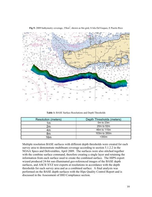
Fig 5: 2009 bathymetry coverage, 35km 2 , shown as 8m grid, S Isla DeVieques, E Puerto Rico<br />
Table 1: BASE Surface Resolutions <strong>and</strong> Depth Thresholds<br />
Resolution (meters) Depth Thresholds (meters)<br />
1m<br />
0m to 23m<br />
2m<br />
20m to 52m<br />
4m<br />
46m to 115m<br />
8m<br />
103m to 350m<br />
16m<br />
+350m<br />
Multiple resolution BASE surfaces with different depth thresholds were created <strong>for</strong> each<br />
survey area to demonstrate multibeam coverage according to section 5.1.2.2 in the<br />
NOAA Specs <strong>and</strong> Deliverables, April 2009. The surfaces were also stitched together<br />
with the combine surface comm<strong>and</strong>, there<strong>for</strong>e creating a single layer <strong>and</strong> retaining the<br />
in<strong>for</strong>mation from each surface used to create the combined surface. The HIPS export<br />
wizard produced 24-bit sun-illuminated geo-referenced images of the BASE depth<br />
surfaces, <strong>and</strong> ASCII XYZ text exports at resolutions in accordance with the depth<br />
thresholds <strong>for</strong> each survey area <strong>and</strong> as a combined surface. A final analysis was<br />
per<strong>for</strong>med on the BASE depth surfaces with the Hips Quality Control <strong>Report</strong> <strong>and</strong> is<br />
discussed in the Assessment of IHO Compliance section.<br />
10