Data Acquisition and Processing Report (DAPR) - Center for Coastal ...
Data Acquisition and Processing Report (DAPR) - Center for Coastal ...
Data Acquisition and Processing Report (DAPR) - Center for Coastal ...

Create successful ePaper yourself
Turn your PDF publications into a flip-book with our unique Google optimized e-Paper software.
I. Background<br />
In June 1998, the U.S. Coral Reef Task Force (USCRTF) was established by<br />
Presidential Executive Order 13089. The USCRTF mission is to lead, coordinate, <strong>and</strong><br />
strengthen U.S. government actions to better preserve <strong>and</strong> protect coral reef ecosystems.<br />
The National Oceanic <strong>and</strong> Atmospheric Administration’s (NOAA) <strong>Center</strong> <strong>for</strong> <strong>Coastal</strong><br />
Monitoring <strong>and</strong> Assessment (CCMA) Biogeography Team is supporting the USCRTF<br />
m<strong>and</strong>ate. The Biogeography Team completed its sixth year of an ongoing scientific<br />
research mission on board the NOAA Ship NANCY FOSTER from March 26 to April 2,<br />
2009. The objective of this project was to collect a multibeam bathymetry dataset with<br />
100% seafloor ensonification, along with multibeam backscatter suitable <strong>for</strong> seafloor<br />
characterization in high priority conservation areas within Puerto Rico. Scientists<br />
collected high-resolution multibeam in mid-water depths from approximately 10 to 1020<br />
meters. The multibeam data was collected to con<strong>for</strong>m to IHO Order 1 (100m) accuracy st<strong>and</strong>ards. The strategies developed <strong>for</strong> each survey area took<br />
into account the minimum depths, general bathymetry, <strong>and</strong> time allotment. The<br />
delineation <strong>and</strong> identification of seafloor habitats within areas mapped during the mission<br />
was assisted by the use of an ROV with video <strong>and</strong> camera capabilities.<br />
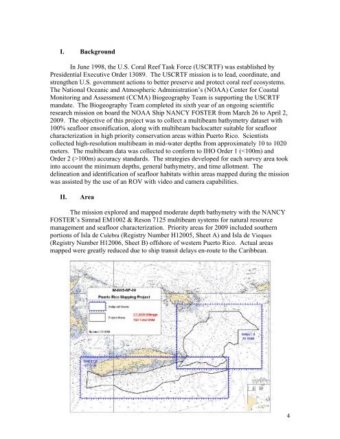
II. Area<br />
The mission explored <strong>and</strong> mapped moderate depth bathymetry with the NANCY<br />
FOSTER’s Simrad EM1002 & Reson 7125 multibeam systems <strong>for</strong> natural resource<br />
management <strong>and</strong> seafloor characterization. Priority areas <strong>for</strong> 2009 included southern<br />
portions of Isla de Culebra (Registry Number H12005, Sheet A) <strong>and</strong> Isla de Vieques<br />
(Registry Number H12006, Sheet B) offshore of western Puerto Rico. Actual areas<br />
mapped were greatly reduced due to ship transit delays en-route to the Caribbean.<br />
4