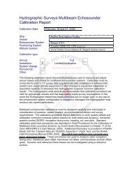
Data Acquisition and Processing Report (DAPR) - Center for Coastal ...
Data Acquisition and Processing Report (DAPR) - Center for Coastal ...
Data Acquisition and Processing Report (DAPR) - Center for Coastal ...

You also want an ePaper? Increase the reach of your titles
YUMPU automatically turns print PDFs into web optimized ePapers that Google loves.
This section is not applicable <strong>for</strong> this project.<br />
1.3.3. Benchmark Recovery <strong>and</strong> GPS Requirements<br />
This section is not applicable <strong>for</strong> this project.<br />
1.3.4. This section is not applicable <strong>for</strong> this project.<br />
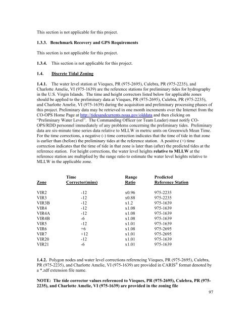
1.4. Discrete Tidal Zoning<br />
1.4.1. The water level station at Vieques, PR (975-2695), Culebra, PR (975-2235), <strong>and</strong><br />
Charlotte Amelie, VI (975-1639) are the reference stations <strong>for</strong> preliminary tides <strong>for</strong> hydrography<br />
in the U.S. Virgin Isl<strong>and</strong>s. The time <strong>and</strong> height correctors listed below <strong>for</strong> applicable zones<br />
should be applied to the preliminary data at Vieques, PR (975-2695), Culebra, PR (975-2235),<br />
<strong>and</strong> Charlotte Amelie, VI (975-1639) during the acquisition <strong>and</strong> preliminary processing phases of<br />
this project. Preliminary data may be retrieved in one month increments over the Internet from the<br />
CO-OPS Home Page at http://tides<strong>and</strong>currents.noaa.gov/olddata <strong>and</strong> then clicking on<br />
“Preliminary Water Level”. The Comm<strong>and</strong>ing Officer (or Team Leader) must notify CO-<br />
OPS/RDD personnel immediately of any problems concerning the preliminary tides. Preliminary<br />
data are six-minute time series data relative to MLLW in metric units on Greenwich Mean Time.<br />
For the time corrections, a negative (-) time correction indicates that the time of tide in that zone<br />
is earlier than (be<strong>for</strong>e) the preliminary tides at the reference station. A positive (+) time<br />
correction indicates that the time of tide in that zone is later than (after) the predicted tides at the<br />
reference station. For height corrections, the water level heights relative to MLLW at the<br />
reference station are multiplied by the range ratio to estimate the water level heights relative to<br />
MLLW in the applicable zone.<br />
Time Range Predicted<br />
Zone Corrector(mins) Ratio Reference Station<br />
VIR2 -12 x0.96 975-2235<br />
VIR3 -12 x0.88 975-2235<br />
VIR3B -12 x1.2 975-1639<br />
VIR4 -12 x1.08 975-1639<br />
VIR4A -12 x1.08 975-1639<br />
VIR4B -6 x1.08 975-1639<br />
VIR5 -12 x1.01 975-1639<br />
VIR6 +6 x1.08 975-2695<br />
VIR7 +12 x1.01 975-2695<br />
VIR20 -12 x1.01 975-1639<br />
VIR21 -6 x1.01 975-1639<br />
1.4.2. Polygon nodes <strong>and</strong> water level corrections referencing Vieques, PR (975-2695), Culebra,<br />
PR (975-2235), <strong>and</strong> Charlotte Amelie, VI (975-1639) are provided in CARIS ® <strong>for</strong>mat denoted by<br />
a *.zdf extension file name.<br />
NOTE: The tide corrector values referenced to Vieques, PR (975-2695), Culebra, PR (975-<br />
2235), <strong>and</strong> Charlotte Amelie, VI (975-1639) are provided in the zoning file<br />
97