Data Acquisition and Processing Report (DAPR) - Center for Coastal ...
Data Acquisition and Processing Report (DAPR) - Center for Coastal ...
Data Acquisition and Processing Report (DAPR) - Center for Coastal ...

You also want an ePaper? Increase the reach of your titles
YUMPU automatically turns print PDFs into web optimized ePapers that Google loves.
emoved remaining fliers, as well as down-sloping beams where the survey lines crossed<br />
over the reef escarpment providing unreliable soundings.<br />
The Hips Subset Editor <strong>and</strong> BASE surface creation were the second phase of<br />
editing. Subset editing enabled the hydrographer to evaluate each swath against its<br />
neighboring swath while identifying potential tidal <strong>and</strong> motion artifacts. The verification<br />
<strong>and</strong> alignment of features from adjacent lines also confirmed sensor offsets. BASE<br />
surfaces were created to illustrate adequate sonar coverage <strong>and</strong> to also identify systematic<br />
errors or artifacts within the data set. The Bathymetry Associated with Statistical Error<br />
(BASE) surfaces created from the merged <strong>and</strong> TPE calculated soundings are georeferenced<br />
images of a weighted mean surface. The BASE surface uses a combination of<br />
range, uncertainty <strong>and</strong> swath angle weights to assign nodes depth values to create an<br />
image of the seabed surface. The BASE surface images were reviewed with multiple<br />
resolutions, sun angles, sun azimuths <strong>and</strong> vertical exaggerations. The BASE surface<br />
routine produced images representing depth, shoal-biased depth, deep-biased depth, mean<br />
depth, st<strong>and</strong>ard deviation, sounding density, <strong>and</strong> depth uncertainty. During acquisition in<br />
the field editing steps were expedited to create BASE surfaces to confirm adequate<br />
multibeam coverage <strong>for</strong> each survey area <strong>and</strong> to identify ROV transects. The contract<br />
Lead Hydrographer completed final processing of the datasets after field operations. This<br />
included the re-application of sound velocity profiles adjusted by Reson B.V. to try <strong>and</strong><br />
compensate <strong>for</strong> beam steering inaccuracies <strong>and</strong> the application of final tides. Refer to<br />
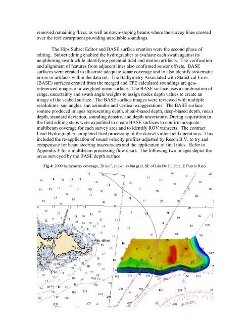
Appendix F <strong>for</strong> a multibeam processing flow chart. The following two images depict the<br />
areas surveyed by the BASE depth surface.<br />
Fig 4: 2009 bathymetry coverage, 20 km 2 , shown as 8m grid, SE of Isla De Culebra, E Puerto Rico.<br />
9