- Page 1 and 2:
4/12/2018 • 4 Rancocas Creek Nati
- Page 3 and 4:
National Water Trails Seven “Pill
- Page 5 and 6:
ef: USGS Landsat 4 Rancocas Creek N
- Page 7 and 8:
Rancocas Creek Chronology Cultural,
- Page 9 and 10:
Rancocas Creek National Water Trail
- Page 11 and 12:
Rancocas Creek National Water Trail
- Page 13 and 14:
a ppreciates an enlightened use Ran
- Page 15 and 16:
It’s a Wonderful Route - Charting
- Page 17 and 18:
Publicize Rancocas Creek Tidewater
- Page 19 and 20:
COALITIONS CAUSE RIPPLES Formal vs.
- Page 21 and 22:
Shared Vision: Rancocas Creek Natio
- Page 23 and 24:
• Federal • State • County
- Page 25 and 26:
Rancocas Creek National Water Trail
- Page 27 and 28:
RCrk National Water Trail Elevates
- Page 29 and 30:
Rediscover - Restore - Recreation P
- Page 31 and 32:
4/12/2018 4 Rancocas Creek National
- Page 33 and 34:
Destination Attributes and Points o
- Page 35 and 36:
Rancocas Creek National Water Trail
- Page 37 and 38:
( 3) - N Branch Headwaters Area Ent
- Page 39 and 40:
B lue Arrows Show Direction of Wate
- Page 41 and 42:
Rancocas The tide ends on the North
- Page 43 and 44:
Rancocas Creek Communities are tied
- Page 45 and 46:
Dutch Trade on the Delaware River w
- Page 47 and 48:
Philadelphia Trading Area 1760 Mt.
- Page 49 and 50:
State of NJ Legislative Navigation
- Page 51 and 52:
West Jersey Rancocas Creek Rail Lin
- Page 53 and 54:
RCNWT Geo-Fact Existing Public Tran
- Page 55 and 56:
North Branch Mt. Holly Branch Ranco
- Page 57 and 58:
N Branch Rancocas Creek Headwaters
- Page 59 and 60:
Rich Soil of NJ’s Marl Region RCN
- Page 61 and 62:
Representative of Distinguished Uni
- Page 63 and 64:
- Joint Base MDL N Branch 4/12/2018
- Page 65 and 66:
Pemberton/New Mills/New Lisbon 4/12
- Page 67 and 68:
Mt. Holly Cuesta 183 Feet Above Sea
- Page 69 and 70:
RCNWT Geo-Fact Mùxulhama “He Who
- Page 71 and 72:
Smithville-Eastampto n-Mt Holly Pho
- Page 73 and 74:
Non- Tidal South Branch South Branc
- Page 75 and 76:
Mt. Misery Area Headwaters of the S
- Page 77 and 78:
S Branch Hydrosaur Dinosaurs, Mosas
- Page 79 and 80:
4/12/2018 4 Rancocas Creek National
- Page 81 and 82:
SW Branch Rancocas Creek Headwater
- Page 83 and 84:
Headwaters of SW Branch Rancocas Wh
- Page 85 and 86:
James Still, (1812- 1885) the Dr. o
- Page 87 and 88:
Down creek Lumberton S and SW Branc
- Page 89 and 90:
Confluence North and South Branch C
- Page 91 and 92: Mt. Holly Police Department 1700’
- Page 93 and 94: 40.00000° N Geo-L ocation : 40.001
- Page 95 and 96: 350000 June - 1909 Partial Value of
- Page 98 and 99: Mt. Holly Oxbow, Mill Race n Flood
- Page 100 and 101: Mill Dam Pool-Mt. Holly H ummingbir
- Page 102 and 103: Clothing and Textile Hub of Manufac
- Page 104 and 105: Low Tide, Mt. Holly Flood Control W
- Page 106 and 107: On the N Branch Downstream Mt. Holl
- Page 108 and 109: N Branch Tidal Timbuctoo Rancocas S
- Page 110 and 111: N Branch 870’s 1 RCNWT Geo-Fact D
- Page 112 and 113: When or the on the N Branch “ Dri
- Page 114 and 115: Semi-Wild Paddling RCNWT Geo-Fact N
- Page 116 and 117: N Branch Historic Timbuctoo 4/12/20
- Page 118 and 119: Little Dipper (“Drinking Gourd”
- Page 120 and 121: R SP - Rancocas State Park RCNWT Ge
- Page 122 and 123: R ancocas Creek Paddlers Alert: 201
- Page 124 and 125: Devonish Range & Landing Taylor’s
- Page 126 and 127: Below the Confluence M ain Stem - R
- Page 128 and 129: 4. 2. 3. 3. 4. 5. Rancocas Creek C
- Page 130 and 131: RCNWT Geo-Fact 4/12/2018
- Page 132 and 133: Rancocas Creek Phosphorous Match Wo
- Page 134 and 135: Moorsetown - Chester Boundary Creek
- Page 136 and 137: Willingboro Mill Creek Thomas Olliv
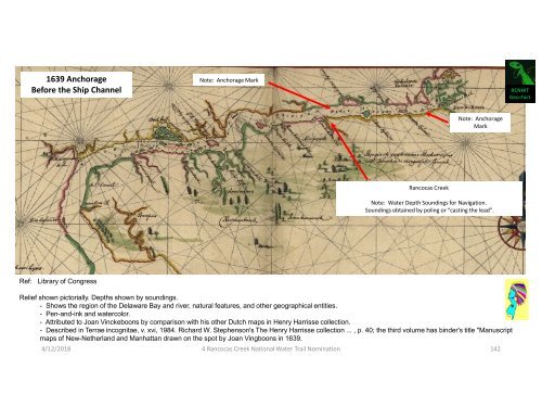
- Page 138 and 139: Delaware River and Rancocas Creek M
- Page 140 and 141: R ancocas Creek - Delaware River Ma
- Page 144 and 145: Riverfront Access PA Tidewater Dela
- Page 146 and 147: 4/12/2018 4 Rancocas Creek National
- Page 148 and 149: 1877 Rancocas Creek Navigation Char
- Page 151 and 152: Rancocas Creek Multi-Use Tide- Wate
- Page 153 and 154: R ancocas Creek and Delaware River
- Page 155 and 156: Delaware River (tidewater) is a uni
- Page 157: Locally, Devonish Regionally, Value