Microsoft PowerPoint - Rancocas Creek National Water Trail master - 4211116

Create successful ePaper yourself
Turn your PDF publications into a flip-book with our unique Google optimized e-Paper software.
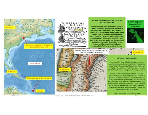
40.00000°<br />
N<br />
Geo-L ocation : 40.00182°<br />
N - 74.81465° E<br />
Mouth of the <strong>Rancocas</strong> <strong>Creek</strong><br />
Mt. Holly and the <strong>Rancocas</strong> <strong>Creek</strong> Sits<br />
40.0000 Degree Line<br />
on the<br />
Bernard Devonish, Land Owner on the <strong>Rancocas</strong><br />
<strong>Creek</strong> in 1687 sailed regularly back and forth to<br />
Barbados from the <strong>Rancocas</strong> <strong>Creek</strong>. Bernard's<br />
brother was a Ship’s Captain known to have sailed<br />
from the Ports of Baltimore and Philadelphia.<br />
Back in the 1700’s brigs and such unloaded cargo<br />
from Barbados in the Port of Philadelphia. From<br />
these docks, cargo was loaded into <strong>Rancocas</strong> <strong>Creek</strong><br />
shallops and than sailed the tide back to the<br />
Devonish and Other Land Holdings (todays<br />
<strong>Rancocas</strong> State Park) up on at the confluence.<br />
RCNWT GEO-FACT<br />
<strong>Rancocas</strong> <strong>Creek</strong><br />
Navigation<br />
Geo-L ocation : 40.00182°<br />
N - 74.81465° E<br />
Mouth of the <strong>Rancocas</strong> <strong>Creek</strong><br />
40.00000°<br />
N<br />
18<br />
th<br />
Century Navigation Plan<br />
20.0000°<br />
N<br />
Horse Latitudes<br />
Geo-L ocation: 13° 10'<br />
N and 59° 32' W<br />
Barbados<br />
40.00000°<br />
N<br />
As an example: General Sailing Directions from the<br />
Island of Barbados to the <strong>Rancocas</strong> <strong>Creek</strong>. Actual plans<br />
vary in detail. The majority of Captains and Pilots kept<br />
knowledge of the trade and maritime passage ---<br />
private.<br />
Word of mouth passed from generations to generations.<br />
Sample Sail Plan: Sail North-<br />
West from Barbados,<br />
striking in two weeks the Coast (America). Sail North to<br />
the South River (Delaware Bay). Ascend the Delaware<br />
River passing the Port of Philadelphia to 40.0000 N. At<br />
the “Hens and Chicks” rocks at “White Sheet Bay” effect<br />
safe passage in to the <strong>Rancocas</strong> <strong>Creek</strong>. Allow the tide to<br />
sail you East on the <strong>Rancocas</strong> <strong>Creek</strong> to the Confluence.<br />
Take the North Fork to Devonish Landing*. Follow the<br />
Little Dipper up creek to Mt. Holly.<br />
(* now inside todays <strong>Rancocas</strong> State Park).<br />
4/12/2018<br />
4 <strong>Rancocas</strong> <strong>Creek</strong> <strong>National</strong> <strong>Water</strong> <strong>Trail</strong> Nomination<br />
93