Gudiyattam Gudiyattam Town - Municipal
Gudiyattam Gudiyattam Town - Municipal
Gudiyattam Gudiyattam Town - Municipal

You also want an ePaper? Increase the reach of your titles
YUMPU automatically turns print PDFs into web optimized ePapers that Google loves.
Chapter ñ3 Final Report: <strong>Gudiyattam</strong> <strong>Municipal</strong>ity<br />
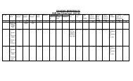
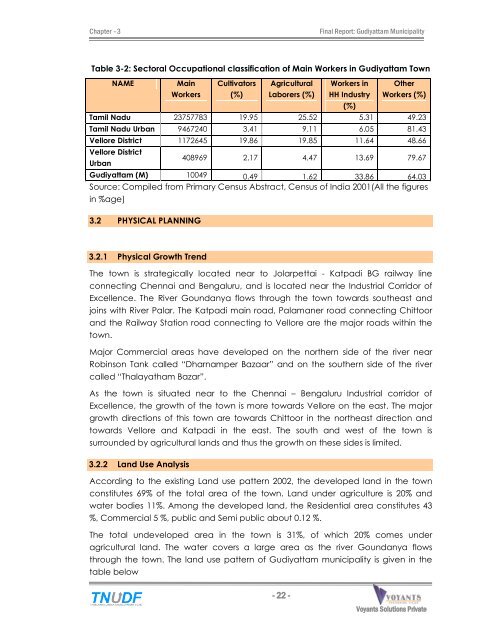
Table 3-2: Sectoral Occupational classification of Main Workers in <strong>Gudiyattam</strong> <strong>Town</strong><br />
NAME Main<br />
Workers<br />
Cultivators<br />
(%)<br />
Agricultural<br />
Laborers (%)<br />
- 22 -<br />
Workers in<br />
HH Industry<br />
(%)<br />
Other<br />
Workers (%)<br />
Tamil Nadu 23757783 19.95 25.52 5.31 49.23<br />
Tamil Nadu Urban 9467240 3.41 9.11 6.05 81.43<br />
Vellore District 1172645 19.86 19.85 11.64 48.66<br />
Vellore District<br />
Urban<br />
408969 2.17 4.47 13.69 79.67<br />
<strong>Gudiyattam</strong> (M) 10049 0.49 1.62 33.86 64.03<br />
Source: Compiled from Primary Census Abstract, Census of India 2001(All the figures<br />
in %age)<br />
3.2 PHYSICAL PLANNING<br />
3.2.1 Physical Growth Trend<br />
The town is strategically located near to Jolarpettai - Katpadi BG railway line<br />
connecting Chennai and Bengaluru, and is located near the Industrial Corridor of<br />
Excellence. The River Goundanya flows through the town towards southeast and<br />
joins with River Palar. The Katpadi main road, Palamaner road connecting Chittoor<br />
and the Railway Station road connecting to Vellore are the major roads within the<br />
town.<br />
Major Commercial areas have developed on the northern side of the river near<br />
Robinson Tank called ìDharnamper Bazaarî and on the southern side of the river<br />
called ìThalayatham Bazarî.<br />
As the town is situated near to the Chennai ñ Bengaluru Industrial corridor of<br />
Excellence, the growth of the town is more towards Vellore on the east. The major<br />
growth directions of this town are towards Chittoor in the northeast direction and<br />
towards Vellore and Katpadi in the east. The south and west of the town is<br />
surrounded by agricultural lands and thus the growth on these sides is limited.<br />
3.2.2 Land Use Analysis<br />
According to the existing Land use pattern 2002, the developed land in the town<br />
constitutes 69% of the total area of the town. Land under agriculture is 20% and<br />
water bodies 11%. Among the developed land, the Residential area constitutes 43<br />
%, Commercial 5 %, public and Semi public about 0.12 %.<br />
The total undeveloped area in the town is 31%, of which 20% comes under<br />
agricultural land. The water covers a large area as the river Goundanya flows<br />
through the town. The land use pattern of <strong>Gudiyattam</strong> municipality is given in the<br />
table below<br />
Voyants Solutions Private<br />
Limited