

Sample A: Cover Page of Thesis, Project, or Dissertation Proposal
Sample A: Cover Page of Thesis, Project, or Dissertation Proposal
Sample A: Cover Page of Thesis, Project, or Dissertation Proposal

Create successful ePaper yourself
Turn your PDF publications into a flip-book with our unique Google optimized e-Paper software.
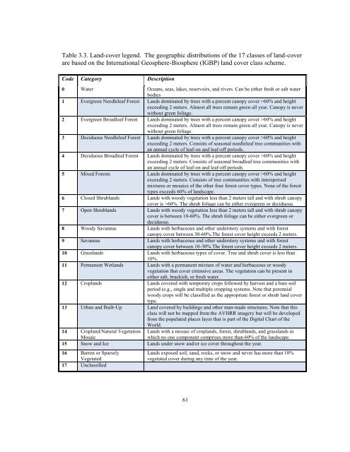
Table 3.3. Land-cover legend. The geographic distributions <strong>of</strong> the 17 classes <strong>of</strong> land-cover<br />
are based on the International Geosphere-Biosphere (IGBP) land cover class scheme.<br />
Code Categ<strong>or</strong>y Description<br />
0 Water Oceans, seas, lakes, reservoirs, and rivers. Can be either fresh <strong>or</strong> salt water<br />
bodies<br />
1 Evergreen Needleleaf F<strong>or</strong>est Lands dominated by trees with a percent canopy cover >60% and height<br />
exceeding 2 meters. Almost all trees remain green all year. Canopy is never<br />
without green foliage.<br />
2 Evergreen Broadleaf F<strong>or</strong>est Lands dominated by trees with a percent canopy cover >60% and height<br />
exceeding 2 meters. Almost all trees remain green all year. Canopy is never<br />
without green foliage.<br />
3 Deciduous Needleleaf F<strong>or</strong>est Lands dominated by trees with a percent canopy cover >60% and height<br />
exceeding 2 meters. Consists <strong>of</strong> seasonal needleleaf tree communities with<br />
an annual cycle <strong>of</strong> leaf-on and leaf-<strong>of</strong>f periods.<br />
4 Deciduous Broadleaf F<strong>or</strong>est Lands dominated by trees with a percent canopy cover >60% and height<br />
exceeding 2 meters. Consists <strong>of</strong> seasonal broadleaf tree communities with<br />
an annual cycle <strong>of</strong> leaf-on and leaf-<strong>of</strong>f periods.<br />
5 Mixed F<strong>or</strong>ests Lands dominated by trees with a percent canopy cover >60% and height<br />
exceeding 2 meters. Consists <strong>of</strong> tree communities with interspersed<br />
mixtures <strong>or</strong> mosaics <strong>of</strong> the other four f<strong>or</strong>est cover types. None <strong>of</strong> the f<strong>or</strong>est<br />
types exceeds 60% <strong>of</strong> landscape.<br />
6 Closed Shrublands Lands with woody vegetation less than 2 meters tall and with shrub canopy<br />
cover is >60%. The shrub foliage can be either evergreen <strong>or</strong> deciduous.<br />
7 Open Shrublands Lands with woody vegetation less than 2 meters tall and with shrub canopy<br />
cover is between 10-60%. The shrub foliage can be either evergreen <strong>or</strong><br />
deciduous.<br />
8 Woody Savannas Lands with herbaceous and other underst<strong>or</strong>y systems and with f<strong>or</strong>est<br />
canopy cover between 30-60%.The f<strong>or</strong>est cover height exceeds 2 meters.<br />
9 Savannas Lands with herbaceous and other underst<strong>or</strong>y systems and with f<strong>or</strong>est<br />
canopy cover between 10-30%.The f<strong>or</strong>est cover height exceeds 2 meters.<br />
10 Grasslands Lands with herbaceous types <strong>of</strong> cover. Tree and shrub cover is less than<br />
10%.<br />
11 Permanent Wetlands Lands with a permanent mixture <strong>of</strong> water and herbaceous <strong>or</strong> woody<br />
vegetation that cover extensive areas. The vegetation can be present in<br />
either salt, brackish, <strong>or</strong> fresh water.<br />
12 Croplands Lands covered with temp<strong>or</strong>ary crops followed by harvest and a bare soil<br />
period (e.g., single and multiple cropping systems. Note that perennial<br />
woody crops will be classified as the appropriate f<strong>or</strong>est <strong>or</strong> shrub land cover<br />
type.<br />
13 Urban and Built-Up Land covered by buildings and other man-made structures. Note that this<br />
class will not be mapped from the AVHRR imagery but will be developed<br />
from the populated places layer that is part <strong>of</strong> the Digital Chart <strong>of</strong> the<br />
W<strong>or</strong>ld.<br />
14 Cropland/Natural Vegetation Lands with a mosaic <strong>of</strong> croplands, f<strong>or</strong>est, shrublands, and grasslands in<br />
Mosaic<br />
which no one component comprises m<strong>or</strong>e than 60% <strong>of</strong> the landscape.<br />
15 Snow and Ice Lands under snow and/<strong>or</strong> ice cover throughout the year.<br />
16 Barren <strong>or</strong> Sparsely<br />
Vegetated<br />
17 Unclassified<br />
Lands exposed soil, sand, rocks, <strong>or</strong> snow and never has m<strong>or</strong>e than 10%<br />
vegetated cover during any time <strong>of</strong> the year.<br />
61
![[Sample B: Approval/Signature Sheet] - George Mason University](https://img.yumpu.com/21978828/1/190x245/sample-b-approval-signature-sheet-george-mason-university.jpg?quality=85)
![[Sample B: Approval/Signature Sheet] - George Mason University](https://img.yumpu.com/18694905/1/190x245/sample-b-approval-signature-sheet-george-mason-university.jpg?quality=85)

![[Sample B: Approval/Signature Sheet] - George Mason University](https://img.yumpu.com/18694552/1/189x260/sample-b-approval-signature-sheet-george-mason-university.jpg?quality=85)
![[Sample B: Approval/Signature Sheet] - George Mason University](https://img.yumpu.com/18694474/1/190x245/sample-b-approval-signature-sheet-george-mason-university.jpg?quality=85)