

GEO Haiti 2010
GEO Haiti 2010
GEO Haiti 2010

Create successful ePaper yourself
Turn your PDF publications into a flip-book with our unique Google optimized e-Paper software.
<strong>GEO</strong> HAITI • <strong>2010</strong><br />
112<br />
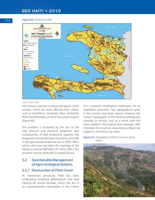
Figure 60: Soil Erosion Risk<br />
Source: CNIGS, 2009<br />
Soil erosion is present in almost all regions of the<br />
country. Some are more affected than others,<br />
such as Grand’Anse, Southeast, West, Artibonite,<br />
North and Northeast, at risk of very severe erosion<br />
(Figure 60).<br />
The problem is increased by the loss of the<br />
soils’ physical and chemical properties and,<br />
consequently, of their productive capacity. This<br />
progressive annual decrease has led to a shortfall<br />
in the agricultural productive sector (FAO, 2001),<br />
which until now had been the mainstay of the<br />
<strong>Haiti</strong>an economy (REPUBLIC OF HAITI, 2001). This<br />
situation may be attributed to several factors.<br />
5.2 Questionable Management<br />
of Agro-ecological Systems<br />
5.2.1 Destruction of Plant Cover<br />
As mentioned previously, <strong>Haiti</strong> has been<br />
undergoing sustained deforestation and land<br />
clearing for several decades, which has led to<br />
an unprecedented catastrophe in the history<br />
of a continent nevertheless well-known for its<br />
vegetation reduction. Few geographical areas<br />
in the country have been spared. However, the<br />
uneven topography of the territory predisposes<br />
naturally to erosion, and, as a result, with the<br />
heavy rainfall in this tropical zone (average 1,400<br />
mm/year), the country’s mountainous slopes are<br />
subject to soil erosion by water.<br />
Figure 61: Degradation of Plant Cover on Steep<br />
Slopes<br />
Source: Jean Vilmond Hilaire 2007


