

GEO Haiti 2010
GEO Haiti 2010
GEO Haiti 2010

Create successful ePaper yourself
Turn your PDF publications into a flip-book with our unique Google optimized e-Paper software.
State of the Environment Report <strong>2010</strong><br />
Millions of tons<br />
30 000<br />
25 000<br />
20 000<br />
15 000<br />
10 000<br />
5 000<br />
0<br />
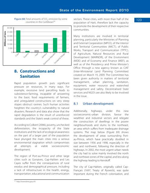
Figure 68: Total amounts of CO 2<br />
emission by some<br />
countries in the Caribbean 55<br />
Cuba<br />
Guyana<br />
<strong>Haiti</strong><br />
Jamaica<br />
Dominican Republic<br />
8. Constructions and<br />
Sanitation<br />
Trinidad & Tobago<br />
Rapid population growth puts significant<br />
pressure on resources, in many ways. For<br />
example, excessive land parcelling leads to<br />
subsistence-farming, incapable of answering<br />
to the basic food requirements of farmers,<br />
and unregulated constructions on very steep<br />
slopes obstruct ravines. Such human activities<br />
heighten the country’s vulnerability to natural<br />
disasters. Research and data also show that the<br />
rapid degradation is the result of unenforced<br />
standards and the State’s weak control of these.<br />
According to Colbert (2006), poverty, unchecked<br />
deforestation, the incapacity of the State<br />
institutions and the lack of ecological awareness<br />
on the part of a larger part of the population<br />
have plunged the main cities into a serious<br />
environmental stagnation which compromises<br />
all attempts at viable socioeconomic<br />
development.<br />
The region of Port-au-Prince and other large<br />
cities such as Gonaives, Cap-Haïtien and Les<br />
Cayes suffer from the consequences of rural<br />
exodus and demographical pressure, including<br />
a lack of infrastructure in the health, energy,<br />
transportation, educational and communication<br />
sectors. These cities, with more than half of the<br />
population of <strong>Haiti</strong>, therefore lack the capacity<br />
to promote the development of their respective<br />
communities.<br />
Many institutions are involved in territorial<br />
planning, particularly the Ministries of Planning<br />
and External Cooperation (MPCE), of the Interior<br />
and Territorial Communities (MICT), of Public<br />
Works, Transport and Communication (TPTC),<br />
of Agriculture, Natural Resources and Rural<br />
Development (MARNDR), of the Environment<br />
(MDE) and of Economy and Finance (MEF), as<br />
well as of the Presidency and Prime Minister’s<br />
Office through a new agency known as CIAT<br />
(Inter-Ministerial Land Planning Committee)<br />
created on March 19, 2009. The Committee has<br />
been given authority in matters of territorial<br />
management, urban planning, sanitation,<br />
equipment, water resource and watershed<br />
management and safety. Decentralised State<br />
services and NGO’s are also likely to be involved<br />
in the issue.<br />
8.1 Urban development<br />
Additionally, highways, under this new<br />
socioeconomic-urban division, favour the<br />
wealthier and industrial sectors and relegate<br />
the construction of dwellings in the poorer<br />
neighbourhoods and slums to the northeast,<br />
an area which suffers from inadequate drainage<br />
systems. The map below (Figure 69) shows<br />
the development of areas surrounding Portau-Prince,<br />
which have practically doubled in<br />
size between 1956 and 1998, especially in the<br />
east and northwest, following the direction of<br />
highways. In 2002, the most urgent urban needs<br />
the city had to solve mainly involved the north<br />
and northeast zones of the capital, and less along<br />
the highway leading to Kenskoff.<br />
The city of Cap-Haïtien, originally called Cap-<br />
Français (1697, Treaty of Ryswick), was quite<br />
important during the French colonisation, and<br />
123<br />
55<br />
http://www.bme.gouv.ht


