

GEO Haiti 2010
GEO Haiti 2010
GEO Haiti 2010

Create successful ePaper yourself
Turn your PDF publications into a flip-book with our unique Google optimized e-Paper software.
<strong>GEO</strong> HAITI • <strong>2010</strong><br />
50<br />
capital. These are the Western Department (main<br />
city, Port-au-Prince), the Southeastern Province<br />
(main city, Jacmel), the Southern Department (main<br />
city, Les Cayes), Nippes (main city, Miragoâne),<br />
Grand’Anse (main city, Jérémie), Artibonite<br />
Province (main city, Gonaïves), the Central Province<br />
(main city, Hinche) and the northern Provinces<br />
(North, Northeast and Northwest), with the main<br />
cities of Cap-Haïtien, Port de Paix and Fort Liberté,<br />
respectively. The country’s ten Departments 13 are<br />
divided into 42 districts, which are themselves<br />
divided into 140 towns that are further divided<br />
into 565 communities.<br />
1.3 Physiography<br />
1.3.1 Surface area and relief<br />
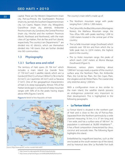
The territory of <strong>Haiti</strong> spans 28 704 km 2 which<br />
includes a main island (La Grande Terre:<br />
27 750 km 2 ) and 5 satellite islands which are La<br />
Gonâve (670 km 2 ), La Tortue (180 km 2 ), L’Île-à-Vache<br />
(52 km 2 ), Les Cayemites (45 km 2 ) and La Navassa<br />
(7 km 2 ). One of the geographical characteristics<br />
of <strong>Haiti</strong> is its steep topography. Almost 75% of the<br />
<strong>Haiti</strong>an landscape is comprised of steep mountain<br />
ranges with 50% of its the peaks having slopes<br />
above 40% (Figures 3 and 4).<br />
Figure 4: Relief of the Republic of <strong>Haiti</strong><br />
The country’s main relief is made up of:<br />
• The Northern mountain range with peaks<br />
ranging from 1,200 to 1,300 meters;<br />
• The Cahos Hills, the Black Mountains (Montagnes<br />
Noires), the Matheux Mountain range, the<br />
Trou d’Eau Hills with peaks reaching 1,200 to<br />
1,500 meters located in the central part of the<br />
country;<br />
• The La Selle mountain range (Southeast) which<br />
extends over 100 km and from which the La<br />
Selle peak rises to 2,674 meters, the highest<br />
point in the country;<br />
• The La Hotte mountain range, the peaks of<br />
which reach 2,347 meters at Morne Macaya<br />
(Southwest) (Figure 5).<br />
Moreover, various plains totalizing about<br />
7,000 km 2 occupy nearly a quarter of the country’s<br />
surface area: the Northern Plain, the Artibonite<br />
Plain, the Cul-de-Sac Plain, the Des Cayes Plain,<br />
the Léogâne and de l’Arbre Plains. The coastal strip<br />
only stretches along 1,500 km.<br />
With a configuration more or less similar to<br />
the main island, the satellite islands possess<br />
an endogenous potential very important to<br />
their development. This is highlighted in the<br />
following paragraphs.<br />
• La Tortue Island<br />
La Tortue Island is situated in the northern part<br />
of <strong>Haiti</strong> and is close to the city of Port-au-Paix.<br />
Separated from the Northern peninsula by a wide<br />
channel measuring 16 km, it is 37 km long and<br />
7 km wide, and has a surface area of 180 km 2 . Its<br />
population is estimated at 36,000 inhabitants 14 .<br />
It has a floral composition characterized by citrus,<br />
coconut and avocado trees. The following figure<br />
highlights this island.<br />
Source: (http://www.quid.fr/, section: monde-Haïti-relief )<br />
Embellished by magnificent beaches, such as the<br />
one located at the south-western tip of the island,<br />
and by historical sites (the La Rochelle Fort built<br />
13<br />
http://www.ht.undp.org/public/fichetechniquehaiti.php<br />
14<br />
http://www.campmandingue.com/ile%20de%20la%20tortue.htm


