GEO Haiti 2010
GEO Haiti 2010
GEO Haiti 2010
Create successful ePaper yourself
Turn your PDF publications into a flip-book with our unique Google optimized e-Paper software.
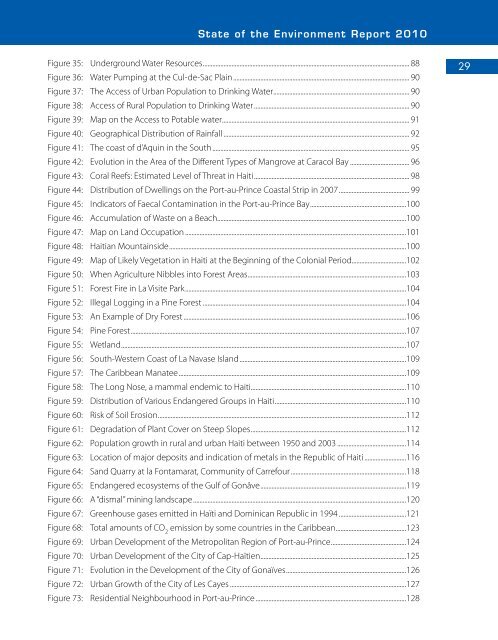
State of the Environment Report <strong>2010</strong><br />
Figure 35: Underground Water Resources................................................................................................................................. 88<br />
Figure 36: Water Pumping at the Cul-de-Sac Plain.............................................................................................................. 90<br />
Figure 37: The Access of Urban Population to Drinking Water..................................................................................... 90<br />
Figure 38: Access of Rural Population to Drinking Water................................................................................................. 90<br />
Figure 39: Map on the Access to Potable water..................................................................................................................... 91<br />
Figure 40: Geographical Distribution of Rainfall..................................................................................................................... 92<br />
Figure 41: The coast of d’Aquin in the South........................................................................................................................... 95<br />
Figure 42: Evolution in the Area of the Different Types of Mangrove at Caracol Bay...................................... 96<br />
Figure 43: Coral Reefs: Estimated Level of Threat in <strong>Haiti</strong>................................................................................................. 98<br />
Figure 44: Distribution of Dwellings on the Port-au-Prince Coastal Strip in 2007............................................ 99<br />
Figure 45: Indicators of Faecal Contamination in the Port-au-Prince Bay............................................................100<br />
Figure 46: Accumulation of Waste on a Beach......................................................................................................................100<br />
Figure 47: Map on Land Occupation...........................................................................................................................................101<br />
Figure 48: <strong>Haiti</strong>an Mountainside....................................................................................................................................................100<br />
Figure 49: Map of Likely Vegetation in <strong>Haiti</strong> at the Beginning of the Colonial Period..................................102<br />
Figure 50: When Agriculture Nibbles into Forest Areas...................................................................................................103<br />
Figure 51: Forest Fire in La Visite Park..........................................................................................................................................104<br />
Figure 52: Illegal Logging in a Pine Forest................................................................................................................................104<br />
Figure 53: An Example of Dry Forest............................................................................................................................................106<br />
Figure 54: Pine Forest............................................................................................................................................................................107<br />
Figure 55: Wetland..................................................................................................................................................................................107<br />
Figure 56: South-Western Coast of La Navase Island........................................................................................................109<br />
Figure 57: The Caribbean Manatee..............................................................................................................................................109<br />
Figure 58: The Long Nose, a mammal endemic to <strong>Haiti</strong>.................................................................................................110<br />
Figure 59: Distribution of Various Endangered Groups in <strong>Haiti</strong>..................................................................................110<br />
Figure 60: Risk of Soil Erosion...........................................................................................................................................................112<br />
Figure 61: Degradation of Plant Cover on Steep Slopes.................................................................................................112<br />
Figure 62: Population growth in rural and urban <strong>Haiti</strong> between 1950 and 2003............................................114<br />
Figure 63: Location of major deposits and indication of metals in the Republic of <strong>Haiti</strong> ..........................116<br />
Figure 64: Sand Quarry at la Fontamarat, Community of Carrefour........................................................................118<br />
Figure 65: Endangered ecosystems of the Gulf of Gonâve...........................................................................................119<br />
Figure 66: A “dismal” mining landscape.....................................................................................................................................120<br />
Figure 67: Greenhouse gases emitted in Haïti and Dominican Republic in 1994...........................................121<br />
Figure 68: Total amounts of CO 2<br />
emission by some countries in the Caribbean............................................123<br />
Figure 69: Urban Development of the Metropolitan Region of Port-au-Prince...............................................124<br />
Figure 70: Urban Development of the City of Cap-Haïtien...........................................................................................125<br />
Figure 71: Evolution in the Development of the City of Gonaïves...........................................................................126<br />
Figure 72: Urban Growth of the City of Les Cayes...............................................................................................................127<br />
Figure 73: Residential Neighbourhood in Port-au-Prince..............................................................................................128<br />
29


