Admiralty Lists of Radio Signals - The Tyneside Nautical Charts ...
Admiralty Lists of Radio Signals - The Tyneside Nautical Charts ...
Admiralty Lists of Radio Signals - The Tyneside Nautical Charts ...

You also want an ePaper? Increase the reach of your titles
YUMPU automatically turns print PDFs into web optimized ePapers that Google loves.
VI<br />
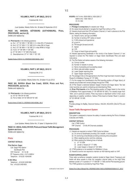
VOLUME 6, PART 2, NP 286(2), 2012/13<br />
Published Wk 19/12<br />
––––––––––––––––––<br />
(Last Updates: Weekly Edition No. 38 dated 20 September 2012)<br />
PAGE 345, SWEDEN, GÖTEBORG (GOTHENBURG), Pilots,<br />
PROCEDURE, section (6).<br />
Delete and replace by:<br />
(6) Pilot boards in the following positions:<br />
(a) No 1: 57°34′·50N 11°38′·80E (1·2 n miles SE <strong>of</strong> Trubaduren)<br />
(b) No 2: 57°37′·00N 11°31′·90E (2·5 n miles SW <strong>of</strong> Vinga)<br />
(c) No 3: 57°38′·80N 11°32′·50E (2 n miles WNW <strong>of</strong> Vinga)<br />
(d) VLCC: 57°38′·50N 11°29′·50E<br />
(e) 57°40′·20N 11°47′·60E (Rivö fjord)<br />
(f) Skandiahamnen: 57°41′·18N 11°52′·12E<br />
Swedish Notice 416/8141/12, (RSDRA2012000182424), 39/12<br />
––––––––––––––––––––––––––––––<br />
VOLUME 6, PART 3, NP 286(3), 2012/13<br />
Published Wk 27/12<br />
––––––––––––––––––<br />
(Last Updates: Weekly Edition No. 29 dated 19 July 2012)<br />
PAGE 303, RUSSIA (Black Sea Coast), SOCHI, Pilots and Port,<br />
PROCEDURE, section (8).<br />
Delete and replace by:<br />
(8) Pilot boards in the following positions:<br />
(a) 43°32′·70N 39°43′·00E<br />
(b) Port <strong>of</strong> Adler: 43°23′·95N 39°54′·42E<br />
Russian Notice 37/5467/12, (RSDRA2012000183586), 39/12<br />
––––––––––––––––––––––––––––––<br />
VOLUME 6, PART 4, NP 286(4), 2012/13<br />
Published Wk 31/12<br />
––––––––––––––––––<br />
(Last Updates: Weekly Edition No. 37 dated 13 September 2012)<br />
PAGE 141, INDIA, HUGLI RIVER, Pilots and Vessel Traffic Management<br />
System sections.<br />
Delete and replace by:<br />
Pilots<br />
CONTACT DETAILS:<br />
Pilot Station, Sagar<br />
Call: Sagar Pilot Station<br />
Sandheads Pilot<br />
VHF Channel: Ch 16; 68<br />
RT Frequency (kHz): 4147·4 8295·4<br />
Telephone: +91(0)32 10240348<br />
Hr Mr Office<br />
Telephone: +91(0)33 24391884<br />
Fax: +91(0)33 24391853<br />
continued on next column<br />
HOURS: 4147·4 kHz: 0500-0900 & 1600-2200 LT<br />
8295·5 kHz: 1000-1630 LT<br />
Ch 16: H24<br />
PROCEDURE:<br />
(1) Pilotage is compulsory for vessels over 100 gt.<br />
(2) No vessel should attempt to navigate the Hugli River without a Pilot.<br />
(3) Vessels should send their ETA at Eastern Channel Lt V well in advance to the Pilot<br />
Station, stating the following information:<br />
(a) Vessel’s name, call sign and MMSI<br />
(b) Number <strong>of</strong> working VHF radios on board<br />
(c) If AIS onboard and operational<br />
(d) gt and nt<br />
(e) FW draught (forward and aft)<br />
(f) Speed<br />
(g) LOA<br />
(h) Cargo on board (type and quantity)<br />
(4) Vessels approaching Sandheads in the vicinity <strong>of</strong> the Eastern Channel Lt V are<br />
required to contact the Pilot Station on Sagar Island (Sandheads Pilot) and await<br />
instructions.<br />
(5) <strong>The</strong> Pilot Station will advise vessels <strong>of</strong> the following information:<br />
(a) Convoy number<br />
(b) Number <strong>of</strong> vessels in convoy<br />
(c) Name <strong>of</strong> preceding and succeeding vessel<br />
(d) Which side pilot ladder required<br />
(e) Lower Gasper reporting time<br />
(f) Upper Gasper reporting time<br />
(6) <strong>The</strong> pilotage limits on the approaches to the River Hugli have been moved to Sagar<br />
Roads N <strong>of</strong> Middleton Fairway (21°37′·00N).<br />
(7) For the voyage from Sandheads to the Pilot boarding position <strong>of</strong>f Sagar Island, all<br />
vessels are provided with remote pilotage through the VTMS.<br />
(8) A Pilot Vessel is stationed between Gasper Channel and Sagar Island. Two fast<br />
motor launches are used for embarking and disembarking Pilots.<br />
(9) River Pilot boards at the Pilot boarding position <strong>of</strong>f Sagar Island (in the vicinity<br />
<strong>of</strong> Middleton Point (approximately 21°35′·00N 88°05′·00E)). For vessels longer than<br />
160m, and in particular tankers, Pilots may board or disembark further S than usual<br />
depending on weather conditions. Harbour Pilots board at Garden Reach in position<br />
22°33′·00N 88°19′·00E.<br />
NOTE:<br />
Provides pilotage for BajBaj, Diamond Harbour, HALDIA, KOLKATA (CALCUTTA) and<br />
Sagar.<br />
Vessel Traffic Management System<br />
DESCRIPTION:<br />
This system is designed to improve the safety <strong>of</strong> vessels entering the Ports <strong>of</strong> Kolkata<br />
(Calcutta) and Haldia.<br />
CONTACT DETAILS:<br />
Call: VTMS Control<br />
VHF Channel: Ch 68 (All Channels available)<br />
PROCEDURE:<br />
(1) Vessels are required to contact VTMS Control as follows:<br />
(a) On arrival at Sandheads providing LOA, breadth, nt and draught<br />
(b) On anchoring at Sandheads providing anchoring time and position<br />
(c) When weighing anchor and time underway<br />
(d) When passing the following lines <strong>of</strong> latitude:<br />
(i) 21°10′·00N<br />
(ii) Jonaki Lt Vessel (21°17′·00N)<br />
(iii) Lower Gasper Lt Vessel (21°22′·00N)<br />
(2) VTMS guidance is not available N <strong>of</strong> Middleton Lt buoy.<br />
(3) Vessels at anchor are required to maintain an H24 listening watch on VHF.<br />
RADAR SURVEILLANCE:<br />
Three radar surveillance navigation systems located at Sagar Island, Frasergunj and<br />
Haldia will allow vessels to enter the navigation channel safely on the Hugli Delta<br />
between Jonaki Lt F in position 21°17′·00N 88°11′·50E and the Pilot boarding ground.<br />
<strong>The</strong> VTMS guidance is provided by Hugli River Pilots.<br />
Kolkata Port & Bay <strong>of</strong> Bengal Pilot, (RSDRA2012000174033 & RSDRA2007000041517), 39/12<br />
Wk39/12<br />
6.4