Viru-Peipsi veemajanduskava - Keskkonnaministeerium
Viru-Peipsi veemajanduskava - Keskkonnaministeerium
Viru-Peipsi veemajanduskava - Keskkonnaministeerium

You also want an ePaper? Increase the reach of your titles
YUMPU automatically turns print PDFs into web optimized ePapers that Google loves.
3.3.2 Rannikuvee kvaliteediklassid<br />
63<br />
3.3.2 Ecological status classes of coastal waters<br />
Vainupea nina juures (vt joonis 3.1). Silmas pidades<br />
alamvesikondade piiri (mis asub Eru lahes)<br />
oleks vajalik läbi viia täiendav analüüs eesmärgiga<br />
näidata, kas rannikuvee tüüpide I ja III piiri ühildamine<br />
alamvesikonna piiriga (mis oleks <strong>veemajanduskava</strong>de<br />
mõttes otstarbekam) oleks kõikide<br />
analüüsitud parameetrite (ka ökosüsteemi parameetrite)<br />
jaoks õigustatud.<br />
Veepoliitika Raamdirektiivi V lisa tabelis 1.2.4 on<br />
ära määratletud rannikuvee väga hea, hea ja rahuldav<br />
ökoloogiline seisund bioloogiliste, hüdromorfoloogiliste<br />
ja füüsikalis-keemiliste kvaliteedielementide<br />
jaoks. Selle põhjal on ökoloogilise<br />
klassifikatsiooni süsteemi algelemendiks “häirimatu“<br />
olek ehk võrdlustingimused, mis peavad olema<br />
tüübi-spetsiifilised, st defineeritud iga tüübi<br />
jaoks eraldi. Võrdlustingimused peavad arvesse<br />
võtma nii ruumilist kui ajalist muutlikkust, mis esimore<br />
specifically, the locations of areas of sharper<br />
changes, and taking into account also the<br />
behaviour of the ecosystem parameters in the<br />
studied sea area (as the types of coastal waters<br />
have to be clearly distinguishable also on the basis<br />
of ecosystem parameters), a provisional proposal<br />
was made to draw the line between type I and<br />
type III along the meridian of 26º16' E, which cuts<br />
the coast approximately at Vainupea Cape (see Figure<br />
3.1). Considering the location of the boundary<br />
of river basin sub-districts (in Eru Bay), it would be<br />
necessary to carry out an additional analysis to<br />
clarify whether the combining of the boundary of<br />
type I and type III of coastal waters with that of<br />
river basin sub-districts (which would be practical<br />
for the purpose of water management plans)<br />
would be justified in terms of all the factors<br />
analysed, including ecosystem parameters.<br />
3.3.2 Rannikuvee kvaliteediklassid<br />
3.3.2 Ecological status classes of coastal<br />
waters<br />
Table 1.2.4 of Annex V of the Water Framework<br />
Directive defines the high, good and moderate<br />
ecological status of coastal waters on the basis of<br />
biological, hydromorphological and physicochemical<br />
quality elements. According to this division,<br />
the basic element of the ecological classification<br />
is the “undisturbed status” or reference<br />
conditions, which have to be type-specific, i.e.<br />
established separately for each individual type.<br />
Reference conditions have to take into account<br />
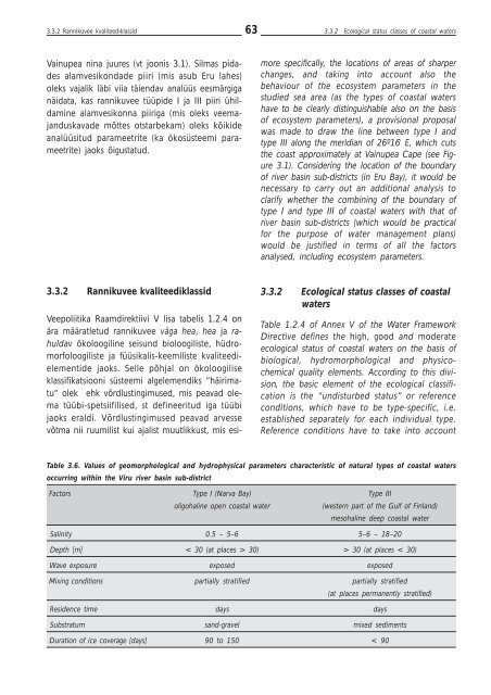
Table 3.6. Values of geomorphological and hydrophysical parameters characteristic of natural types of coastal waters<br />
occurring within the <strong>Viru</strong> river basin sub-district<br />
Factors Type I (Narva Bay) Type III<br />
oligohaline open coastal water<br />
(western part of the Gulf of Finland)<br />
mesohaline deep coastal water<br />
Salinity 0.5 – 5–6 5–6 – 18–20<br />
Depth [m] < 30 (at places > 30) > 30 (at places < 30)<br />
Wave exposure exposed exposed<br />
Mixing conditions partially stratified partially stratified<br />
(at places permanently stratified)<br />
Residence time days days<br />
Substratum sand-gravel mixed sediments<br />
Duration of ice coverage [days] 90 to 150 < 90