
Create successful ePaper yourself
Turn your PDF publications into a flip-book with our unique Google optimized e-Paper software.
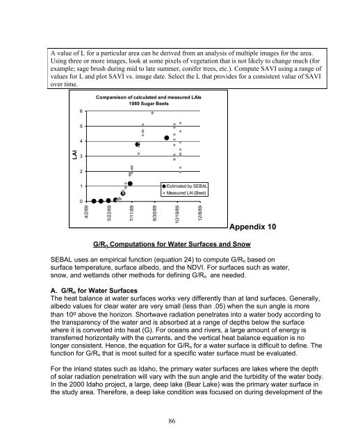
A value of L for a particular area can be derived from an analysis of multiple images for the area.Using three or more images, look at some pixels of vegetation that is not likely to change much (forexample; sage <strong>br</strong>ush during mid to late summer, conifer trees, etc.). Compute SAVI using a range ofvalues for L and plot SAVI vs. image date. Select the L that provides for a consistent value of SAVIover time.6Compareison of calculated and measured LAIs1989 Sugar Beets54LAI3210Estimated by <strong>SEBAL</strong>Measured LAI (Beet)4/2/895/22/897/11/898/30/8910/19/8912/8/89Appendix 10G/R n Computations for Water Surfaces and Snow<strong>SEBAL</strong> uses an empirical function (equation 24) to compute G/R n based onsurface temperature, surface albedo, and the NDVI. For surfaces such as water,snow, and wetlands other methods for defining G/R n are needed.A. G/R n for Water SurfacesThe heat balance at water surfaces works very differently than at land surfaces. Generally,albedo values for clear water are very small (less than .05) when the sun angle is morethan 10 o above the horizon. Shortwave radiation penetrates into a water body according tothe transparency of the water and is absorbed at a range of depths below the surfacewhere it is converted into heat (G). For oceans and rivers, a large amount of energy istransferred horizontally with the currents, and the vertical heat balance equation is nolonger consistent. Hence, the equation for G/R n for a water surface is difficult to define. Thefunction for G/R n that is most suited for a specific water surface must be evaluated.For the inland states such as Idaho, the primary water surfaces are lakes where the depthof solar radiation penetration will vary with the sun angle and the turbidity of the water body.In the 2000 Idaho project, a large, deep lake (Bear Lake) was the primary water surface inthe study area. Therefore, a deep lake condition was focused on during development of the86