- Page 1 and 2:
High Resolution 1:10,000 scale Mapp
- Page 3 and 4:
6 7 8 9 5.4 Mapping Requirement for
- Page 5 and 6:
TECHNOLOGY FOR 1:10,000 SCALE MAPPI
- Page 7 and 8:
10 11 Table 9.1 Table 9.2 Table 9.3
- Page 9 and 10:
Appendix No. Heading no. APPENDICES
- Page 11 and 12:
XIV APP 13.1 Methodology For Aerial
- Page 13 and 14:
APP 19.9 Pure Server - Map Servers
- Page 15 and 16:
Figure APP 5.2 Figure APP 5.3 Table
- Page 17 and 18:
Figure APP 20.4 Design of GCP Libra
- Page 19 and 20:
CWC Central Water Commission LIDRA
- Page 21 and 22:
BMTPC Building Materials and Techno
- Page 23 and 24:
Formerly known as PUCC, the Digital
- Page 25 and 26:
The Toronto Mono Viewer (TMV) is an
- Page 27 and 28:
Preamble Map is an attempt to depic
- Page 29 and 30:
Survey of India is already in posse
- Page 31 and 32:
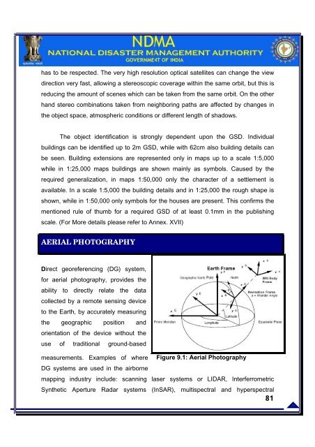
uildings can be comfortably depicte
- Page 33 and 34:
The seismo-tectonics of India is un
- Page 35 and 36:
Figure 2. 2: Landslide Hazard Map (
- Page 37 and 38:
The combined threat from these majo
- Page 39 and 40:
prepared at various accuracies. For
- Page 41 and 42:
CHAPTER 3 GEOGRAPHICAL INFORMATION
- Page 43 and 44:
SN PHASE DESCRIPTION 1 PLANNING 2 M
- Page 45 and 46:
egional, city, state and national l
- Page 47 and 48:
GIS DATABASE FOR DISASTER MANAGEMEN
- Page 49 and 50:
quantitative in nature and GIS is u
- Page 51 and 52:
4. Source Procurement: passive and
- Page 53 and 54:
India meteorological department is
- Page 55 and 56: QUALITY CHECK FOR IMPACT FOR HAZARD
- Page 57 and 58: SUMMRY FOR CYCLONE HAZARD ZONATION
- Page 59 and 60: Mostly the coastal districts of Wes
- Page 61 and 62: 1. Aerial mapping at scale 1:2,000
- Page 63 and 64: e. Selection of the predictive rela
- Page 65 and 66: Studies and other information PHASE
- Page 67 and 68: Solution: It is assumed that the at
- Page 69 and 70: For example earthquake 1 gives an i
- Page 71 and 72: CHAPTER 6 METHODOLOGY FOR FLOOD HAZ
- Page 73 and 74: Figure 6.2 : Major rivers in India
- Page 75 and 76: Andhra Pradesh coastal rivers Penne
- Page 77 and 78: Indus river basin Rivers flowing in
- Page 79 and 80: Year 1953 1954 1955 1956 1957 1958
- Page 81 and 82: Figure 6.4 : Year wise total damage
- Page 83 and 84: extent of flooding for an expected
- Page 85 and 86: METHODOLOGY OF FLOOD HAZARD ZONING
- Page 87 and 88: Catchment Area Rainfall measurement
- Page 89 and 90: BASE MAP INFORMATION Land surface r
- Page 91 and 92: and hilly areas, which corresponds
- Page 93 and 94: 7. The DEM/DSM/DTM model to be crea
- Page 95 and 96: CHAPTER 7 METHODOLOGY FOR HAZARD MA
- Page 97 and 98: should show the locations of previo
- Page 99 and 100: LANDSLIDE HAZARD ZONATION MODELING
- Page 101 and 102: MAPPING REQUIREMENT FOR LANDSLIDE H
- Page 103 and 104: was that ground control points (GCP
- Page 105: The following methodologies may be
- Page 109 and 110: Generation 0.5 m 1 m 2.5 m 5m and A
- Page 111 and 112: A brief comparative of the various
- Page 113 and 114: 1:10,000 0.25 m 2.5 m 1:16,000 0.25
- Page 115 and 116: Some of the available sensors resol
- Page 117 and 118: Distance between successive ground
- Page 119 and 120: � Ortho-rectified geo-coded produ
- Page 121 and 122: CARTOSAT 1 There is now an increasi
- Page 123 and 124: Standard Products 01 02 03 Radiomet
- Page 125 and 126: performance star sensors, imaging a
- Page 127 and 128: Digital data format- Geo TIFF Preci
- Page 129 and 130: Spectral Range 450-900 nm Swath Wid
- Page 131 and 132: miles) per day of half-meter imager
- Page 133 and 134: CHAPTER 11 REQUIRED ACCURACIES Earl
- Page 135 and 136: changed on UTM). 5. Theme Content C
- Page 137 and 138: cent of the country is covered. The
- Page 139 and 140: accuracies in X, Y and Z director,
- Page 141 and 142: 2) 2D feature extraction Extraction
- Page 143 and 144: perceptions, accuracy of Contour ge
- Page 145 and 146: 8. AQC system based on NSD / OGC /
- Page 147 and 148: Resampling NN Not Applicable KD16 F
- Page 149 and 150: Product Type � All Geocoded produ
- Page 151 and 152: Full Vectorization Except Contours
- Page 153 and 154: IKONOS HIGH RESOLUTION SATELLITE IM
- Page 155 and 156: � There is a 210 sq. km minimum o
- Page 157 and 158:
Optical Data Processing Options Opt
- Page 159 and 160:
Core Processor Inertially Aided RTK
- Page 161 and 162:
The Task Force constituted Thematic
- Page 163 and 164:
APPENDICES App 1
- Page 165 and 166:
Zone and district management - Main
- Page 167 and 168:
Sensitive zones impact/damage DESIG
- Page 169 and 170:
5 Performance resolution obtained.
- Page 171 and 172:
Phase I: Development Diagnosis, Str
- Page 173 and 174:
Studies and other information Anima
- Page 175 and 176:
All tropical cyclones are areas of
- Page 177 and 178:
Deep Depression Cyclonic Storm Seve
- Page 179 and 180:
depression and moves overland in se
- Page 181 and 182:
the deaths of about 1 million perso
- Page 183 and 184:
APPENDIX IV METHODOLOGY FOR HAZARD
- Page 185 and 186:
The intra plate earthquakes such as
- Page 187 and 188:
into Euranasian Plate at a rate of
- Page 189 and 190:
of the normal perimeter of the body
- Page 191 and 192:
Infact, magnitude is the measuremen
- Page 193 and 194:
Degree Force Behavioral effects Str
- Page 195 and 196:
EARTHQUAKE HAZARD ESTIMATE ISOSIESM
- Page 197 and 198:
influencing factors are the propert
- Page 199 and 200:
Mass wasting is a generic term refe
- Page 201 and 202:
Water Table Potential Failure Plane
- Page 203 and 204:
C + ( γ -mγw)zcosβ cosβ tanΦ S
- Page 205 and 206:
τ shear stress σ normal stress μ
- Page 207 and 208:
APPENDIX VI SATELITE IMAGING TECHNI
- Page 209 and 210:
2 3 4 5 Laser and radar altimeters
- Page 211 and 212:
more detail, less coverage. The ski
- Page 213 and 214:
2 3 4 Spectral resolution Radiometr
- Page 215 and 216:
Analysis is the recently developed
- Page 217 and 218:
3 4 Variables mapped on uniform spa
- Page 219 and 220:
Figure App 6.1: Elements of image R
- Page 221 and 222:
Viewing Direction The first imaging
- Page 223 and 224:
CCD- configuration Most of the sens
- Page 225 and 226:
Multi spectral information Sensors
- Page 227 and 228:
handed system. ITRF is a set of poi
- Page 229 and 230:
way monuments or control points. Th
- Page 231 and 232:
2 3 4 5 6 New software is now intro
- Page 233 and 234:
Research has expanded to include an
- Page 235 and 236:
DWG, SVC, and ASV. In order to comp
- Page 237 and 238:
SPOT-4 Franc e 3/24/1998 10 20 120
- Page 239 and 240:
Hi-res Sterio Imaging China 7/1/200
- Page 241 and 242:
To The Chief Secretaries of all Sta
- Page 243 and 244:
(b) Security Clearance for Aerial P
- Page 245 and 246:
vicinity of Vas/VPs, the requiremen
- Page 247 and 248:
the flight track flown by the aircr
- Page 249 and 250:
(c) Unrestricted: All AP/ABRSD&I ot
- Page 251 and 252:
the three Services Intelligence Age
- Page 253 and 254:
(v) All transfers of photographs/im
- Page 255 and 256:
(x) without internet connectivity.
- Page 257 and 258:
Copy forwarded to:- All Ministries/
- Page 259 and 260:
(g) Type of Camera/sensor being use
- Page 261 and 262:
(xii) Travelling allowance/daily al
- Page 263 and 264:
photography/remote sensing. (ii) No
- Page 265 and 266:
Land; VGL- Very Good Land; MGL - Mo
- Page 267 and 268:
GCPS (GPS) Field verification and d
- Page 269 and 270:
Business Hotel Hostel Guest house C
- Page 271 and 272:
Religious Antiquities Utility Cente
- Page 273 and 274:
Other Institutions Welfare/reli ef/
- Page 275 and 276:
Centre Line of River < 3 m River be
- Page 277 and 278:
Canal Features Communication Works
- Page 279 and 280:
Pier Light house Lightship Buoy Tid
- Page 281 and 282:
Level Crossing Speed Bump/ Speed Hu
- Page 283 and 284:
Air traffic control (ATC) Tower Lan
- Page 285 and 286:
Inland Wetlands Water-Logged Marshy
- Page 287 and 288:
Power Line infrastructure Pylon Pyl
- Page 289 and 290:
Oil Pipe Line Infrastructure Oil St
- Page 291 and 292:
Solid waste collection points Compo
- Page 293 and 294:
Tahsil/Taluk/Mandal/Pragana Block V
- Page 295 and 296:
ecognized internationally or approv
- Page 297 and 298:
FIDUCIAL MARKS IN NEGATIVES AND CAL
- Page 299 and 300:
o In the upper left-hand corner: Da
- Page 301 and 302:
may be cause for rejection. However
- Page 303 and 304:
APPENDIX XIV NRSA EMPANELMENT PROCE
- Page 305 and 306:
hrs. & 1600 hrs. You may also down
- Page 307 and 308:
2.5.1 GPS control points list with
- Page 309 and 310:
5 b 5 c 5 d 5 e 5 f 5 g Working in
- Page 311 and 312:
11 Other relevant information (plea
- Page 313 and 314:
Exterior Orientation (EO) file -( e
- Page 315 and 316:
04 Technical employees who are on t
- Page 317 and 318:
Scale Contour Interval Any other ma
- Page 319 and 320:
APPENDIX XV AERIAL MAPPING- LIST OF
- Page 321 and 322:
Optech a privately owned company, O
- Page 323 and 324:
Applanix Mobile Mapping and Positio
- Page 325 and 326:
Fairchild Imaging develops and manu
- Page 327 and 328:
TOPCON From survey to inspection, T
- Page 329 and 330:
NOVATEL INC NovAtel Inc. is a leadi
- Page 331 and 332:
APPENDIX XVII SATELLITE IMAGERY- LI
- Page 333 and 334:
GEOEYE GeoEye, Inc. is a premier pr
- Page 335 and 336:
10. Speak Systems Ltd B-49, Ec, Kus
- Page 337 and 338:
Export & Rsearch (P) Ltd 46. Lumino
- Page 339 and 340:
77. Trimble Navigation India Pvt. L
- Page 341 and 342:
and a fast growing set of geoscient
- Page 343 and 344:
OTHER GIS TOOLS- UNCLASSIFIED 1. Ch
- Page 345 and 346:
3. Informix - Allows spatial queryi
- Page 347 and 348:
ERDAS ERDAS IMAGINE Yes No Yes No N
- Page 349 and 350:
Suite My World GIS home Trial No Ye
- Page 351 and 352:
(COM & Java & .NET) Solaris & AIX &
- Page 353 and 354:
PURE SERVER - MAP SERVERS Name Lang
- Page 355 and 356:
MIXED Name Language WMS WFS WFS-T W
- Page 357 and 358:
PURE WEB CLIENT LIBRARIES Name Lang
- Page 359 and 360:
t MOBILE CLIENTS LICENSE & PLATFORM
- Page 361 and 362:
gvSIG Mini Yes Yes No Yes No No No
- Page 363 and 364:
- Product Size (Worldview) will be
- Page 365 and 366:
constantly change in time. It is th
- Page 367 and 368:
Continuously Operating Reference St
- Page 369 and 370:
geodetic datum. GPS observations ar
- Page 371 and 372:
and not in well defined network mod
- Page 373 and 374:
3. Block Adjustment As it has been
- Page 375 and 376:
Figure App 20.7: Imaging procedure
- Page 377 and 378:
• the perspective center of the c
- Page 379 and 380:
Figure App 20.9: DTM Modeling Digit
- Page 381 and 382:
lessens the effect of topographic r
- Page 383 and 384:
An image or photograph with an orth
- Page 385 and 386:
Figure App 20.10 a,b : Orthoimagery
- Page 387 and 388:
APPENDIX- XXI POSSIBLE PPP MODEL WI
- Page 389 and 390:
private players who can generate th
- Page 391 and 392:
employees in 1999. The ban on fresh
- Page 393 and 394:
(f) envisage that the respective ow
- Page 395 and 396:
Core Activities SOI Repetetive Acti
- Page 397 and 398:
ights of each zone on the basis of
- Page 399 and 400:
11. Remote monitoring and online da
- Page 401 and 402:
• Available with a number of opti
- Page 403 and 404:
• 2 GPS Receivers, Dual Frequency
- Page 405 and 406:
earthquake/disaster areas, landslid
- Page 407 and 408:
6) SYSTEM COMPONENTS Airborne Surve
- Page 409 and 410:
Parameter Gimbal encoder input, AUX
- Page 411:
• Airborne Survey PCS Firmware Op