

Inventory and Survey Methods for Nonindigenous Plant Species (PDF)
Inventory and Survey Methods for Nonindigenous Plant Species (PDF)
Inventory and Survey Methods for Nonindigenous Plant Species (PDF)
- No tags were found...

Create successful ePaper yourself
Turn your PDF publications into a flip-book with our unique Google optimized e-Paper software.
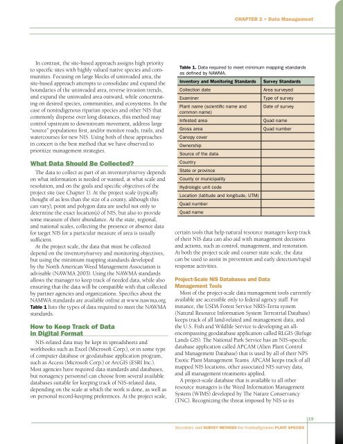
Chapter 2 • Data ManagementIn contrast, the site-based approach assigns high priorityto specific sites with highly valued native species <strong>and</strong> communities.Focusing on large blocks of uninvaded area, thesite-based approach attempts to consolidate <strong>and</strong> exp<strong>and</strong> theboundaries of the uninvaded area, reverse invasion trends,<strong>and</strong> exp<strong>and</strong> the uninvaded area outward, while concentratingon desired species, communities, <strong>and</strong> ecosystems. In thecase of nonindigenous riparian species <strong>and</strong> other NIS thatcommonly disperse over long distances, this method maycontrol upstream to downstream movement, address large“source” populations first, <strong>and</strong>/or monitor roads, trails, <strong>and</strong>watercourses <strong>for</strong> new NIS. Using both of these approachesin concert is the best method that we have observed toprioritize management strategies.What Data Should Be Collected?The data to collect as part of an inventory/survey dependson what in<strong>for</strong>mation is needed or wanted, at what scale <strong>and</strong>resolution, <strong>and</strong> on the goals <strong>and</strong> specific objectives of theproject site (see Chapter 1). At the project scale (typicallythought of as less than the size of a county, although thiscan vary), point <strong>and</strong> polygon data are useful not only todetermine the exact location(s) of NIS, but also to providesome measure of their abundance. At the state, regional,<strong>and</strong> national scales, collecting the presence or absence data<strong>for</strong> target NIS <strong>for</strong> a particular measure of area is usuallysufficient.At the project scale, the data that must be collecteddepend on the inventory/survey <strong>and</strong> monitoring objectives,but using the minimum mapping st<strong>and</strong>ards developedby the North American Weed Management Association isadvisable (NAWMA 2003). Using the NAWMA st<strong>and</strong>ardsallows the manager to keep track of needed data, while alsoensuring that the data will be compatible with that collectedby partner agencies <strong>and</strong> organizations. Specifics about theNAMWA st<strong>and</strong>ards are available online at www.nawma.org.Table 1 lists the types of data required to meet the NAWMAst<strong>and</strong>ards.How to Keep Track of Datain Digital FormatNIS-related data may be kept in spreadsheets <strong>and</strong>workbooks such as Excel (Microsoft Corp.), or in some typeof computer database or geodatabase application program,such as Access (Microsoft Corp.) or ArcGIS (ESRI Inc.).Most agencies have required data st<strong>and</strong>ards <strong>and</strong> databases,but nonagency personnel can choose from several availabledatabases suitable <strong>for</strong> keeping track of NIS-related data,depending on the scale at which the work is done, as well ason personal record-keeping preferences. At the project scale,Table 1. Data required to meet minimum mapping st<strong>and</strong>ardsas defined by NAWMA.<strong>Inventory</strong> <strong>and</strong> Monitoring St<strong>and</strong>ardsCollection dateExaminer<strong>Plant</strong> name (scientific name <strong>and</strong>common name)Infested areaGross areaCanopy coverOwnershipSource of the dataCountryState or provinceCounty or municipalityHydrologic unit codeLocation (latitude <strong>and</strong> longitude, UTM)Quad numberQuad name<strong>Survey</strong> St<strong>and</strong>ardsArea surveyedType of surveyDate of surveyQuad nameQuad numbercertain tools that help natural resource managers keep trackof their NIS data can also aid with management decisions<strong>and</strong> actions, such as control, management, <strong>and</strong> restoration.At both the project scale <strong>and</strong> coarser state scale, the datacan be used to assist in prevention <strong>and</strong> early detection/rapidresponse activities.Project-Scale NIS Databases <strong>and</strong> DataManagement ToolsMost of the project-scale data management tools currentlyavailable are accessible only to federal agency staff. Forinstance, the USDA Forest Service NRIS-Terra system(Natural Resource In<strong>for</strong>mation System Terrestrial Database)keeps track of all l<strong>and</strong>-related <strong>and</strong> management data, <strong>and</strong>the U.S. Fish <strong>and</strong> Wildlife Service is developing an allencompassinggeodatabase application called RLGIS (RefugeL<strong>and</strong>s GIS). The National Park Service has an NIS-specificdatabase application called APCAM (Alien <strong>Plant</strong> Control<strong>and</strong> Management Database) that is used by all of their NPSExotic <strong>Plant</strong> Management Teams. APCAM keeps track of allmapped NIS locations, other associated NIS survey data,<strong>and</strong> all management treatments applied.A project-scale database that is available to all otherresource managers is the Weed In<strong>for</strong>mation ManagementSystem (WIMS) developed by The Nature Conservancy(TNC). Recognizing the threat imposed by NIS to its19<strong>Inventory</strong> <strong>and</strong> <strong>Survey</strong> <strong>Methods</strong> <strong>for</strong> <strong>Nonindigenous</strong> <strong>Plant</strong> <strong>Species</strong>


