

Inventory and Survey Methods for Nonindigenous Plant Species (PDF)
Inventory and Survey Methods for Nonindigenous Plant Species (PDF)
Inventory and Survey Methods for Nonindigenous Plant Species (PDF)
- No tags were found...

You also want an ePaper? Increase the reach of your titles
YUMPU automatically turns print PDFs into web optimized ePapers that Google loves.
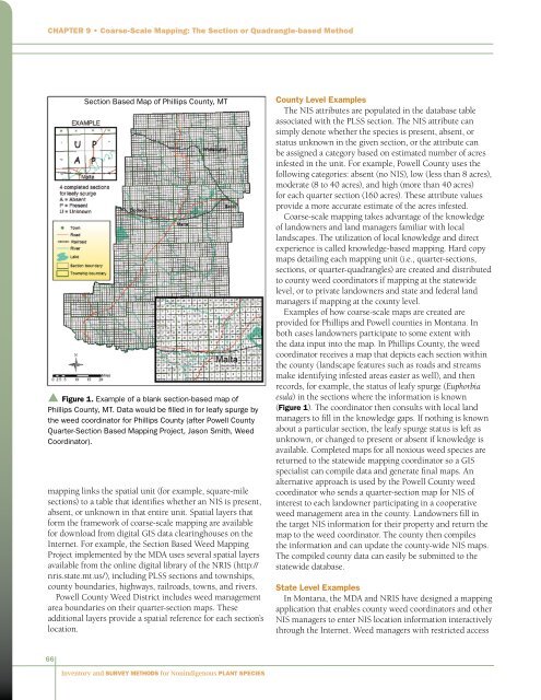
Chapter 9 • Coarse-Scale Mapping: The Section or Quadrangle-based MethodSection Based Map of Phillips County, MT▲ Figure 1. Example of a blank section-based map ofPhillips County, MT. Data would be filled in <strong>for</strong> leafy spurge bythe weed coordinator <strong>for</strong> Phillips County (after Powell CountyQuarter-Section Based Mapping Project, Jason Smith, WeedCoordinator).mapping links the spatial unit (<strong>for</strong> example, square-milesections) to a table that identifies whether an NIS is present,absent, or unknown in that entire unit. Spatial layers that<strong>for</strong>m the framework of coarse-scale mapping are available<strong>for</strong> download from digital GIS data clearinghouses on theInternet. For example, the Section Based Weed MappingProject implemented by the MDA uses several spatial layersavailable from the online digital library of the NRIS (http://nris.state.mt.us/), including PLSS sections <strong>and</strong> townships,county boundaries, highways, railroads, towns, <strong>and</strong> rivers.Powell County Weed District includes weed managementarea boundaries on their quarter-section maps. Theseadditional layers provide a spatial reference <strong>for</strong> each section’slocation.County Level ExamplesThe NIS attributes are populated in the database tableassociated with the PLSS section. The NIS attribute cansimply denote whether the species is present, absent, orstatus unknown in the given section, or the attribute canbe assigned a category based on estimated number of acresinfested in the unit. For example, Powell County uses thefollowing categories: absent (no NIS), low (less than 8 acres),moderate (8 to 40 acres), <strong>and</strong> high (more than 40 acres)<strong>for</strong> each quarter section (160 acres). These attribute valuesprovide a more accurate estimate of the acres infested.Coarse-scale mapping takes advantage of the knowledgeof l<strong>and</strong>owners <strong>and</strong> l<strong>and</strong> managers familiar with locall<strong>and</strong>scapes. The utilization of local knowledge <strong>and</strong> directexperience is called knowledge-based mapping. Hard copymaps detailing each mapping unit (i.e., quarter-sections,sections, or quarter-quadrangles) are created <strong>and</strong> distributedto county weed coordinators if mapping at the statewidelevel, or to private l<strong>and</strong>owners <strong>and</strong> state <strong>and</strong> federal l<strong>and</strong>managers if mapping at the county level.Examples of how coarse-scale maps are created areprovided <strong>for</strong> Phillips <strong>and</strong> Powell counties in Montana. Inboth cases l<strong>and</strong>owners participate to some extent withthe data input into the map. In Phillips County, the weedcoordinator receives a map that depicts each section withinthe county (l<strong>and</strong>scape features such as roads <strong>and</strong> streamsmake identifying infested areas easier as well), <strong>and</strong> thenrecords, <strong>for</strong> example, the status of leafy spurge (Euphorbiaesula) in the sections where the in<strong>for</strong>mation is known(Figure 1). The coordinator then consults with local l<strong>and</strong>managers to fill in the knowledge gaps. If nothing is knownabout a particular section, the leafy spurge status is left asunknown, or changed to present or absent if knowledge isavailable. Completed maps <strong>for</strong> all noxious weed species arereturned to the statewide mapping coordinator so a GISspecialist can compile data <strong>and</strong> generate final maps. Analternative approach is used by the Powell County weedcoordinator who sends a quarter-section map <strong>for</strong> NIS ofinterest to each l<strong>and</strong>owner participating in a cooperativeweed management area in the county. L<strong>and</strong>owners fill inthe target NIS in<strong>for</strong>mation <strong>for</strong> their property <strong>and</strong> return themap to the weed coordinator. The county then compilesthe in<strong>for</strong>mation <strong>and</strong> can update the county-wide NIS maps.The compiled county data can easily be submitted to thestatewide database.State Level ExamplesIn Montana, the MDA <strong>and</strong> NRIS have designed a mappingapplication that enables county weed coordinators <strong>and</strong> otherNIS managers to enter NIS location in<strong>for</strong>mation interactivelythrough the Internet. Weed managers with restricted access66<strong>Inventory</strong> <strong>and</strong> <strong>Survey</strong> <strong>Methods</strong> <strong>for</strong> <strong>Nonindigenous</strong> <strong>Plant</strong> <strong>Species</strong>


