

Inventory and Survey Methods for Nonindigenous Plant Species (PDF)
Inventory and Survey Methods for Nonindigenous Plant Species (PDF)
Inventory and Survey Methods for Nonindigenous Plant Species (PDF)
- No tags were found...

You also want an ePaper? Increase the reach of your titles
YUMPU automatically turns print PDFs into web optimized ePapers that Google loves.
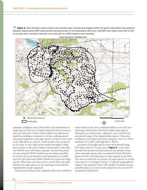
Chapter 3 • L<strong>and</strong>scape-Scale Wildl<strong>and</strong> Inventoriesq Figure 2. Daily inventory routes of each crew member were recorded <strong>and</strong> mapped within the project area (black line) using thebetween feature points (BFP, black points) tracking function of the GeoExplorer GPS units. Here BFP were taken every 500 ft (152m) to show that a surveyor had been in an area even if no NIS locations were recorded.maintain confidence that at least 90% of all infestations oftarget species 0.01 acre or larger within the entire inventoryarea were detected. Search swath widths were adjusted asneeded according to variations in terrain, walking speed,associated vegetation, <strong>and</strong> target species. In heavy cover <strong>and</strong>/or <strong>for</strong> difficult-to-see species, swath widths were as narrowas 25 yards. In very open terrain <strong>and</strong>/or <strong>for</strong> highly visiblespecies such as salt cedar (Tamarix ramosissima), some effectiveEDSWs were 100 yards or greater. <strong>Inventory</strong>ing steepterrain using the EDSW method was not always possible,so in that case crew members used binoculars to visuallyscan the open but inaccessible hillsides <strong>for</strong> suspected targetspecies. Binoculars were also used to search flats <strong>and</strong> washbottoms <strong>for</strong> target species in any openings surrounded byimpenetrable woody vegetation.Each inventoried area was assigned a detection confidencevalue based on the crew’s estimated ability to see 0.01-acre<strong>and</strong> larger infestations of the least visible target species,taking into account terrain, vegetation cover, <strong>and</strong> the size<strong>and</strong> growth stage of the targeted plant species. Detectionconfidence was broken into three categories: low (1 to 50%),medium (51 to 89%), <strong>and</strong> high (90 to 100%).Locations of all target species were documented usingGPS units with 2 to 5 m accuracy (Figure 3). Crews alsorecorded the location <strong>and</strong> documented the identity of anyother nontarget species they encountered if that NIS had aknown history of invasiveness in other regions in the West.The crew recorded the occurrence of target species on a hardcopy map (U.S. Geological <strong>Survey</strong> 7.5-minute topographicalmaps) in any situation where GPS satellite reception was notpossible (such as in narrow side canyons) or in cases of GPSequipment malfunction.28<strong>Inventory</strong> <strong>and</strong> <strong>Survey</strong> <strong>Methods</strong> <strong>for</strong> <strong>Nonindigenous</strong> <strong>Plant</strong> <strong>Species</strong>


