

Inventory and Survey Methods for Nonindigenous Plant Species (PDF)
Inventory and Survey Methods for Nonindigenous Plant Species (PDF)
Inventory and Survey Methods for Nonindigenous Plant Species (PDF)
- No tags were found...

You also want an ePaper? Increase the reach of your titles
YUMPU automatically turns print PDFs into web optimized ePapers that Google loves.
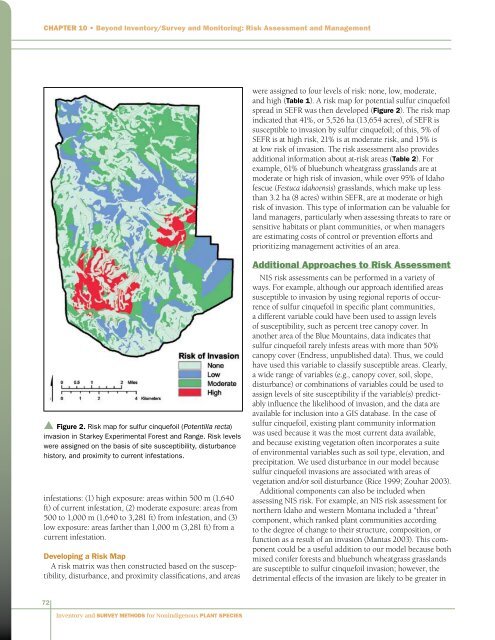
Chapter 10 • Beyond <strong>Inventory</strong>/<strong>Survey</strong> <strong>and</strong> Monitoring: Risk Assessment <strong>and</strong> Managementwere assigned to four levels of risk: none, low, moderate,<strong>and</strong> high (Table 1). A risk map <strong>for</strong> potential sulfur cinquefoilspread in SEFR was then developed (Figure 2). The risk mapindicated that 41%, or 5,526 ha (13,654 acres), of SEFR issusceptible to invasion by sulfur cinquefoil; of this, 5% ofSEFR is at high risk, 21% is at moderate risk, <strong>and</strong> 15% isat low risk of invasion. The risk assessment also providesadditional in<strong>for</strong>mation about at-risk areas (Table 2). Forexample, 61% of bluebunch wheatgrass grassl<strong>and</strong>s are atmoderate or high risk of invasion, while over 95% of Idahofescue (Festuca idahoensis) grassl<strong>and</strong>s, which make up lessthan 3.2 ha (8 acres) within SEFR, are at moderate or highrisk of invasion. This type of in<strong>for</strong>mation can be valuable <strong>for</strong>l<strong>and</strong> managers, particularly when assessing threats to rare orsensitive habitats or plant communities, or when managersare estimating costs of control or prevention ef<strong>for</strong>ts <strong>and</strong>prioritizing management activities of an area.▲ Figure 2. Risk map <strong>for</strong> sulfur cinquefoil (Potentilla recta)invasion in Starkey Experimental Forest <strong>and</strong> Range. Risk levelswere assigned on the basis of site susceptibility, disturbancehistory, <strong>and</strong> proximity to current infestations.infestations: (1) high exposure: areas within 500 m (1,640ft) of current infestation, (2) moderate exposure: areas from500 to 1,000 m (1,640 to 3,281 ft) from infestation, <strong>and</strong> (3)low exposure: areas farther than 1,000 m (3,281 ft) from acurrent infestation.Developing a Risk MapA risk matrix was then constructed based on the susceptibility,disturbance, <strong>and</strong> proximity classifications, <strong>and</strong> areasAdditional Approaches to Risk AssessmentNIS risk assessments can be per<strong>for</strong>med in a variety ofways. For example, although our approach identified areassusceptible to invasion by using regional reports of occurrenceof sulfur cinquefoil in specific plant communities,a different variable could have been used to assign levelsof susceptibility, such as percent tree canopy cover. Inanother area of the Blue Mountains, data indicates thatsulfur cinquefoil rarely infests areas with more than 50%canopy cover (Endress, unpublished data). Thus, we couldhave used this variable to classify susceptible areas. Clearly,a wide range of variables (e.g., canopy cover, soil, slope,disturbance) or combinations of variables could be used toassign levels of site susceptibility if the variable(s) predictablyinfluence the likelihood of invasion, <strong>and</strong> the data areavailable <strong>for</strong> inclusion into a GIS database. In the case ofsulfur cinquefoil, existing plant community in<strong>for</strong>mationwas used because it was the most current data available,<strong>and</strong> because existing vegetation often incorporates a suiteof environmental variables such as soil type, elevation, <strong>and</strong>precipitation. We used disturbance in our model becausesulfur cinquefoil invasions are associated with areas ofvegetation <strong>and</strong>/or soil disturbance (Rice 1999; Zouhar 2003).Additional components can also be included whenassessing NIS risk. For example, an NIS risk assessment <strong>for</strong>northern Idaho <strong>and</strong> western Montana included a “threat”component, which ranked plant communities accordingto the degree of change to their structure, composition, orfunction as a result of an invasion (Mantas 2003). This componentcould be a useful addition to our model because bothmixed conifer <strong>for</strong>ests <strong>and</strong> bluebunch wheatgrass grassl<strong>and</strong>sare susceptible to sulfur cinquefoil invasion; however, thedetrimental effects of the invasion are likely to be greater in72<strong>Inventory</strong> <strong>and</strong> <strong>Survey</strong> <strong>Methods</strong> <strong>for</strong> <strong>Nonindigenous</strong> <strong>Plant</strong> <strong>Species</strong>


