

Inventory and Survey Methods for Nonindigenous Plant Species (PDF)
Inventory and Survey Methods for Nonindigenous Plant Species (PDF)
Inventory and Survey Methods for Nonindigenous Plant Species (PDF)
- No tags were found...

Create successful ePaper yourself
Turn your PDF publications into a flip-book with our unique Google optimized e-Paper software.
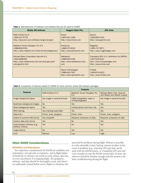
Chapter 4 • Digital Aerial Sketch-MappingTable 1. Manufacturers of hardware <strong>and</strong> software that can be used <strong>for</strong> DASM.Mobile GIS Software Rugged Tablet PCs GPS UnitsESRI ArcPad 6.0.31-800-447-9778http://www.esri.com/software/arcgis/arcpad/Itronix1-800-441-1309http://www.itronix.comGarmin1-800-800-1020http://www.garmin.comMapTech Terrain Navigator Pro 6.01-888-839-5551http://www.maptech.com/l<strong>and</strong>/terrainnavigatorpro/Panasonic1-888-270-5615http://www.panasonic.comMagellan1-800-707-9971http://www.magellangps.comMichael Baker Corporation GeoLink 6.11-800-MIBAKERhttp://www.mbakercorp.com/services/gis/products/geolink.htmlWalkabout1-888-925-5226http://www.walkabout-comp.comTransplant GPS (U.S. distributor <strong>for</strong> EMTAC)1-507-529-0041http://www.transplantgps.comhttp://www.emtac.comXplore Technologies1-888-449-7567http://www.xploretech.comTrimble1-800-874-6253http://www.trimble.comTable 2. Comparison of features helpful <strong>for</strong> DASM <strong>for</strong> three common mobile GIS software packages.FeaturesESRI ArcPad 6.0.3ProductsMapTech Terrain Navigator Pro6.0Image background layers Any image in several <strong>for</strong>mats USGS topographic maps ororthophotographsSeamless background images No Yes YesVector background layers Yes Limited–points <strong>and</strong> lines only YesGPS tracklog Yes–tracklog exportable Yes YesMichael Baker Corp. GeoLinkwith Raster <strong>and</strong> Sketch moduleAny image in several <strong>for</strong>matsData entry Points, lines, polygons Points, lines Points, lines, polygonsOutput to common GIS <strong>for</strong>mat Yes–shapefile Requires conversion of data Requires conversion of dataCustom data entry <strong>for</strong>ms Yes No YesCustomizable interface (e.g.,buttons, menus)Yes No YesLarge buttons No Yes YesCost Medium Low HighOther DASM ConsiderationsReliability <strong>and</strong> RedundancyTwo important considerations <strong>for</strong> DASM are reliability <strong>and</strong>redundancy. Aircraft time is expensive, <strong>and</strong> in-flight failureof hardware or software can result in costly delays, data loss,or even cancellation of a mapping flight. All equipment,software, <strong>and</strong> data should be thoroughly tested, <strong>and</strong> observerssufficiently trained be<strong>for</strong>e survey flights to minimize thepotential <strong>for</strong> problems during flight. Whenever possible,it is also advisable to have backup systems in place in theevent of problems (e.g., a backup GPS unit that can beused with the DASM system, or a h<strong>and</strong>held GPS unit <strong>and</strong>voice recorder in case the DASM system fails). At least oneobserver should be familiar enough with the system to dobasic troubleshooting during the flight.38<strong>Inventory</strong> <strong>and</strong> <strong>Survey</strong> <strong>Methods</strong> <strong>for</strong> <strong>Nonindigenous</strong> <strong>Plant</strong> <strong>Species</strong>


