

Inventory and Survey Methods for Nonindigenous Plant Species (PDF)
Inventory and Survey Methods for Nonindigenous Plant Species (PDF)
Inventory and Survey Methods for Nonindigenous Plant Species (PDF)
- No tags were found...

Create successful ePaper yourself
Turn your PDF publications into a flip-book with our unique Google optimized e-Paper software.
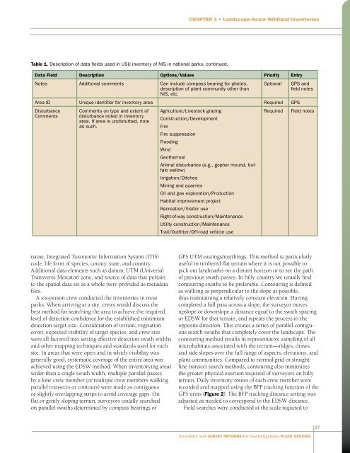
Chapter 3 • L<strong>and</strong>scape-Scale Wildl<strong>and</strong> InventoriesTable 1. Description of data fields used in USU inventory of NIS in national parks, continued.Data Field Description Options/Values Priority EntryNotes Additional comments Can include compass bearing <strong>for</strong> photos,description of plant community other thanNIS, etc.OptionalArea ID Unique identifier <strong>for</strong> inventory area Required GPSDisturbanceCommentsComments on type <strong>and</strong> extent ofdisturbance noted in inventoryarea. If area is undisturbed, noteas such.Agriculture/Livestock grazingConstruction/DevelopmentFireFire suppressionFloodingWindGeothermalAnimal disturbance (e.g., gopher mound, buffalowallow)Irrigation/DitchesMining <strong>and</strong> quarriesOil <strong>and</strong> gas exploration/ProductionHabitat improvement projectRecreation/Visitor useRight-of-way construction/MaintenanceUtility construction/MaintenanceTrail/Outfitter/Off-road vehicle useRequiredGPS <strong>and</strong>field notesField notesname, Integrated Taxonomic In<strong>for</strong>mation System (ITIS)code, life <strong>for</strong>m of species, county, state, <strong>and</strong> country.Additional data elements such as datum, UTM (UniversalTransverse Mercator) zone, <strong>and</strong> source of data that pertainto the spatial data set as a whole were provided as metadatafiles.A six-person crew conducted the inventories in mostparks. When arriving at a site, crews would discuss thebest method <strong>for</strong> searching the area to achieve the requiredlevel of detection confidence <strong>for</strong> the established minimumdetection target size. Consideration of terrain, vegetationcover, expected visibility of target species, <strong>and</strong> crew sizewere all factored into setting effective detection swath widths<strong>and</strong> other mapping techniques <strong>and</strong> st<strong>and</strong>ards used <strong>for</strong> eachsite. In areas that were open <strong>and</strong> in which visibility wasgenerally good, systematic coverage of the entire area wasachieved using the EDSW method. When inventorying areaswider than a single swath width, multiple parallel passesby a lone crew member (or multiple crew members walkingparallel transects or contours) were made as contiguousor slightly overlapping strips to avoid coverage gaps. Onflat or gently sloping terrain, surveyors usually searchedon parallel swaths determined by compass bearings orGPS UTM eastings/northings. This method is particularlyuseful in timbered flat terrain where it is not possible topick out l<strong>and</strong>marks on a distant horizon or to see the pathof previous swath passes. In hilly country we usually findcontouring swaths to be preferable. Contouring is definedas walking as perpendicular to the slope as possible,thus maintaining a relatively constant elevation. Havingcompleted a full pass across a slope, the surveyor movesupslope or downslope a distance equal to the swath spacingor EDSW <strong>for</strong> that terrain, <strong>and</strong> repeats the process in theopposite direction. This creates a series of parallel contiguoussearch swaths that completely cover the l<strong>and</strong>scape. Thecontouring method results in representative sampling of allmicrohabitats associated with the terrain—ridges, draws,<strong>and</strong> side slopes over the full range of aspects, elevations, <strong>and</strong>plant communities. Compared to normal grid or straightlinetransect search methods, contouring also minimizesthe greater physical exertion required of surveyors on hillyterrain. Daily inventory routes of each crew member wererecorded <strong>and</strong> mapped using the BFP tracking function of theGPS units (Figure 2). The BFP tracking distance setting wasadjusted as needed to correspond to the EDSW distance.Field searches were conducted at the scale required to27<strong>Inventory</strong> <strong>and</strong> <strong>Survey</strong> <strong>Methods</strong> <strong>for</strong> <strong>Nonindigenous</strong> <strong>Plant</strong> <strong>Species</strong>


