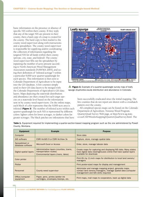
Chapter 9 • Coarse-Scale Mapping: The Section or Quadrangle-based Methodbasic in<strong>for</strong>mation on the presence or absence ofspecific NIS within their county. If they replythat any of the target NIS are present in theircounty, then a hard copy of a map is created <strong>for</strong>the county. The hard copy is then mailed to thecounty weed supervisor along with instructions<strong>and</strong> a spreadsheet. The county weed supervisoris responsible <strong>for</strong> supplying <strong>and</strong>/or coordinatingthe collection of in<strong>for</strong>mation regarding thetargeted NIS <strong>for</strong> all l<strong>and</strong>s within their county(private, city, state, <strong>and</strong> federal). The countyweed supervisor fills out the spreadsheet byinputting the number of acres present (accordingto North American Weed ManagementAssociation st<strong>and</strong>ards [NAWMA 2003], <strong>and</strong> usingtheir definition of “infested acreage”) withina particular 9,000-acre quarter-quadrangle <strong>for</strong>each species. This in<strong>for</strong>mation is then sent toColorado Department of Agriculture to be inputinto the GIS database. A few counties simplysend in their GIS data layers to be merged withthe Colorado Department of Agriculture’s GIS datalayers. Maps depicting the statewide distribution<strong>and</strong> abundance are then created <strong>for</strong> each target specieson a statewide level based on the in<strong>for</strong>mationsent in by county weed supervisors. On the online maps,each block of color represents that the 9,000-acre area isinfested (Figure 3). The number of infested acres within eachquarter-quadrangle <strong>for</strong> each NIS is represented by differentcolors: lighter colors <strong>for</strong> lower acreages, to darker colors <strong>for</strong>greater acreages. The black patches are infestations that havebeen successfully eradicated since the initial mapping. Thefew counties that do not report are shown with a crosshatchpattern over the county.All completed species maps can be found on the ColoradoDepartment of Agriculture, Noxious Weed Program,QuarterQuad <strong>Survey</strong> Web page, at http://www.ag.state.co.us/CSD/Weeds/mapping/QuarterQuad<strong>Survey</strong>.html. TheTable 1. Equipment required <strong>for</strong> implementing a quarter-section-based mapping program such as the one administered by PowellCounty, Montana.Equipment Example PurposeComputerStore dataGIS software ESRI ArcGIS 9 or ESRI ArcView 3x Capture, store, manage spatial dataSpreadsheet ordatabase softwareDigital spatial layersColor printerPlotterPersonnelOffice/computerequipmentMicrosoft Excel or AccessAdministrative layers (counties, towns,transportation routes)Environmental layers (rivers, lakes)County weed supervisorPaper, pens, printer/plotter inkcartridges, envelopes/stamps, etc.▲ Figure 3. Example of a quarter-quadrangle survey map of leafyspurge (Euphorbia esula) distribution <strong>and</strong> abundance in Colorado.Enter, store, manage tabular dataCreate maps <strong>for</strong> capturing <strong>and</strong> displaying NIS data. Many stateshave digital data clearinghouses online that have spatial layersavailable <strong>for</strong> download.Print 8½ by 11-inch maps <strong>for</strong> distribution to local l<strong>and</strong> owners/managersPrint poster-sized maps <strong>for</strong> display <strong>and</strong> managementAdminister <strong>and</strong> manage mapping project, generate maps,contact l<strong>and</strong> owners/managers, manage spatial data (computermanagement <strong>and</strong> GIS skills required)Print maps, mail maps to cooperators, back up digital data68<strong>Inventory</strong> <strong>and</strong> <strong>Survey</strong> <strong>Methods</strong> <strong>for</strong> <strong>Nonindigenous</strong> <strong>Plant</strong> <strong>Species</strong>
Chapter 9 • Coarse-Scale Mapping: The Section or Quadrangle-based Method1999 Section-Based Map Leafy Spurgep Figure 4. Montana Department of Agriculture section-based map ofleafy spurge (Euphorbia esula).2002, 2004, <strong>and</strong> 2005 GIS datasets can also be downloadedfrom that Web page. (The QuarterQuad <strong>Survey</strong> page is bestviewed in Internet Explorer.)Equipment NeededIf there is no existing state- or agency-led initiative toper<strong>for</strong>m <strong>and</strong> store coarse-scale mapping data, establishing aprogram from scratch requires a relatively simple combinationof personnel <strong>and</strong> equipment. The basic equipmentrequired to implement a coarse-scale mapping programincludes computer hardware <strong>and</strong> software, digital spatiallayers <strong>for</strong> creating maps, a color printer or plotter, trainedpersonnel, <strong>and</strong> miscellaneous office equipment. Table 1details a more specific list of essential equipment. If anobjective is to make the data available on the Internet,additional software is required as well as a secure networkconnection, computer server, Internet map server software,<strong>and</strong> trained in<strong>for</strong>mation technology <strong>and</strong> systems analysissupport.Advantages <strong>and</strong> Disadvantages ofCoarse-Scale MappingCoarse-scale mapping is a time- <strong>and</strong> cost-effective method<strong>for</strong> obtaining an approximate picture of NIS distribution<strong>and</strong> abundance over large <strong>and</strong> jurisdictionally complexareas such as counties, national <strong>for</strong>ests, <strong>and</strong> states. Further,coarse-scale maps span multiple management boundaries<strong>and</strong> l<strong>and</strong>scapes, allowing l<strong>and</strong>owners <strong>and</strong> managersto develop shared management objectives <strong>and</strong>coordinate nonindigenous plant managementef<strong>for</strong>ts over large areas. For example, section-basedmaps <strong>for</strong> five NIS were included in the MontanaWeed Management Plan (Weed Summit SteeringCommittee <strong>and</strong> Weed Management Task Force2001), <strong>and</strong> Figure 4 illustrates distribution of leafyspurge in Montana.Mapping at coarse scales such as mile-square(640-acre) or quarter-quadrangle (9,000-acre)grid cells is based on l<strong>and</strong>owners’ <strong>and</strong> managers’knowledge of the l<strong>and</strong>. Consequently, it ismuch less detailed than ground-based <strong>and</strong> othermapping methods, <strong>and</strong> even at the coarse scalecollected, it is potentially inaccurate becauseit is very dependent on the identification <strong>and</strong>memory skills of the people involved. However,the advantage is that maps can be made of theprobable occurrence of NIS over large areas ofl<strong>and</strong>, <strong>and</strong> depending on the approach taken,the relative location (presence within the gridor minimum mapping unit) <strong>and</strong> estimates of infestedacreage can be compiled quite quickly <strong>and</strong> inexpensively.For example, it takes only two weeks <strong>for</strong> Powell County toupdate their maps. The coarse-scale maps can also be usedto monitor, in the broadest sense, spread or loss (eradication)of target NIS over the area of interest. However, coarse-scalemapping does not provide exact acreages (size) or correlationwith environmental variables. There<strong>for</strong>e, coarse-scale mapsare not appropriate <strong>for</strong> site-specific management or as a tool<strong>for</strong> analyzing invasion biology <strong>and</strong> processes.AcknowledgementsWe would like to thank Jason Smith, Powell County WeedCoordinator, <strong>for</strong> his valuable comments on this chapter.ReferencesColorado Department of Agriculture. 2005. 2002 <strong>and</strong> 2004 QuarterQuad<strong>Survey</strong>. http://www.ag.state.co.us/DPI/NIS/mapping/Quarterquad<strong>Survey</strong>.html.Cooksey, D. <strong>and</strong> R. L. Sheley. 1998 (revised 2001). Mapping Montana’sNoxious Weeds. Bozeman, MT: Montana State University Extension EB148. 20 p.[NAWMA] North American Weed Management Association. 2003. NorthAmerican Invasive <strong>Plant</strong> Mapping St<strong>and</strong>ards. http://www.nawma.org/.Weed Summit Steering Committee <strong>and</strong> Weed Management Task Force.2001. The Montana Weed Management Plan. Helena, MT: MontanaDepartment of Agriculture. 96 pp. http://www.mtweed.org/News/the_weed_plan.pdf.<strong>Inventory</strong> <strong>and</strong> <strong>Survey</strong> <strong>Methods</strong> <strong>for</strong> <strong>Nonindigenous</strong> <strong>Plant</strong> <strong>Species</strong>69