Adaptive Sampling DesignChapter 7Timothy S. PratherBackgroundIncreased global trade has great potential <strong>for</strong> bringingnew plant species to our doorstep (Mack <strong>and</strong> Lonsdale2001), some of which may disperse <strong>and</strong> establish,usually along transportation routes (MacDonald et al.1989). Because an increase in nonindigenous plantspecies (NIS) in an area is related to the density ofroads in that area (Kalin et al. 2000), conducting anNIS inventory/survey biased towards roads makessense. Rivers <strong>and</strong> streams are also important to plantmovement (Nilsson et al. 2002; Parendes <strong>and</strong> Jones(2000). However, wind-dispersed plant species <strong>and</strong>species dispersed by birds will have less associationwith roads, trails, <strong>and</strong> rivers. The seeds of winddispersedspecies such as Russian thistle (Salsolaiberica) may move as little as 60 m <strong>and</strong> as much as 4km, depending on wind speed <strong>and</strong> duration (Stallingset al. 1995). Topography <strong>and</strong> thermal updrafts wereconsidered more important than wind speed in astudy involving mouse-ear hawkweed (Hieraciumpilosella) dispersal. As topographic relief increased,thermal updrafts increased in strength, resulting inlong-distance dispersal of at least 250 m (Tackenberg2003). Dispersal by birds is not as likely to be relatedto road <strong>and</strong> trail systems, but rather to perches suchas fencerows. For example, dispersal of seeds byhornbills in tropical West Africa measured 1.1 to 2.0km on average, with maximal distances of up to 6.9 km(Tackenberg 2003).A strategy <strong>for</strong> NIS survey that focuses on transportationroutes should increase the efficiency of the survey,especially as the size of the area managed increases.Furthermore, when rivers <strong>and</strong> streams are in proximityto roads or trails, areas downstream from infestationsshould be examined. Because a survey biased towardtransportation routes may not accurately assessspecies dispersed by wind or birds, transects perpendicularto the transportation route should be included.ObjectiveAreas of disturbance <strong>and</strong> human activity (roads, trails,etc.) provide both the conditions <strong>and</strong> the opportunity<strong>for</strong> NIS establishment. The adaptive sampling methodprioritizes areas to survey by focusing on roads, trails,campgrounds, <strong>and</strong> waterways. Biasing the survey to areasmore likely to contain NIS improves efficiency, much likeusing a stratified sampling technique increases samplingefficiency. The primary objective of adaptive survey is toefficiently sample areas <strong>for</strong> NIS, particularly areas with littleor no prior inventory/survey data. An additional objectiveis to record all the areas sampled, rather than just locationsof NIS. Knowledge of areas where NIS do not reside is ofconsiderable importance <strong>for</strong> management <strong>and</strong> these data areuseful to better underst<strong>and</strong> the potential distribution of anNIS.MethodThe adaptive sampling method presented in this chapteruses areas of human activity as a starting point. Forexample, the starting point may be a trail, campground,or beaching area <strong>for</strong> rafts. The area is then traversed, <strong>and</strong>lack of NIS are recorded until a target NIS is located. Oncea target NIS is located, the crew spaces themselves at twicethe detection distance (Figure 1) of the targeted species. Thecrew then moves away from the known location into thesurrounding area, either in concentric circles in gentle terrain,or by walking the elevational contour from the knownlocation. As the target NIS are found, the survey crewcontinues away from the new individual/patch, in circles oron contours, until no target NIS are found <strong>for</strong> a predefineddistance.NIS are mapped as point features <strong>and</strong> the radius of thepopulation is recorded. If infestations are large (radiusgreater than 40 m) <strong>and</strong> irregularly shaped, the perimeter ofthe infestation is walked <strong>and</strong> recorded directly as a polygon.NIS populations are recorded as separate points or polygonsif 20 to 40 m separate the individual plants or patches. Theseparation distance between patches is defined be<strong>for</strong>e thesurvey begins <strong>and</strong> depends on the visibility of the targetedspecies. Identifying every plant is not important; rather, it isimportant to identify the outer boundary of the infestation.The outer boundary is considered to be located when notarget NIS have been found <strong>for</strong> 400 m (species not winddispersed) or 800 m (wind-dispersed species). A surveydistance of 800 m has been adopted <strong>for</strong> wind-dispersedspecies such as hawkweeds (Hieracium spp.) because surveycrews have found that wind-dispersed species could befound up to 650 m from the last known plant. The radiusdata <strong>for</strong> each population is used later within the geographicin<strong>for</strong>mation system (GIS) software to extend points tocircular polygons to represent the size of each infestation.Perpendicular TransectsOnce an outer boundary of an adaptive survey is determined(i.e., no target NIS have been recorded <strong>for</strong> 400 to 800m depending on dispersal type), the survey crew returns tothe trail (or other area of interest) <strong>and</strong> continues to survey.If NIS are not found <strong>for</strong> the next 4 km, a transect is taken56<strong>Inventory</strong> <strong>and</strong> <strong>Survey</strong> <strong>Methods</strong> <strong>for</strong> <strong>Nonindigenous</strong> <strong>Plant</strong> <strong>Species</strong>
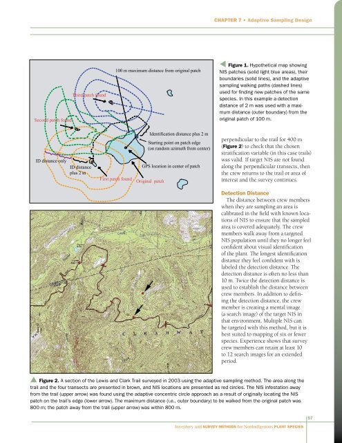
Chapter 7 • Adaptive Sampling DesignSecond patch found}}ID distance onlyThird patch found}ID distanceplus 2 m100 m maximum distance from original patch100 mFirst patch found}Identification distance plus 2 mStarting Original point on patch patch edge(on r<strong>and</strong>om azimuth from center)GPS locationGPS location in center of patchOriginal patcht Figure 1. Hypothetical map showingNIS patches (solid light blue areas), theirboundaries (solid lines), <strong>and</strong> the adaptivesampling walking paths (dashed lines)used <strong>for</strong> finding new patches of the samespecies. In this example a detectiondistance of 2 m was used with a maximumdistance (outer boundary) from theoriginal patch of 100 m.perpendicular to the trail <strong>for</strong> 400 m(Figure 2) to check that the chosenstratification variable (in this case trails)was valid. If target NIS are not foundalong the perpendicular transects, thenthe crew returns to the trail or area ofinterest <strong>and</strong> the survey continues.Detection DistanceThe distance between crew memberswhen they are sampling an area iscalibrated in the field with known locationsof NIS to ensure that the sampledarea is covered adequately. The crewmembers walk away from a targetedNIS population until they no longer feelconfident about visual identificationof the plant. The longest identificationdistance they feel confident with islabeled the detection distance. Thedetection distance is often no less than10 m. Twice the detection distance isused to establish the distance betweencrew members. In addition to definingthe detection distance, the crewmember is creating a mental image(a search image) of the target NIS inthat environment. Multiple NIS canbe targeted with this method, but it isbest suited to mapping of six or fewerspecies. Experience shows that surveycrew members can retain at least 10to 12 search images <strong>for</strong> an extendedperiod.▲ Figure 2. A section of the Lewis <strong>and</strong> Clark Trail surveyed in 2003 using the adaptive sampling method. The area along thetrail <strong>and</strong> the four transects are presented in brown, <strong>and</strong> NIS locations are presented as red circles. The NIS infestation awayfrom the trail (upper arrow) was found using the adaptive concentric circle approach as a result of originally locating the NISpatch on the trail’s edge (lower arrow). The maximum distance (i.e., outer boundary) to be walked from the original patch was800 m; the patch away from the trail (upper arrow) was within 800 m.<strong>Inventory</strong> <strong>and</strong> <strong>Survey</strong> <strong>Methods</strong> <strong>for</strong> <strong>Nonindigenous</strong> <strong>Plant</strong> <strong>Species</strong>57