Tiered Sampling Method: Nevada’s ProtocolChapter 5Robert E. Wilson, Ted Angle, <strong>and</strong> Maria RyanIntroductionNevada is a region primarily of large l<strong>and</strong>scapes withfew towns or people. Detecting nonindigenous plantspecies (NIS) in these vast l<strong>and</strong>scapes is problematic.Although there are places where NIS may predictablybe found (e.g., roadways, waterways, disturbed areas),it is important that NIS be detected in more nonpredictableareas (e.g., <strong>for</strong>ests, grassl<strong>and</strong>s) as well. The tieredsampling method provides an approach to locating <strong>and</strong>recording infestations that has proven effective <strong>and</strong>efficient. The method employs three tiers to enablel<strong>and</strong> managers to locate NIS in both predictable <strong>and</strong>nonpredictable situations with a reasonable degree ofaccuracy <strong>and</strong> reliability.ObjectivesThe primary goal of the tiered sampling method is todetect <strong>and</strong> map the location, density, <strong>and</strong> spatial extent ofspecific established populations of nonindigenous plant specieswithin the area of interest. The tiered sampling methodis being used to map most of the state of Nevada’s noxiousweed species, <strong>and</strong> this is the example presented throughoutthis chapter.The term survey is defined here as an investigation of anarea using a sampling method to obtain an estimate of theNIS populations. Not every square yard is observed in thesurvey sampling process. In<strong>for</strong>mation gathered through thesampling is extrapolated to unsurveyed areas. Elsewhere inthis chapter, the term inventory is used to reflect an intensiveviewing of an area in order to gain an accurate underst<strong>and</strong>ingof the NIS population over the entire area. The methoddescribed in Tier I is considered in this chapter to be aninventory, while Tier II <strong>and</strong> III methods are considered tobe surveys. Thus, the inventory/survey terms are used inaccordance with the definitions in Chapter 1.Managers need to know which NIS are problems, <strong>and</strong>where they are, be<strong>for</strong>e they plan strategies of control or containment,<strong>and</strong> to avoid actions which would make the NISproblem more severe. The U.S. Bureau of L<strong>and</strong> ManagementEly Field Office Resource Management Plan/EnvironmentalImpact Statement <strong>for</strong> the Ely District (available from theEly Field Office, 775-289-1880) provides an example of theneed <strong>for</strong> knowledge about noxious weed populations be<strong>for</strong>emanagement activities are implemented. However, it is obviouslyimpossible to devote adequate resources to inventoryall noxious weed populations, let alone all NIS populations,over very large l<strong>and</strong>scapes. In Nevada noxious weeds are thetarget of the sampling protocol. The sampling protocol usesa tiered approach to prioritize inventory/survey locations<strong>and</strong> to ensure with some degree of accuracy that most ofthe target species populations will be located. Based on thepremise that disturbed areas are the most likely places <strong>for</strong>the target populations to occur or become established, TierI inventories are directed toward disturbed or wet areas(e.g., along transportation systems, <strong>and</strong> around waterwaysor water bodies). The second tier surveys occur in areaswith limited disturbance that are presumably less probablesites <strong>for</strong> NIS invasion. Thus, Tier II surveys are per<strong>for</strong>medto locate target species infestations that might have beeninadvertently introduced by other means (e.g., livestock,wildlife, humans) into remote <strong>and</strong>/or undisturbed areas. Thethird tier is a r<strong>and</strong>om check to validate the reliability of theinventory <strong>and</strong> survey completed in the first <strong>and</strong> second tiers.Essentially, Tier I is an inventory because all disturbed areasare sampled, while Tiers II <strong>and</strong> III are surveys because theyare subsamples of the whole area. Regardless of the tier level,when a target area is defined the whole area is sampled.This multitiered approach is designed to ensure a highlevel of accuracy, reliability, <strong>and</strong> repeatability across thel<strong>and</strong>scape. In Nevada this approach provides greater than90% confidence that all noxious weed infestations have beenfound. The data should be added to a central geographicin<strong>for</strong>mation system (GIS). Once target NIS populations havebeen located, control or management ef<strong>for</strong>ts can begin.In<strong>for</strong>mation on these ef<strong>for</strong>ts should also be added to the GIS,<strong>and</strong> some of the populations monitored. Such field collectionof data <strong>and</strong> record keeping allow <strong>for</strong> evaluation of the control<strong>and</strong> management effectiveness.Using the tiered approach means that the inventory/surveycan be tailored to meet a variety of different l<strong>and</strong> use <strong>and</strong>inventory/survey objectives, <strong>and</strong> can be adjusted accordingto constraints such as funding, area, <strong>and</strong>/or desired accuracy,as described in Chapter 1. For example, managers maybe interested in finding as many NIS patches as possibleso they can be eradicated from an area, or they may need ageneral assessment of NIS present in a large area. The followingsection on planning includes a series of questions asurveyor using the tiered method will need to address at thestart of the inventory/survey so that the sampling protocolcan be adjusted accordingly. If the method is modified; i.e.,if one or more tiers are removed from the protocol, thenthe confidence level will decline significantly. Managementof NIS populations is separate from the inventory/surveymethodology.MethodPlanningThe inventory/survey protocol presented was developedin east-central Nevada in the Tri-County Program <strong>and</strong> has42<strong>Inventory</strong> <strong>and</strong> <strong>Survey</strong> <strong>Methods</strong> <strong>for</strong> <strong>Nonindigenous</strong> <strong>Plant</strong> <strong>Species</strong>
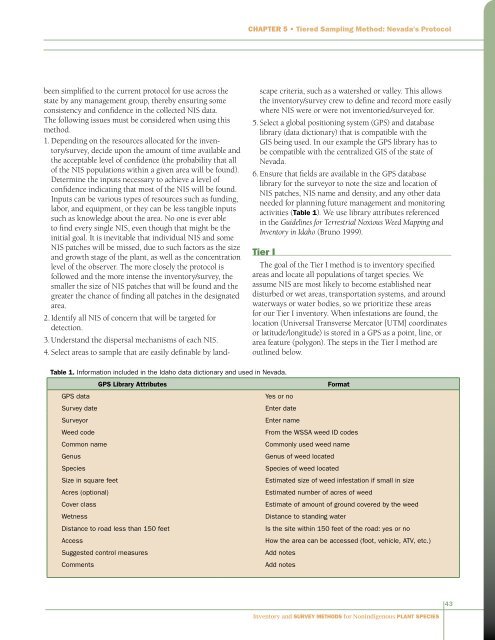
Chapter 5 • Tiered Sampling Method: Nevada’s Protocolbeen simplified to the current protocol <strong>for</strong> use across thestate by any management group, thereby ensuring someconsistency <strong>and</strong> confidence in the collected NIS data.The following issues must be considered when using thismethod.1. Depending on the resources allocated <strong>for</strong> the inventory/survey,decide upon the amount of time available <strong>and</strong>the acceptable level of confidence (the probability that allof the NIS populations within a given area will be found).Determine the inputs necessary to achieve a level ofconfidence indicating that most of the NIS will be found.Inputs can be various types of resources such as funding,labor, <strong>and</strong> equipment, or they can be less tangible inputssuch as knowledge about the area. No one is ever ableto find every single NIS, even though that might be theinitial goal. It is inevitable that individual NIS <strong>and</strong> someNIS patches will be missed, due to such factors as the size<strong>and</strong> growth stage of the plant, as well as the concentrationlevel of the observer. The more closely the protocol isfollowed <strong>and</strong> the more intense the inventory/survey, thesmaller the size of NIS patches that will be found <strong>and</strong> thegreater the chance of finding all patches in the designatedarea.2. Identify all NIS of concern that will be targeted <strong>for</strong>detection.3. Underst<strong>and</strong> the dispersal mechanisms of each NIS.4. Select areas to sample that are easily definable by l<strong>and</strong>scapecriteria, such as a watershed or valley. This allowsthe inventory/survey crew to define <strong>and</strong> record more easilywhere NIS were or were not inventoried/surveyed <strong>for</strong>.5. Select a global positioning system (GPS) <strong>and</strong> databaselibrary (data dictionary) that is compatible with theGIS being used. In our example the GPS library has tobe compatible with the centralized GIS of the state ofNevada.6. Ensure that fields are available in the GPS databaselibrary <strong>for</strong> the surveyor to note the size <strong>and</strong> location ofNIS patches, NIS name <strong>and</strong> density, <strong>and</strong> any other dataneeded <strong>for</strong> planning future management <strong>and</strong> monitoringactivities (Table 1). We use library attributes referencedin the Guidelines <strong>for</strong> Terrestrial Noxious Weed Mapping <strong>and</strong><strong>Inventory</strong> in Idaho (Bruno 1999).Tier IThe goal of the Tier I method is to inventory specifiedareas <strong>and</strong> locate all populations of target species. Weassume NIS are most likely to become established neardisturbed or wet areas, transportation systems, <strong>and</strong> aroundwaterways or water bodies, so we prioritize these areas<strong>for</strong> our Tier I inventory. When infestations are found, thelocation (Universal Transverse Mercator [UTM] coordinatesor latitude/longitude) is stored in a GPS as a point, line, orarea feature (polygon). The steps in the Tier I method areoutlined below.Table 1. In<strong>for</strong>mation included in the Idaho data dictionary <strong>and</strong> used in Nevada.GPS Library AttributesGPS data<strong>Survey</strong> date<strong>Survey</strong>orWeed codeCommon nameGenus<strong>Species</strong>Size in square feetAcres (optional)Cover classWetnessDistance to road less than 150 feetAccessSuggested control measuresCommentsFormatYes or noEnter dateEnter nameFrom the WSSA weed ID codesCommonly used weed nameGenus of weed located<strong>Species</strong> of weed locatedEstimated size of weed infestation if small in sizeEstimated number of acres of weedEstimate of amount of ground covered by the weedDistance to st<strong>and</strong>ing waterIs the site within 150 feet of the road: yes or noHow the area can be accessed (foot, vehicle, ATV, etc.)Add notesAdd notes43<strong>Inventory</strong> <strong>and</strong> <strong>Survey</strong> <strong>Methods</strong> <strong>for</strong> <strong>Nonindigenous</strong> <strong>Plant</strong> <strong>Species</strong>