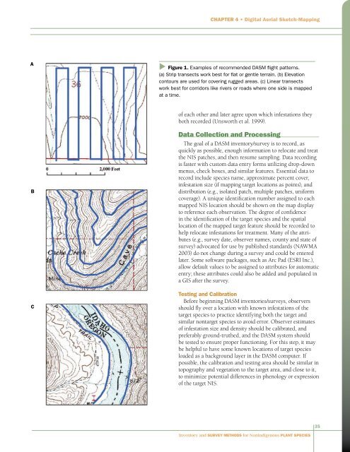
Chapter 4 • Digital Aerial Sketch-Mapping(1999) suggest that subunits that take about one hour tosample are efficient <strong>and</strong> allow adequate breaks <strong>for</strong> observers.Subunits should be defined by features easily recognizedfrom the air (such as ridge tops, streams or rivers, <strong>and</strong>roads), but not by impermanent features such as fence linesor vegetation boundaries. Subunit boundaries should beloaded as a background layer on the DASM computer. Tosample subunits completely be<strong>for</strong>e moving on, the pilotshould be in<strong>for</strong>med of subunit boundaries. Progress insampling subunits can also be tracked with the tracklogfeature of the global positioning system/geographic in<strong>for</strong>mationsystem (GPS/GIS).Subunits may be considered as statistical stratificationsof the survey area, particularly if they are based on featuresthought to be significant to the distribution of the targetNIS. Otherwise, they should be considered subdivisions ofthe survey area only <strong>for</strong> efficiency <strong>and</strong> tracking purposes. IfNIS population changes are to be monitored using methodsof estimating populations from aerial mapping (see Pollock<strong>and</strong> Kendall 1987), subsequent surveys must be flown withthe same subunits <strong>and</strong> pixel resolution as the original survey(Unsworth et al. 1999).Aircraft <strong>and</strong> Flight PatternsDigital aerial sketch-mapping can be flown from eitheran airplane or a helicopter. Airplanes are less expensive perhour than helicopters <strong>and</strong> may be adequate <strong>for</strong> samplinglarge infestations of easily visible NIS or in flat or gentleterrain. However, the minimum speed of 70 to 80 miles perhour <strong>for</strong> most small fixed-wing airplanes may be too fast<strong>for</strong> NIS surveys. At that speed, unless the map display iszoomed out, the GPS cursor indicating current position willfrequently move off the screen, <strong>for</strong>cing the map display toredraw. Additionally, limitations on how close to the grounda fixed-wing airplane can safely fly may induce error in thelocation of infestations sketched on the map display.Helicopters are much more expensive to use than airplanes,but may be more suitable <strong>for</strong> DASM. Sampling speedis variable with a helicopter, although wind <strong>and</strong> site (e.g.,topography) conditions may require that a minimum speedbe maintained <strong>for</strong> safe operation. Helicopters also offer muchgreater flexibility in the altitude above ground level at whichsampling can be conducted.Since both inventories <strong>and</strong> surveys assume subunits arecanvassed completely, flight patterns must allow all parts ofthe subunits to be seen. Unsworth et al. (1999) recommendthat subunits with minimal topographic relief be flown instrip transects <strong>and</strong> those with rugged topography be flownalong elevation contours. They further recommend thatcontours or transects be 300 ft (91.4 m) or less apart indense vegetation or in gentle terrain, <strong>and</strong> up to 500 ft (152.4m) apart in rugged, open areas (Figure 1). Observers shouldmake sure not to overlook the edges of subunits. In samplingriver banks, wide riparian areas, or other linear habitats, wehave found it useful to view one side at a time.Altitude above ground level (AGL) <strong>and</strong> flight speed bothaffect the observer’s effective sight distance. Altitudes of 100to 150 feet (30.5 to 45.7 m) AGL are recommended <strong>for</strong> biggame surveys (Unsworth et al. 1999); our 2004 trial surveyswere flown at altitudes of 30 to 100 feet (9.1 to 30.5 m) AGL.Helicopter speeds of 40 to 50 miles per hour (64.4 to 80.5kilometers per hour) are recommended <strong>for</strong> big game surveys(Unsworth et al. 1999), but in NIS inventory/survey, slowerspeeds may be required <strong>for</strong> hard-to-detect species or smallpatches.ObserversIdeally, two observers should view <strong>and</strong> record targetNIS in the same areas at the same time, with one observerdesignated as primary. Double observers provide backup ifone system fails, <strong>and</strong> can take advantage of methods used toestimate population sizes (Pollock <strong>and</strong> Kendall 1987) <strong>and</strong>the proportion of plants or patches missed by the primaryobserver. If one DASM system <strong>and</strong> one traditional GPS/voicerecorder system are being used, the primary observershould record on the DASM system <strong>and</strong> the second on theGPS/voice-recorded system.Observers must be proficient in the chosen mobile GISsoftware; otherwise, data may be inaccurate, incomplete, oreven lost. They should practice collecting data on the ground<strong>and</strong>/or be trained by experienced observers be<strong>for</strong>e conductingDASM surveys alone. Observers should also be familiarenough with the configuration of the DASM system <strong>and</strong> thedata used to troubleshoot basic problems while in flight.DASM <strong>Methods</strong>Digital aerial sketch-mapping methods are straight<strong>for</strong>ward.The aircraft enters a subunit, the pilot flies accordingto a predetermined flight pattern, <strong>and</strong> the observers look<strong>for</strong> <strong>and</strong> record NIS from both sides of the aircraft. Mostaerial survey methods assume that all or most infestationsnear the observer are recorded, <strong>and</strong> that the probability ofdetection decreases with distance from the observer (Pollock<strong>and</strong> Kendall 1987). However, since it is possible to missseeing areas close to <strong>and</strong> directly below the aircraft, specialattention is required so that infestations in such areas are notmissed. When an infestation is seen, the observer identifiesits ground location on the DASM map display <strong>and</strong>, using thestylus, draws the infestation on the map <strong>and</strong> fills in the attributedata be<strong>for</strong>e resuming the survey. If the survey resultsare to be used <strong>for</strong> estimating population sizes or proportionsof infestations missed, observers must sample independently34<strong>Inventory</strong> <strong>and</strong> <strong>Survey</strong> <strong>Methods</strong> <strong>for</strong> <strong>Nonindigenous</strong> <strong>Plant</strong> <strong>Species</strong>
Chapter 4 • Digital Aerial Sketch-MappingAu Figure 1. Examples of recommended DASM flight patterns.(a) Strip transects work best <strong>for</strong> flat or gentle terrain. (b) Elevationcontours are used <strong>for</strong> covering rugged areas. (c) Linear transectswork best <strong>for</strong> corridors like rivers or roads where one side is mappedat a time.of each other <strong>and</strong> later agree upon which infestations theyboth recorded (Unsworth et al. 1999).BCData Collection <strong>and</strong> ProcessingThe goal of a DASM inventory/survey is to record, asquickly as possible, enough in<strong>for</strong>mation to relocate <strong>and</strong> treatthe NIS patches, <strong>and</strong> then resume sampling. Data recordingis faster with custom data entry <strong>for</strong>ms utilizing drop-downmenus, check boxes, <strong>and</strong> similar features. Essential data torecord include species name, approximate percent cover,infestation size (if mapping target locations as points), <strong>and</strong>distribution (e.g., isolated patch, multiple patches, uni<strong>for</strong>mcoverage). A unique identification number assigned to eachmapped NIS location should be shown on the map displayto reference each observation. The degree of confidencein the identification of the target species <strong>and</strong> the spatiallocation of the mapped target feature should be recorded tohelp relocate infestations <strong>for</strong> treatment. Many of the attributes(e.g., survey date, observer names, county <strong>and</strong> state ofsurvey) advocated <strong>for</strong> use by published st<strong>and</strong>ards (NAWMA2003) do not change during a survey <strong>and</strong> could be enteredlater. Some software packages, such as Arc Pad (ESRI Inc.),allow default values to be assigned to attributes <strong>for</strong> automaticentry; these attributes could also be added <strong>and</strong> populated ina GIS after the survey.Testing <strong>and</strong> CalibrationBe<strong>for</strong>e beginning DASM inventories/surveys, observersshould fly over a location with known infestations of thetarget species to practice identifying both the target <strong>and</strong>similar nontarget species to avoid error. Observer estimatesof infestation size <strong>and</strong> density should be calibrated, <strong>and</strong>preferably ground-truthed, <strong>and</strong> the DASM system shouldbe tested to ensure proper functioning. For this step, it maybe helpful to have some known locations of target speciesloaded as a background layer in the DASM computer. Ifpossible, the calibration <strong>and</strong> testing area should be similar intopography <strong>and</strong> vegetation to the target area, <strong>and</strong> close to it,to minimize potential differences in phenology or expressionof the target NIS.35<strong>Inventory</strong> <strong>and</strong> <strong>Survey</strong> <strong>Methods</strong> <strong>for</strong> <strong>Nonindigenous</strong> <strong>Plant</strong> <strong>Species</strong>