Beyond <strong>Inventory</strong>/<strong>Survey</strong> <strong>and</strong> Monitoring:Risk Assessment <strong>and</strong> ManagementChapter 10Bryan A. Endress, Steven R. Radosevich, Bridgett J. Naylor, John Wells, <strong>and</strong>Catherine G. ParksIntroductionAnticipating species that will become invasive <strong>and</strong>knowing where to look <strong>for</strong> them is a critical aspectof nonindigenous plant management. Managers<strong>and</strong> policy makers alike want to know the likelihoodthat new nonindigenous species (NIS) will becomeprevalent over large areas, as well as which habitats<strong>and</strong> ecosystems are at risk of invasion. Although NISinventory/survey <strong>and</strong> monitoring activities are critical todeveloping effective NIS management programs, theyare limited in their ability to predict the likelihood offuture invasions by different species. Thus, ecologistsgenerally have been able to provide only after-the-factexplanations <strong>for</strong> NIS invasions. Risk assessments,like those currently employed by state <strong>and</strong> federal l<strong>and</strong>management agencies to assess wildfire risks, are anemerging tool to assess the risk of NIS establishment<strong>and</strong> spread. Here we introduce the concept of nonindigenousplant species risk assessment <strong>and</strong> providean example of an ongoing project in northeast Oregon.Additionally, potential benefits to l<strong>and</strong> managers <strong>and</strong>current challenges to the development of usable,effective, on-the-ground NIS risk assessments arediscussed.What Is an NIS Risk Assessment?The primary objective of an NIS risk assessment is toserve as a proactive tool <strong>for</strong> l<strong>and</strong> managers <strong>and</strong> policy makersthat (1) evaluates the likelihood of NIS establishment<strong>and</strong> spread, (2) identifies which species pose the greatestthreat in a particular area or l<strong>and</strong>scape, <strong>and</strong> (3) highlightsareas at greatest risk to certain NIS. The in<strong>for</strong>mation canthen be used to prioritize management actions, includingNIS inventory/survey, monitoring, prevention, control, <strong>and</strong>restoration activities.Risk assessments generally include in<strong>for</strong>mation on (1)ecological <strong>and</strong> environmental characteristics of an area, suchas vegetation, l<strong>and</strong> use, disturbance history, slope, elevation,<strong>and</strong> soil; (2) biological in<strong>for</strong>mation on particular NIS, suchas their habitat requirements <strong>and</strong> spread rates; <strong>and</strong> (3)locations of NIS taken from patch observations. This in<strong>for</strong>mationcan be combined using a geographic in<strong>for</strong>mationsystem (GIS) so that areas can then be classified or rankedon their “invasability” or degree of risk to NIS invasions.How Is an NIS Risk AssessmentPlanned <strong>and</strong> Conducted?In 2002, we began developing a prototype NIS riskassessment model. The study objectives were to assess thefeasibility of creating effective risk models using existingdata from the USDA Forest Service, <strong>and</strong> to identify challengeslimiting their development <strong>and</strong> use. The StarkeyExperimental Forest <strong>and</strong> Range (SEFR), located in the BlueMountains of northeastern Oregon, was chosen as theinitial study area because of its manageable size (77.6 km 2 ,or 19,180 acres), diverse l<strong>and</strong>scape of <strong>for</strong>est <strong>and</strong> grassl<strong>and</strong>communities, <strong>and</strong> the availability of a GIS database <strong>for</strong>the area. Elevations in SEFR range from 1,122 to 1,500 m(3,681 to 4,921 ft), <strong>and</strong> dominant plant communities includemixed conifer <strong>and</strong> ponderosa pine (Pinus ponderosa) <strong>for</strong>ests,as well as grassl<strong>and</strong>s dominated by bluebunch wheatgrass(Pseudoroegneria spicata). Here we outline the process ofconducting an NIS risk assessment by focusing on one NIS,sulfur cinquefoil (Potentilla recta).In 2003, after sulfur cinquefoil was initially found in SEFRduring an NIS inventory, we wanted to assess the risk of itsfurther spread within SEFR. Sulfur cinquefoil can invade<strong>and</strong> dominate a variety of vegetation types (see Rice 1999;Zouhar 2003; <strong>and</strong> Endress <strong>and</strong> Parks 2004 <strong>for</strong> summariesof sulfur cinquefoil ecology <strong>and</strong> management). Roadsides,ab<strong>and</strong>oned agricultural fields, clear-cuts, <strong>and</strong> other disturbedsites are particularly susceptible to invasion by thisplant species. Additionally, low-disturbance sites, includingnative bunchgrass communities, ponderosa pine st<strong>and</strong>s, <strong>and</strong>open-canopied mixed-conifer <strong>for</strong>ests, are also susceptible.Sulfur cinquefoil can pose a serious threat in many areas ofthe Blue Mountains ecoregion due to its prolific seed production.When plant communities become infested with sulfurcinquefoil it is believed that native plant diversity decreases<strong>and</strong> natural ecosystem processes are altered (Rice 1999).To determine areas at risk to sulfur cinquefoil invasion<strong>and</strong> to produce a risk map <strong>for</strong> SEFR, we considered threefactors: (1) the susceptibility of existing plant communitiesto invasion, (2) disturbance history, <strong>and</strong> (3) the proximity tocurrent infestations.SusceptibilitySusceptibility is the vulnerability of plant communities inSEFR to the establishment of sulfur cinquefoil. To determinesusceptibility we collected sulfur cinquefoil occurrencein<strong>for</strong>mation from state, federal, <strong>and</strong> private organizationswithin the Blue Mountains ecoregion (including Wallowa,Union, Umatilla, <strong>and</strong> Baker counties) <strong>and</strong> combined thisin<strong>for</strong>mation with existing vegetation in<strong>for</strong>mation in GIS. Thecombined data verified which plant communities within the70<strong>Inventory</strong> <strong>and</strong> <strong>Survey</strong> <strong>Methods</strong> <strong>for</strong> <strong>Nonindigenous</strong> <strong>Plant</strong> <strong>Species</strong>
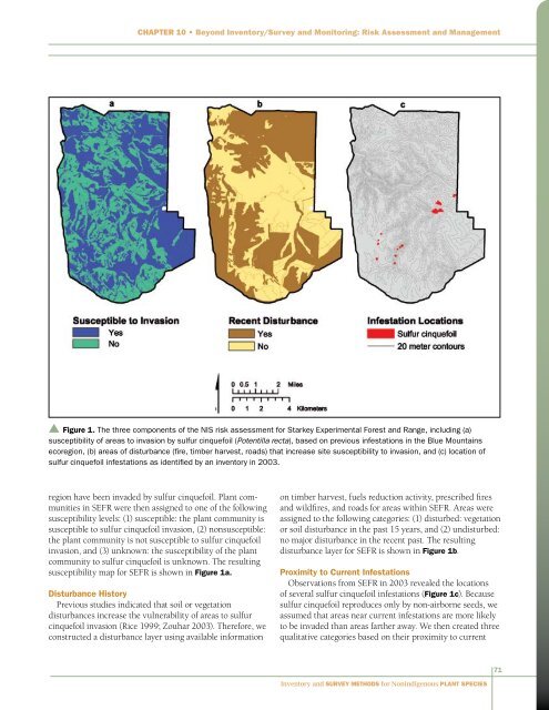
Chapter 10 • Beyond <strong>Inventory</strong>/<strong>Survey</strong> <strong>and</strong> Monitoring: Risk Assessment <strong>and</strong> Management▲ Figure 1. The three components of the NIS risk assessment <strong>for</strong> Starkey Experimental Forest <strong>and</strong> Range, including (a)susceptibility of areas to invasion by sulfur cinquefoil (Potentilla recta), based on previous infestations in the Blue Mountainsecoregion, (b) areas of disturbance (fire, timber harvest, roads) that increase site susceptibility to invasion, <strong>and</strong> (c) location ofsulfur cinquefoil infestations as identified by an inventory in 2003.region have been invaded by sulfur cinquefoil. <strong>Plant</strong> communitiesin SEFR were then assigned to one of the followingsusceptibility levels: (1) susceptible: the plant community issusceptible to sulfur cinquefoil invasion, (2) nonsusceptible:the plant community is not susceptible to sulfur cinquefoilinvasion, <strong>and</strong> (3) unknown: the susceptibility of the plantcommunity to sulfur cinquefoil is unknown. The resultingsusceptibility map <strong>for</strong> SEFR is shown in Figure 1a.Disturbance HistoryPrevious studies indicated that soil or vegetationdisturbances increase the vulnerability of areas to sulfurcinquefoil invasion (Rice 1999; Zouhar 2003). There<strong>for</strong>e, weconstructed a disturbance layer using available in<strong>for</strong>mationon timber harvest, fuels reduction activity, prescribed fires<strong>and</strong> wildfires, <strong>and</strong> roads <strong>for</strong> areas within SEFR. Areas wereassigned to the following categories: (1) disturbed: vegetationor soil disturbance in the past 15 years, <strong>and</strong> (2) undisturbed:no major disturbance in the recent past. The resultingdisturbance layer <strong>for</strong> SEFR is shown in Figure 1b.Proximity to Current InfestationsObservations from SEFR in 2003 revealed the locationsof several sulfur cinquefoil infestations (Figure 1c). Becausesulfur cinquefoil reproduces only by non-airborne seeds, weassumed that areas near current infestations are more likelyto be invaded than areas farther away. We then created threequalitative categories based on their proximity to current71<strong>Inventory</strong> <strong>and</strong> <strong>Survey</strong> <strong>Methods</strong> <strong>for</strong> <strong>Nonindigenous</strong> <strong>Plant</strong> <strong>Species</strong>