The City of Hilliard Sustainability Plan
The City of Hilliard Sustainability Plan
The City of Hilliard Sustainability Plan

You also want an ePaper? Increase the reach of your titles
YUMPU automatically turns print PDFs into web optimized ePapers that Google loves.
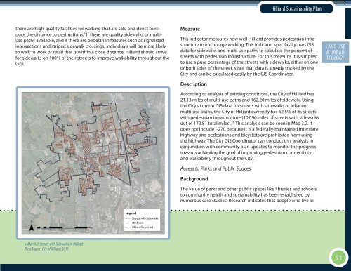
<strong>Hilliard</strong> <strong>Sustainability</strong> <strong>Plan</strong>there are high-quality facilities for walking that are safe and direct to reducethe distance to destinations. 9 If there are quality sidewalks or multiusepaths available, and if there are pedestrian features such as signalizedintersections and striped sidewalk crossings, individuals will be more likelyto walk to work or retail that is within a close distance. <strong>Hilliard</strong> should strivefor sidewalks on 100% <strong>of</strong> their streets to improve walkability throughout the<strong>City</strong>.MeasureThis indicator measures how well <strong>Hilliard</strong> provides pedestrian infrastructureto encourage walking. This indicator specifically uses GISdata for sidewalks and multi-use paths to calculate the percent <strong>of</strong>streets with pedestrian infrastructure. For this measure, it is simplestto use a pure percentage <strong>of</strong> the streets with sidewalks, either on oneor both sides <strong>of</strong> the street, since that data is already tracked by the<strong>City</strong> and can be calculated easily by the GIS Coordinator.DescriptionAccording to analysis <strong>of</strong> existing conditions, the <strong>City</strong> <strong>of</strong> <strong>Hilliard</strong> has21.13 miles <strong>of</strong> multi-use paths and 162.20 miles <strong>of</strong> sidewalk. Usingthe <strong>City</strong>’s current GIS data for streets with sidewalks or adjacentmulti-use paths, the <strong>City</strong> <strong>of</strong> <strong>Hilliard</strong> currently has 62.5% <strong>of</strong> its streetswith pedestrian infrastructure (107.96 miles <strong>of</strong> streets with sidewalksout <strong>of</strong> 172.81 total miles). 10 This analysis can be seen in Map 3.2. Itdoes not include I-270 because it is a federally-maintained Interstatehighway and pedestrians and bicyclists are prohibited from usingthe highway. <strong>The</strong> <strong>City</strong> GIS Coordinator can conduct this analysis inconjunction with community plan updates to monitor the progresstowards achieving the goal <strong>of</strong> improving pedestrian connectivityand walkability throughout the <strong>City</strong>.Access to Parks and Public SpacesBackground<strong>The</strong> value <strong>of</strong> parks and other public spaces like libraries and schoolsto community health and sustainability has been established bynumerous case studies. Research indicates that people who live inECON. EXECUTIVELAND DEV. USESOCIAL SUMMARY& URBAN EQ.ECOLOGY» Map 3.2: Streets with Sidewalks in <strong>Hilliard</strong>Data Source: <strong>City</strong> <strong>of</strong> <strong>Hilliard</strong>, 201151