The City of Hilliard Sustainability Plan
The City of Hilliard Sustainability Plan
The City of Hilliard Sustainability Plan

You also want an ePaper? Increase the reach of your titles
YUMPU automatically turns print PDFs into web optimized ePapers that Google loves.
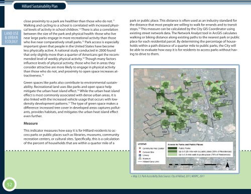
<strong>Hilliard</strong> <strong>Sustainability</strong> <strong>Plan</strong>ECON. EXECUTIVELAND USE DEV.SOCIAL SUMMARY& URBAN EQ.ECOLOGYclose proximity to a park are healthier than those who do not. 11Walking and cycling to a school is correlated with increased physicallevels <strong>of</strong> activity in school children. 12 <strong>The</strong>re is also a correlationbetween the size <strong>of</strong> the park and physical health: those who livenear large parks engage in more recreational activity than thosewho live near comparatively small parks. 13 Park access is especiallyimportant given that people in the United States have becomeless physically active. A national study conducted in 2000 foundthat only slightly more than a quarter <strong>of</strong> Americans get the recommendedlevel <strong>of</strong> weekly physical activity. 14 Though many factorsinfluence levels <strong>of</strong> physical activity, those who live in areas theyconsider attractive are more likely to engage in physical activitythan those who do not, and proximity to open space increases attractiveness.15Green spaces like parks also contribute to environmental sustainability.Recreational land uses like parks and open space helpmitigate the urban heat island effect. 16 While the urban heat islandeffect is most commonly associated with dense urban areas, it isalso linked with the increased vehicle usage that occurs with lowdensitydevelopment patterns. 17 <strong>The</strong> type <strong>of</strong> green space makes adifference: increased tree cover in developed areas captures pollutants,provides habitats, and mitigates the urban heat island effecteven further.MeasureThis indicator measures how easy it is for <strong>Hilliard</strong> residents to accessparks or public places such as libraries, museums, communityrecreation centers, or cultural sites. Specifically, this is a calculation<strong>of</strong> the percent <strong>of</strong> households that are within a quarter mile <strong>of</strong> apark or public place. This distance is <strong>of</strong>ten used as an industry standard forthe distance that most people are willing to walk for errands and to transitstops. 18 This measure can be calculated by the <strong>City</strong> GIS Coordinator usingexisting street network data. <strong>The</strong> Network Analyst tool in ArcGIS calculateswalking or biking distance along existing paths to the nearest park or publicplace for each residential parcel. By determining the percentage <strong>of</strong> householdswithin a path distance <strong>of</strong> a quarter mile to public parks, the <strong>City</strong> willbe able to evaluate how easy it is for residents to access parks without havingto drive to them.52» Map 3.3: Park Accessibility Data Sources: <strong>City</strong> <strong>of</strong> <strong>Hilliard</strong>, 2011; MORPC, 2011