The City of Hilliard Sustainability Plan
The City of Hilliard Sustainability Plan
The City of Hilliard Sustainability Plan

Create successful ePaper yourself
Turn your PDF publications into a flip-book with our unique Google optimized e-Paper software.
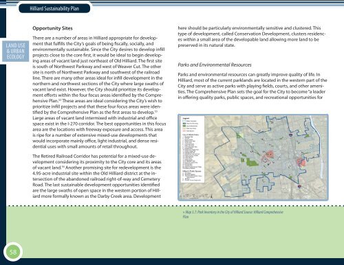
<strong>Hilliard</strong> <strong>Sustainability</strong> <strong>Plan</strong>ECON. EXECUTIVELAND USE DEV.SOCIAL SUMMARY& URBAN EQ.ECOLOGYOpportunity Sites<strong>The</strong>re are a number <strong>of</strong> areas in <strong>Hilliard</strong> appropriate for developmentthat fulfills the <strong>City</strong>’s goals <strong>of</strong> being fiscally, socially, andenvironmentally sustainable. Since the <strong>City</strong> desires to develop infillprojects close to the core first, it would be ideal to begin developingareas <strong>of</strong> vacant land just northeast <strong>of</strong> Old <strong>Hilliard</strong>. <strong>The</strong> first siteis south <strong>of</strong> Northwest Parkway and west <strong>of</strong> Weaver Cut. <strong>The</strong> othersite is north <strong>of</strong> Northwest Parkway and southwest <strong>of</strong> the railroadline. <strong>The</strong>re are many other areas ideal for infill development in thenorthern and northwest sections <strong>of</strong> the <strong>City</strong> where large swaths <strong>of</strong>vacant land exist. However, the <strong>City</strong> should prioritize its developmentefforts within the four focus areas identified by the Comprehensive<strong>Plan</strong>. 52 <strong>The</strong>se areas are ideal considering the <strong>City</strong>’s wish toprioritize infill projects and that these four focus areas were identifiedby the Comprehensive <strong>Plan</strong> as the first areas to develop. 53Large areas <strong>of</strong> vacant land intermixed with industrial and <strong>of</strong>ficespace exist in the I-270 corridor. <strong>The</strong> best opportunities in this focusarea are the locations with freeway exposure and access. This areais ripe for a number <strong>of</strong> extensive mixed-use developments thatwould incorporate mainly <strong>of</strong>fice, light industrial, and dense residentialuses with small amounts <strong>of</strong> retail throughout.<strong>The</strong> Retired Railroad Corridor has potential for a mixed-use developmentconsidering its proximity to the <strong>City</strong> core and its areas<strong>of</strong> vacant land. 54 Another promising site for redevelopment is the4.95-acre industrial site within the Old <strong>Hilliard</strong> district at the intersection<strong>of</strong> the abandoned railroad right-<strong>of</strong>-way and CemeteryRoad. <strong>The</strong> last sustainable development opportunities identifiedare the large swaths <strong>of</strong> open space in the western portion <strong>of</strong> <strong>Hilliard</strong>more formally known as the Darby Creek area. Developmenthere should be particularly environmentally sensitive and clustered. Thistype <strong>of</strong> development, called Conservation Development, clusters residenceswithin a small area <strong>of</strong> the developable land allowing more land to bepreserved in its natural state.Parks and Environmental ResourcesParks and environmental resources can greatly improve quality <strong>of</strong> life. In<strong>Hilliard</strong>, most <strong>of</strong> the current parklands are located in the western part <strong>of</strong> the<strong>City</strong> and serve as active parks with playing fields, courts, and other amenities.<strong>The</strong> Comprehensive <strong>Plan</strong> sets the goal for the <strong>City</strong> to become “a leaderin <strong>of</strong>fering quality parks, public spaces, and recreational opportunities for» Map 3.7: Park Inventory in the <strong>City</strong> <strong>of</strong> <strong>Hilliard</strong> Source: <strong>Hilliard</strong> Comprehensive<strong>Plan</strong>58