

Download PDF - COINAtlantic
Download PDF - COINAtlantic
Download PDF - COINAtlantic
- No tags were found...

Create successful ePaper yourself
Turn your PDF publications into a flip-book with our unique Google optimized e-Paper software.
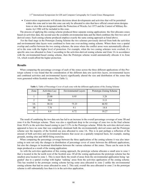
11 th International Symposium for GIS and Computer Cartography for Coastal Zones Management Conservation requirements will dictate decisions about developments and activities that will be permittedwithin this zone and in turn this zone can only be allocated to sites that have official conservation designationsor sites that are designated under the Protection of Wrecks Act 1973 and the Control of Military RemainsAct 1986 will be included in this zone.The process of applying this zoning scheme produced three separate zoning applications: the first allocates zonesbased on activities data, the second uses the available environmental data and the third combines the first two sets ofderived zones. Each zoning scheme produced employs exactly the same zoning approach as listed above.For the final stage in the Prototype Zoning Scheme the two schemes previously derived from both the activitiesand environmental data layers were combined to form one over-arching zoning scheme. Where there was a spatialoverlap and conflict between the two zoning schemes, the areas where the conflict arose were automatically allocatedto the zone with the higher level of protection. For example, when the two zoning schemes were overlaid, if aspecific area was allocated to Zone 2 according to the activities-derived zoning scheme and Zone 3A in accordancewith the environmental-based zoning scheme, then the Prototype scheme would automatically allocate it to Zone3A, which would afford the higher protection.ResultsWhen comparing the percentage coverage of each of the zones across the three different applications of this Prototypescheme it was found that the consideration of the different data sets (activities layers, environmental layersand combined activities and environmental layers) significantly altered the size and distribution of the zones thatwere generated within Scottish waters (See Table 1).Table 1. Table of Percentage Cover of each zone with the different applications of the Zoning SchemeZone Activities LayersEnvironmental Layers Prototype Zoning Scheme1 25.08 8.95 3.282 30.6 5.133A 30.16 75.23 66.923B 7.76 9.1 14.44 6.4 6.72 10.27The result of combining the two data sets has led to an increase in the overall percentage coverage of zone 3B andzone 4 in the Prototype scheme. There was also a significant drop in the coverage of zone two in the final schemefrom 30.6% in the activities based zoning to just 5.13% in the Prototype scheme. While the activities derived zonesappeared to have no zone that was completely dominant both the environmentally derived zones and the Prototypescheme saw the majority of the Scottish sea area allocated to zone 3A. This is in part perhaps a reflection of theamount of both activities and environmental features that occur on a spatially temporal basis, for example, matinggrounds, nesting sites and MOD firing exercises.When comparing the percentage coverage between the three applications of the zoning scheme it was also interestingto note not only the changes in distribution of percentage cover of zones between the different applications,but also the changes in locational distribution between the various schemes of the zones. These can be seen in themaps produced as a result of the zoning application.As with the activities application of this zoning approach, the prototype scheme allocates a small area to zone 1that is located in the far north west of the Scottish seas. Of all the zoning applications the prototype scheme has thesmallest area located to zone 1. This is most likely the result of areas from the environmental application being ‘upgraded’due to a spatial overlap with higher ‘ranking’ areas from the activities application of the zoning scheme.This has resulted in the prototype zoning scheme having some area allocated to zone 2 unlike the environmentalzoning scheme that had no areas allocated to zone 2. This said, overall the area allocated to zone 2 in the prototypescheme is still substantially less than it is in the activities application.90


