

Download PDF - COINAtlantic
Download PDF - COINAtlantic
Download PDF - COINAtlantic
- No tags were found...

Create successful ePaper yourself
Turn your PDF publications into a flip-book with our unique Google optimized e-Paper software.
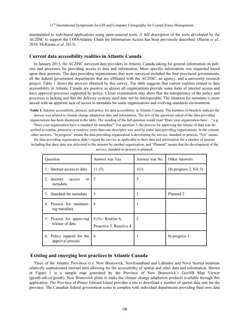
11 th International Symposium for GIS and Computer Cartography for Coastal Zones Managementmanipulated in web-based applications using open-sourced tools. A full description of the tools developed by theACZISC to support the <strong>COINAtlantic</strong> Chain for Information Access has been previously described. (Sherin et al.,2010, McKenna et al. 2013).Current data accessibility realities in Atlantic CanadaIn January 2013, the ACZISC surveyed data providers in Atlantic Canada asking for general information on policiesand processes for providing access to data and information. More specific information was requested basedupon their answers. The data providing organizations that were surveyed included the four provincial governments,all the federal government departments that are affiliated with the ACZISC, an agency, and a university researchproject. Table 1 shows the answers obtained by this survey. The table suggests that current realities related to dataaccessibility in Atlantic Canada are positive as almost all organizations provide some form of internet access andhave approval processes supported by policy. Closer examination may show that the transparency of the policy andprocesses is lacking and that the delivery systems used may not be interoperable. The situation for metadata is moremixed with an apparent lack of access to metadata for some organizations and evolving standards environment.Table 1. Internet accessibility, process, and policy for data accessibility in Atlantic Canada. The numbers in brackets indicate theanswer was related to climate change adaptation data and information. The text of the questions asked of the data providingorganizations has been shortened in the table. The wording of the full question would read “Does your organization have…” e.g.“Does your organization have a standard for metadata?” For question 5, the process for approving the release of data was describedas routine, proactive or reactive; more than one descriptor was used by some data providing organizations. In the columnother answers, “In progress” means the data providing organization is developing the service, standard or process, “NA” meansthe data providing organization didn’t regard the service as applicable to their data and information for a number of reasonsincluding that their data was delivered to the internet by another organization, and “Planned” means that the development of theservice, standard or process is planned.Question Answer was Yes Answer was No Other Answers1. Internet access to data 11 (5) 1(1) (In progress 2, NA 3)2. Internet access tometadata5 53. Standard for metadata 3 1 Planned 24. Process for maintainingmetadata4 15. Process for approvingrelease of data8 (5) - Routine 6,Proactive 5, Reactive 426. Policy support for theapproval process6 1 In progress 1Existing and emerging best practices in Atlantic CanadaThree of the Atlantic Provinces (i.e. New Brunswick, Newfoundland and Labrador and Nova Scotia) maintainrelatively sophisticated internet sites allowing for the accessibility of spatial and other data and information. Shownin Figure 1 is a sample map generated by the Province of New Brunswick’s GeoNB Map Viewer(geonb.snb.ca/geonb). New Brunswick plans to make the climate change adaptation products available through thisapplication. The Province of Prince Edward Island provides a site to download a number of spatial data sets for theprovince. The Canadian federal government scene is complex with individual departments providing their own data136


