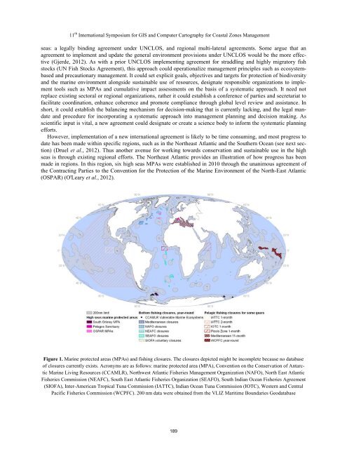
Methods11 th International Symposium for GIS and Computer Cartography for Coastal Zones ManagementWe collated data on spatial management in the high seas, which had not previously been compiled. Data includedmanagement measures such as regional fisheries management organizations (RFMOs), regional seas organizations,marine protected areas, and fisheries closures with some permanence. Furthermore, we reviewed existing policy andspatial management measures in the high seas, and assessed whether these encompass the suggested stages of systematicconservation planning (Margules and Pressey, 2000; Pressey and Bottrill, 2009). We then used this analysisof spatial and policy gaps to recommend a course for the future.ResultsSixty-four percent of the surface of the world’s oceans fall in the high seas (or 95% of the volume), yet currentgovernance of the high seas is spatially incomplete and fragmented. Activities in some regions having no agreementsin place (e.g., the regulation of fisheries in the southwest Atlantic) and other areas with fisheries agreementsyet to come into force (e.g., the north Pacific) (Gjerde, 2012). Further gaps are evident in the adoption and applicationof spatial management measures (Figure 1). Moreover, of the 18 regional seas organizations charged with ensuringcooperation for conservation and sustainable development, only four include areas of the high seas (Gjerdeand Rulska-Domino, 2012). The regions of the world that are approaching comprehensive management are theSouthern Ocean under CCAMLR (about 10% of the world’s oceans, and 15% of the high seas), and marine protectedareas in the NE Atlantic that also have complementary fisheries management (about 0.08% of the world’s oceans,and 0.12% of the high seas). This means that about 85% of the high seas are lacking comprehensive and integratedmanagement.The result of the traditional approach taken to manage the high seas has been a limited, regional, sector-by-sectorapproach, with multiple authorities managing parts of the same regions, extensive areas without governance arrangements,and few attempts to coordinate activities, mitigate conflicts, address cumulative impacts, or facilitatecommunication. Such regional agreements only apply to participating states and are exposed to the risk that thirdparties will not join or abide by the rules (Gjerde et al., 2008), contributing to major deficiencies identified in mostregional fisheries management organizations (Cullis-Suzuki and Pauly, 2010). The only global agreement that containsclear objectives for conservation and sustainable use of marine biodiversity, the Convention on BiologicalDiversity (CBD), currently has limited legal authority in the high seas, and serves mainly as a vehicle to promotecooperation and provide scientific and technical advice, including describing ecologically or biologically significantareas (Dunn et al., 2011). Of the organizations or conventions with authority over some portion of the high seas,perhaps only the Southern Ocean is approaching “comprehensive management” (i.e., ecosystem-based, integrated,systematic, with spatial and non-spatial measures and coordinated science to inform management), and even thenonly for use of living marine resources. No other high seas management authority has conservation as a major objective.Yet the science and expectations of the international community, as made clear at Rio +20, has changed in the40 years since UNCLOS was first negotiated, such that ecosystem-based management and conservation, includingprotected areas, are expected to be a core concern.DiscussionThe general lack of a systematic approach is a serious concern for effective management of the high seas. Systematicconservation planning can significantly contribute to achieving successful conservation and sustainable useof biodiversity and resources in the high seas. Without systematic planning, there is little scope for integrating acrosssectors, working towards agreed objectives, or designing and implementing comprehensive and cost-effective managementactions. However, systematic conservation planning is not the sole ingredient needed to achieve thesegoals. We have identified five key elements for effective use of systematic conservation planning for high seas management,and suggest that these should be integrated into such an approach: ecosystem-based management, integratedmanagement, systematic approach to management and planning, coordinated spatial and non-spatial measures,and coordinated science and monitoring to inform management.Given that no existing management regime comprehensively encompasses systematic conservation planning onthe high seas, nor do they have a mandate to engage in the full planning process, other avenues must be developed.Two complementary approaches are emerging as ways to implement conservation and sustainable use of the high188
11 th International Symposium for GIS and Computer Cartography for Coastal Zones Managementseas: a legally binding agreement under UNCLOS, and regional multi-lateral agreements. Some argue that anagreement to implement and update the general environment provisions under UNCLOS would be the more effective(Gjerde, 2012). As with a prior UNCLOS implementing agreement for straddling and highly migratory fishstocks (UN Fish Stocks Agreement), this approach could operationalize management principles such as ecosystembasedand precautionary management. It could set explicit goals, objectives and targets for protection of biodiversityand the marine environment alongside sustainable use of resources, designate responsible organizations to implementtools such as MPAs and cumulative impact assessments on the basis of a systematic approach. It need notreplace existing sectoral or regional organizations, rather it could establish a conference of parties and secretariat tofacilitate coordination, enhance coherence and promote compliance through global level review and assistance. Inshort, it could establish the balancing mechanism for decision-making that is currently lacking, and the legal mandateand procedure for incorporating a systematic approach into management planning and decision making. Asscientific input is vital, a new agreement could designate or create a science body to inform the systematic planningefforts.However, implementation of a new international agreement is likely to be time consuming, and most progress todate has been made within specific regions, such as in the Northeast Atlantic and the Southern Ocean (see next section)(Druel et al., 2012). Thus another avenue for working towards conservation and sustainable use in the highseas is through existing regional efforts. The Northeast Atlantic provides an illustration of how progress has beenmade in regions. In this region, six high seas MPAs were established in 2010 through the unanimous agreement ofthe Contracting Parties to the Convention for the Protection of the Marine Environment of the North-East Atlantic(OSPAR) (O'Leary et al., 2012).Figure 1. Marine protected areas (MPAs) and fishing closures. The closures depicted might be incomplete because no databaseof closures currently exists. Acronyms are as follows: marine protected area (MPA), Convention on the Conservation of AntarcticMarine Living Resources (CCAMLR), Northwest Atlantic Fisheries Management Organization (NAFO), North East AtlanticFisheries Commission (NEAFC), South East Atlantic Fisheries Organization (SEAFO), South Indian Ocean Fisheries Agreement(SIOFA), Inter-American Tropical Tuna Commission (IATTC), Indian Ocean Tuna Commission (IOTC), Western and CentralPacific Fisheries Commission (WCPFC). 200 nm data were obtained from the VLIZ Maritime Boundaries Geodatabase189