

Download PDF - COINAtlantic
Download PDF - COINAtlantic
Download PDF - COINAtlantic
- No tags were found...

You also want an ePaper? Increase the reach of your titles
YUMPU automatically turns print PDFs into web optimized ePapers that Google loves.
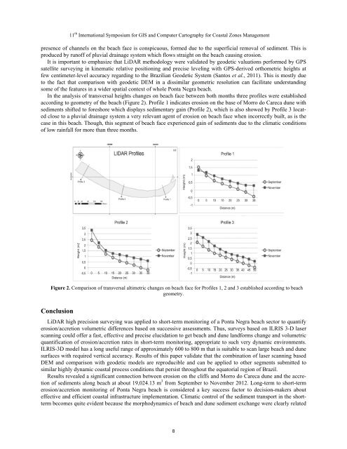
11 th International Symposium for GIS and Computer Cartography for Coastal Zones Managementpresence of channels on the beach face is conspicuous, formed due to the superficial removal of sediment. This isproduced by runoff of pluvial drainage system which flows straight on the beach causing erosion.It is important to emphasize that LiDAR methodology were validated by geodetic valuations performed by GPSsatellite surveying in kinematic relative positioning and precise leveling with GPS-derived orthometric heights atfew centimeter-level accuracy regarding to the Brazilian Geodetic System (Santos et al., 2011). This is mostly dueto the fact that comparison with geodetic DEM in a dissimilar geometric resolution can facilitate understandingsome of the features in a wider spatial context of whole Ponta Negra beach.In the analysis of transversal heights changes on beach face between both months three profiles were establishedaccording to geometry of the beach (Figure 2). Profile 1 indicates erosion on the base of Morro do Careca dune withsediments shifted to foreshore which displays sedimentary gain (Profile 2), which is also showed by Profile 3 locatedclose to a pluvial drainage system a very relevant agent of erosion on beach face when incorrectly built, as is thecase in this beach. Though, this segment of beach face experienced gain of sediments due to the climatic conditionsof low rainfall for more than three months.Figure 2. Comparison of transversal altimetric changes on beach face for Profiles 1, 2 and 3 established according to beachgeometry.ConclusionLiDAR high precision surveying was applied to short-term monitoring of a Ponta Negra beach sector to quantifyerosion/accretion volumetric differences based on successive assessments. Thus, surveys based on ILRIS 3-D laserscanning could offer a fast, effective and precise elucidation to get beach and dune landforms change and volumetricquantification of erosion/accretion rates in short-term monitoring, appropriate to such very dynamic environments.ILRIS-3D model has a long useful range of approximately 600 to 800 m that is suitable to scan large beach and dunesurfaces with required vertical accuracy. Results of this paper validate that the combination of laser scanning basedDEM and comparison with geodetic models are reproducible and can be applied to other segments submitted tosimilar highly dynamic coastal process conditions that persist throughout the equatorial region of Brazil.Results revealed a significant connection between erosion on the cliffs and Morro do Careca dune and the accretionof sediments along beach at about 19,024.13 m 3 from September to November 2012. Long-term to short-termerosion/accretion monitoring of Ponta Negra beach is considered a key success factor to decision-makers abouteffective and efficient coastal infrastructure implementation. Climatic control of the sediment transport in the shorttermbecomes quite evident because the morphodynamics of beach and dune sediment exchange were clearly related8


