

Principles of terrestrial ecosystem ecology.pdf
Principles of terrestrial ecosystem ecology.pdf
Principles of terrestrial ecosystem ecology.pdf

Create successful ePaper yourself
Turn your PDF publications into a flip-book with our unique Google optimized e-Paper software.
phere, extends to depths <strong>of</strong> 75 to 200 m, depending<br />
on the depth <strong>of</strong> wind-driven mixing. Most<br />
primary production, detrital production, and<br />
decomposition take place in the surface waters<br />
(see Chapter 10). Another major difference<br />
between atmospheric and oceanic circulation is<br />
that density <strong>of</strong> ocean waters is determined by<br />
both temperature and salinity, so, unlike warm<br />
air, warm water can sink, if it is salty enough.<br />
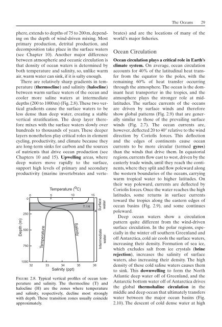
There are relatively sharp gradients in temperature<br />
(thermocline) and salinity (halocline)<br />
between warm surface waters <strong>of</strong> the ocean and<br />
cooler more saline waters at intermediate<br />
depths (200 to 1000m) (Fig. 2.8).These two vertical<br />
gradients cause the surface waters to be<br />
less dense than deep water, creating a stable<br />
vertical stratification. The deep layer therefore<br />
mixes with the surface waters slowly over<br />
hundreds to thousands <strong>of</strong> years. These deeper<br />
layers nonetheless play critical roles in element<br />
cycling, productivity, and climate because they<br />
are long-term sinks for carbon and the sources<br />
<strong>of</strong> nutrients that drive ocean production (see<br />
Chapters 10 and 15). Upwelling areas, where<br />
deep waters move rapidly to the surface,<br />
support high levels <strong>of</strong> primary and secondary<br />
productivity (marine invertebrates and verte-<br />
Depth (m)<br />
0<br />
0<br />
250<br />
500<br />
750<br />
Temperature<br />
Temperature ( o C)<br />
5 10 15<br />
1000<br />
32 33 34 35 36<br />
Salinity (ppt)<br />
Salinity<br />
T / H<br />
Surface<br />
water<br />
Intermediate<br />
water<br />
Figure 2.8. Typical vertical pr<strong>of</strong>iles <strong>of</strong> ocean temperature<br />
and salinity. The thermocline (T) and<br />
halocline (H) are the zones where temperature<br />
and salinity, respectively, decline most strongly<br />
with depth. These transition zones usually coincide<br />
approximately.<br />
The Oceans 29<br />
brates) and are the locations <strong>of</strong> many <strong>of</strong> the<br />
world’s major fisheries.<br />
Ocean Circulation<br />
Ocean circulation plays a critical role in Earth’s<br />
climate system. On average, ocean circulation<br />
accounts for 40% <strong>of</strong> the latitudinal heat transfer<br />
from the equator to the poles, with the<br />
remaining 60% <strong>of</strong> heat transfer occurring<br />
through the atmosphere. The ocean is the dominant<br />
heat transporter in the tropics, and the<br />
atmosphere plays the stronger role at midlatitudes.<br />
The surface currents <strong>of</strong> the oceans<br />
are driven by surface winds and therefore<br />
show global patterns (Fig. 2.9) that are generally<br />
similar to those <strong>of</strong> the prevailing surface<br />
winds (Fig. 2.7). The ocean currents are,<br />
however, deflected 20 to 40° relative to the wind<br />
direction by Coriolis forces. This deflection<br />
and the edges <strong>of</strong> continents cause ocean<br />
currents to be more circular (termed gyres)<br />
than the winds that drive them. In equatorial<br />
regions, currents flow east to west, driven by the<br />
easterly trade winds, until they reach the continents,<br />
where they split and flow poleward along<br />
the western boundaries <strong>of</strong> the oceans, carrying<br />
warm tropical water to higher latitudes. On<br />
their way poleward, currents are deflected by<br />
Coriolis forces. Once the water reaches the high<br />
latitudes, some returns in surface currents<br />
toward the tropics along the eastern edges <strong>of</strong><br />
ocean basins (Fig. 2.9), and some continues<br />
poleward.<br />
Deep ocean waters show a circulation<br />
pattern quite different from the wind-driven<br />
surface circulation. In the polar regions, especially<br />
in the winter <strong>of</strong>f southern Greenland and<br />
<strong>of</strong>f Antarctica, cold air cools the surface waters,<br />
increasing their density. Formation <strong>of</strong> sea ice,<br />
which excludes salt from ice crystals (brine<br />
rejection), increases the salinity <strong>of</strong> surface<br />
waters, also increasing their density. The high<br />
density <strong>of</strong> these cold saline waters causes them<br />
to sink. This downwelling to form the North<br />
Atlantic deep water <strong>of</strong>f <strong>of</strong> Greenland, and the<br />
Antarctic bottom water <strong>of</strong>f <strong>of</strong> Antarctica drives<br />
the global thermohaline circulation in the<br />
middle and deep ocean that ultimately transfers<br />
water between the major ocean basins (Fig.<br />
2.10). The descent <strong>of</strong> cold dense water at high