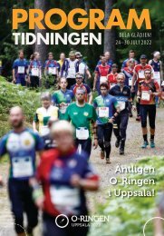
Programme O-Ringen Värmland 2017

Create successful ePaper yourself
Turn your PDF publications into a flip-book with our unique Google optimized e-Paper software.
L START<br />
PROGRAMME O-RINGEN VÄRMLAND <strong>2017</strong><br />
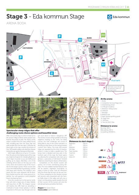
23<br />
Stage 3 - Eda kommun Stage<br />
ARENA BODA<br />
BUSES<br />
CAR PARKING<br />
Club tents<br />
Sit<br />
Sit<br />
Sit<br />
1.<br />
3. 4.<br />
2.<br />
TO<br />
SHOWERS<br />
Club tents<br />
Sit<br />
Sit<br />
1.<br />
9.<br />
10.<br />
1.<br />
7.<br />
8.<br />
1.<br />
Sit<br />
6.<br />
Sit<br />
11.<br />
Club tents<br />
COMPETITION AREA<br />
Stand<br />
12.<br />
5.<br />
COMPETITION AREA<br />
TO START<br />
STAGE 3<br />
Remember to pass through<br />
the verification station on<br />
your way to start<br />
Spectacular steep ridges that offer<br />
challenging route choice options and beautiful views<br />
After a fun activity day, it is time to head out to<br />
the ancient village of Boda, where people have<br />
lived for thousands of years. This history of this<br />
region is evident from the many artifacts found<br />
here, including axes from the Stone Age and<br />
gold amulets from the Iron Age. A 200-year-old<br />
grave right on the map contains the remains of<br />
over 100 Swedish soldiers who died from disease<br />
during the war against Norway and Denmark.<br />
With height differences of up to 175 meters<br />
from the arena to the highest parts of the map,<br />
you might be forgiven for mistaking Boda for a<br />
much larger mountain as you are huffing and<br />
puffing up its slopes. Mercifully, a lot of the<br />
climbing will be done on the way up to the<br />
starts, which are located on top of the mountain<br />
for the longer courses. These courses start<br />
out on the relatively flat mountaintop, covered<br />
with large, open marshes. The visibility is very<br />
good, and your main obstacles will be blueberry<br />
bushes and the soft, mossy ground underfoot.<br />
You will experience some delightful<br />
forest orienteering here!<br />
Once the courses turn to the west or north,<br />
they will enter a large area of steep hillsides<br />
and long lines of cliffs. The longest courses<br />
will traverse the cliffs head on, providing a<br />
multitude of route choice options. It will be<br />
important to find your way through and not<br />
get stuck above or below a dangerous cliff.<br />
The shorter courses will go parallel to the long<br />
ridgelines heading to the north. For these<br />
courses, the main challenges will consist of<br />
being able to stay on the correct elevation, or<br />
deciding to drop down to the road and attack<br />
controls from below. The long cliff-covered<br />
ridges are separated by thin lines of marshes,<br />
where it is easy to make a parallel error. The<br />
terrain here is detailed and truly wild. In the<br />
northern part of the map, the forest opens<br />
up, allowing the competitors who look up to<br />
glimpse a panorama of <strong>Värmland</strong>’s forested<br />
wilderness stretching for dozens of kilometers.<br />
Competitors on the shorter courses will<br />
spend a lot of time orienteering along hillsides.<br />
The most reliable handrail features here<br />
will be streams, vegetation boundaries, or<br />
edges of clear-cut areas. Trails are infrequent<br />
here, but those that do exist can be very useful.<br />
Those competing on the shortest courses<br />
will become well acquainted with the farmers’<br />
fields down in the valley and will cross a<br />
stream running along a gully towards the end<br />
of their courses. All the courses will cross the<br />
old railroad tracks just before the finish.<br />
Mapper: Nils-Göran Olsson<br />
Course setter: Joakim Mellkvist<br />
Distances to start stage 3<br />
Bagheera<br />
CCS<br />
Moelven<br />
SIA Glass<br />
Team Sportia<br />
Tork/SCA<br />
Cramo<br />
Volvo CE<br />
1950 m<br />
1550 m<br />
1950 m<br />
1950 m<br />
1750 m<br />
1430 m<br />
1300 m<br />
500 m<br />
At the arena<br />
1. Kiosks<br />
2. Competitor Services/Stage start<br />
3. Orienteering school<br />
4. O-<strong>Ringen</strong> Academy<br />
5. Miniknat / String course<br />
6. Childcare<br />
7. Massage<br />
8. Medical care<br />
9. Team Sportia sporting goods<br />
10. Stage host<br />
11. VIP/Press<br />
12. Tent for DH21 Elite<br />
Distance to arena<br />
Bus stop: 300 m<br />
Bike parking: 300 m<br />
Car parking: 200-800 m