

Crown Land: Indicators and Statistics - Ministry of Forests
Crown Land: Indicators and Statistics - Ministry of Forests
Crown Land: Indicators and Statistics - Ministry of Forests

Create successful ePaper yourself
Turn your PDF publications into a flip-book with our unique Google optimized e-Paper software.
<strong>Crown</strong> <strong>L<strong>and</strong></strong>:<br />
<strong>Indicators</strong> <strong>and</strong><br />
96 <strong>Statistics</strong> Report<br />
Box 4 Roads <strong>and</strong> Corridors on <strong>Crown</strong> <strong>L<strong>and</strong></strong><br />
The length <strong>and</strong> density <strong>of</strong> roads <strong>and</strong> corridors provide measures <strong>of</strong> the degree to which <strong>Crown</strong> l<strong>and</strong><br />
has been affected by human activity, since roads are constructed to provide access for urban <strong>and</strong><br />
industrial development.<br />
There are a total <strong>of</strong> 821,848 kilometres <strong>of</strong> roads <strong>and</strong> corridors (including railways, transmission lines,<br />
pipelines <strong>and</strong> seismic lines) throughout BC, on both <strong>Crown</strong> <strong>and</strong> private l<strong>and</strong>. Table 15 shows the length<br />
<strong>and</strong> density <strong>of</strong> roads <strong>and</strong> corridors, <strong>and</strong> seismic lines, in each sub-region.<br />
Increasing road <strong>and</strong> corridor<br />
length <strong>and</strong> density may have the<br />
following social, economic <strong>and</strong><br />
environmental outcomes:<br />
• Providing access to<br />
resources;<br />
• Providing access to rural<br />
communities;<br />
• Fragmenting <strong>and</strong> altering<br />
wildlife habitat;<br />
• Isolating wildlife<br />
populations;<br />
• Changing water quality in<br />
nearby water bodies; <strong>and</strong>/or<br />
• Increasing the widespread<br />
distribution <strong>of</strong> exotic species.<br />
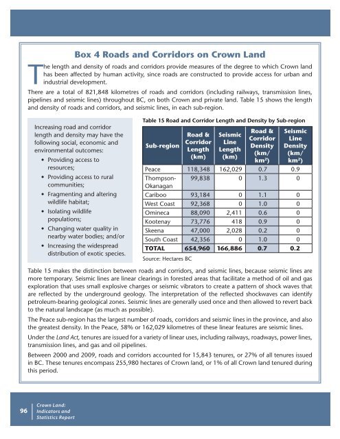
Table 15 Road <strong>and</strong> Corridor Length <strong>and</strong> Density by Sub-region<br />
Sub-region<br />
Road &<br />
Corridor<br />
Length<br />
(km)<br />
Seismic<br />
Line<br />
Length<br />
(km)<br />
Road &<br />
Corridor<br />
Density<br />
(km/<br />
km 2 )<br />
Seismic<br />
Line<br />
Density<br />
(km/<br />
km 2 )<br />
Peace 118,348 162,029 0.7 0.9<br />
Thompson-<br />
Okanagan<br />
99,838 0 1.3 0<br />
Cariboo 93,184 0 1.1 0<br />
West Coast 92,368 0 1.0 0<br />
Omineca 88,090 2,411 0.6 0<br />
Kootenay 73,776 418 0.9 0<br />
Skeena 47,000 2,028 0.2 0<br />
South Coast 42,356 0 1.0 0<br />
TOTAL 654,960 166,886 0.7 0.2<br />
Source: Hectares BC<br />
Table 15 makes the distinction between roads <strong>and</strong> corridors, <strong>and</strong> seismic lines, because seismic lines are<br />
more temporary. Seismic lines are linear clearings in forested areas that facilitate a method <strong>of</strong> oil <strong>and</strong> gas<br />
exploration that uses small explosive charges or seismic vibrators to create a pattern <strong>of</strong> shock waves that<br />
are reflected by the underground geology. The interpretation <strong>of</strong> the reflected shockwaves can identify<br />
petroleum-bearing geological zones. Seismic lines are generally used once <strong>and</strong> then allowed to revert back<br />
to the natural l<strong>and</strong>scape (as much as possible).<br />
The Peace sub-region has the largest number <strong>of</strong> roads, corridors <strong>and</strong> seismic lines in the province, <strong>and</strong> also<br />
the greatest density. In the Peace, 58% or 162,029 kilometres <strong>of</strong> these linear features are seismic lines.<br />
Under the <strong>L<strong>and</strong></strong> Act, tenures are issued for a variety <strong>of</strong> linear uses, including railways, roadways, power lines,<br />
transmission lines, <strong>and</strong> gas <strong>and</strong> oil pipelines.<br />
Between 2000 <strong>and</strong> 2009, roads <strong>and</strong> corridors accounted for 15,843 tenures, or 27% <strong>of</strong> all tenures issued<br />
in BC. These tenures encompass 255,980 hectares <strong>of</strong> <strong>Crown</strong> l<strong>and</strong>, or 1% <strong>of</strong> all <strong>Crown</strong> l<strong>and</strong> tenured during<br />
this period.


