Cap.5 - Le carte di navigazione
Cap.5 - Le carte di navigazione
Cap.5 - Le carte di navigazione

Create successful ePaper yourself
Turn your PDF publications into a flip-book with our unique Google optimized e-Paper software.
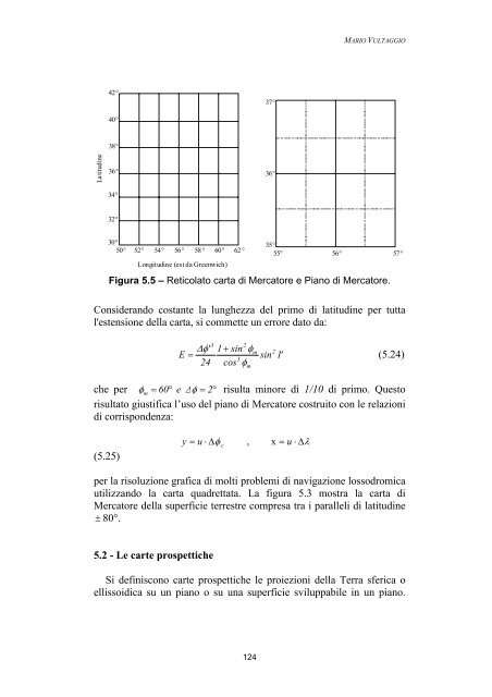
Latitu<strong>di</strong>ne<br />
42°<br />
40°<br />
38°<br />
36°<br />
34°<br />
32°<br />
30°<br />
50° 52° 54° 56°<br />
58 ° 60° 62 °<br />
Longitu<strong>di</strong>ne (est da Greenwich)<br />
124<br />
37°<br />
36°<br />
35°<br />
55°<br />
MARIO VULTAGGIO<br />
56° 57°<br />
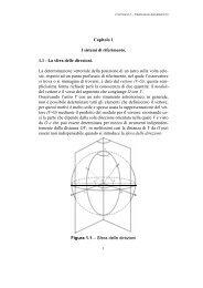
Figura 5.5 – Reticolato carta <strong>di</strong> Mercatore e Piano <strong>di</strong> Mercatore.<br />
Considerando costante la lunghezza del primo <strong>di</strong> latitu<strong>di</strong>ne per tutta<br />
l'estensione della carta, si commette un errore dato da:<br />
3<br />
2<br />
Δ φ'<br />
1 + sin φm<br />
2<br />
E = sin 1'<br />
(5.24)<br />
3<br />
24 cos φ<br />
m<br />
che per φ m = 60°<br />
e Δφ<br />
= 2°<br />
risulta minore <strong>di</strong> 1/10 <strong>di</strong> primo. Questo<br />
risultato giustifica l’uso del piano <strong>di</strong> Mercatore costruito con le relazioni<br />
<strong>di</strong> corrispondenza:<br />
(5.25)<br />
y c x<br />
= u ⋅ Δφ<br />
, = u ⋅ Δλ<br />
per la risoluzione grafica <strong>di</strong> molti problemi <strong>di</strong> <strong>navigazione</strong> lossodromica<br />
utilizzando la carta quadrettata. La figura 5.3 mostra la carta <strong>di</strong><br />
Mercatore della superficie terrestre compresa tra i paralleli <strong>di</strong> latitu<strong>di</strong>ne<br />
± 80°.<br />
5.2 - <strong>Le</strong> <strong>carte</strong> prospettiche<br />
Si definiscono <strong>carte</strong> prospettiche le proiezioni della Terra sferica o<br />
ellissoi<strong>di</strong>ca su un piano o su una superficie sviluppabile in un piano.