- Page 1:
PERSONNEL QUALIFICATION STANDARD (P
- Page 4 and 5:
TABLE OF CONTENTS Page History & Si
- Page 6 and 7:
This page was intentionally left bl
- Page 8 and 9:
101 Marine Corps History, Customs a
- Page 10 and 11:
101 Marine Corps History, Customs a
- Page 12 and 13:
101 Marine Corps History, Customs a
- Page 14 and 15:
101 Marine Corps History, Customs a
- Page 16 and 17:
101 Marine Corps History, Customs a
- Page 18 and 19:
102 USMC Mission and Organization 1
- Page 20 and 21:
102 USMC Mission and Organization M
- Page 22 and 23:
102 USMC Mission and Organization 1
- Page 24 and 25:
102 USMC Mission and Organization o
- Page 26 and 27:
102 USMC Mission and Organization o
- Page 28 and 29:
102 USMC Mission and Organization T
- Page 30 and 31:
102 USMC Mission and Organization T
- Page 32 and 33:
102 USMC Mission and Organization A
- Page 34 and 35:
102 USMC Mission and Organization R
- Page 36 and 37:
102 USMC Mission and Organization U
- Page 38 and 39:
102 USMC Mission and Organization W
- Page 40 and 41:
103 Safety Fundamentals Operational
- Page 42 and 43:
103 Safety Fundamentals TRAINING In
- Page 44 and 45:
103 Safety Fundamentals RESPIRATORY
- Page 46 and 47:
103 Safety Fundamentals Identifying
- Page 48 and 49:
104 Administrative Fundamentals are
- Page 50 and 51:
104 Administrative Fundamentals 104
- Page 52 and 53:
104 Administrative Fundamentals adj
- Page 54 and 55:
104 Administrative Fundamentals col
- Page 56 and 57:
104 Administrative Fundamentals As
- Page 58 and 59:
104 Administrative Fundamentals ass
- Page 60 and 61:
104 Administrative Fundamentals Spe
- Page 62 and 63:
104 Administrative Fundamentals sig
- Page 64 and 65:
104 Administrative Fundamentals Spe
- Page 66 and 67:
104 Administrative Fundamentals Thi
- Page 68 and 69:
105 Air Combat Element (ACE) each f
- Page 70 and 71:
105 Air Combat Element (ACE) Tactic
- Page 72 and 73:
105 Air Combat Element (ACE) (airbo
- Page 74 and 75:
105 Air Combat Element (ACE) 105-8
- Page 76 and 77:
105 Air Combat Element (ACE) the MA
- Page 78 and 79:
105 Air Combat Element (ACE) 105.7
- Page 80 and 81:
105 Air Combat Element (ACE) 105-14
- Page 82 and 83:
105 Air Combat Element (ACE) c. CH-
- Page 84 and 85:
105 Air Combat Element (ACE) i. KC-
- Page 86 and 87:
105 Air Combat Element (ACE) pole c
- Page 88 and 89:
105 Air Combat Element (ACE) Assis
- Page 90 and 91:
105 Air Combat Element (ACE) Provi
- Page 92 and 93:
105 Air Combat Element (ACE) H&S ba
- Page 94 and 95:
105 Air Combat Element (ACE) The MA
- Page 96 and 97:
105 Air Combat Element (ACE) area
- Page 98 and 99:
105 Air Combat Element (ACE) 105.12
- Page 100 and 101:
105 Air Combat Element (ACE) Perfo
- Page 102 and 103:
105 Air Combat Element (ACE) • Co
- Page 104 and 105:
105 Air Combat Element (ACE) (excep
- Page 106 and 107:
106 Ground Combat Element (GCE) Com
- Page 108 and 109:
106 Ground Combat Element (GCE) 106
- Page 110 and 111:
106 Ground Combat Element (GCE) Com
- Page 112 and 113:
106 Ground Combat Element (GCE) Lig
- Page 114 and 115:
106 Ground Combat Element (GCE) 106
- Page 116 and 117:
106 Ground Combat Element (GCE) The
- Page 118 and 119:
106 Ground Combat Element (GCE) The
- Page 120 and 121:
106 Ground Combat Element (GCE) 60m
- Page 122 and 123:
106 Ground Combat Element (GCE) Gen
- Page 124 and 125:
106 Ground Combat Element (GCE) M2
- Page 126 and 127:
106 Ground Combat Element (GCE) M-1
- Page 128 and 129:
106 Ground Combat Element (GCE) per
- Page 130 and 131:
106 Ground Combat Element (GCE) Ide
- Page 132 and 133:
106 Ground Combat Element (GCE) num
- Page 134 and 135:
106 Ground Combat Element (GCE) 106
- Page 136 and 137:
107 Logistic Combat Element and obs
- Page 138 and 139:
107 Logistic Combat Element Intelli
- Page 140 and 141:
107 Logistic Combat Element 107.8 D
- Page 142 and 143:
107 Logistic Combat Element 107.9 D
- Page 144 and 145:
107 Logistic Combat Element TECHNIC
- Page 146 and 147:
107 Logistic Combat Element 60% slo
- Page 148 and 149:
107 Logistic Combat Element Length:
- Page 150 and 151:
107 Logistic Combat Element Payloa
- Page 152 and 153:
107 Logistic Combat Element The seq
- Page 154 and 155:
107 Logistic Combat Element command
- Page 156 and 157:
107 Logistic Combat Element ARRIVAL
- Page 158 and 159:
107 Logistic Combat Element • Ove
- Page 160 and 161:
107 Logistic Combat Element Provid
- Page 162 and 163:
107 Logistic Combat Element 107.12
- Page 164 and 165:
107 Logistic Combat Element Provid
- Page 166 and 167:
107 Logistic Combat Element This pa
- Page 168 and 169:
108 Command Element (CE) . Organiza
- Page 170 and 171:
108 Command Element (CE) Supporting
- Page 172 and 173:
108 Command Element (CE) Radio Batt
- Page 174 and 175:
108 Command Element (CE) Operationa
- Page 176 and 177:
108 Command Element (CE) This page
- Page 178 and 179:
109 Amphibious Operations 109.2 Sta
- Page 180 and 181:
109 Amphibious Operations place of
- Page 182 and 183:
109 Amphibious Operations Mission T
- Page 184 and 185:
109 Amphibious Operations The San A
- Page 186 and 187:
109 Amphibious Operations LSD-44 U
- Page 188 and 189:
109 Amphibious Operations General I
- Page 190 and 191:
109 Amphibious Operations is respon
- Page 192 and 193:
109 Amphibious Operations as requir
- Page 194 and 195:
109 Amphibious Operations 109.13 Di
- Page 196 and 197:
110 Force Protection Military comma
- Page 198 and 199:
110 Force Protection FPCON BRAVO Ap
- Page 200 and 201:
110 Force Protection Measure CHARL
- Page 202 and 203:
110 Force Protection CIRCUMSTANCES
- Page 204 and 205:
110 Force Protection divided into s
- Page 206 and 207:
111 General Combat Leadership Artic
- Page 208 and 209:
111 General Combat Leadership disab
- Page 210 and 211:
111 General Combat Leadership be pl
- Page 212 and 213:
111 General Combat Leadership Respo
- Page 214 and 215:
111 General Combat Leadership This
- Page 216 and 217:
112 USMC Operations The heart of Op
- Page 218 and 219:
112 USMC Operations 112.2 Explain t
- Page 220 and 221:
112 USMC Operations HA force or a p
- Page 222 and 223:
112 USMC Operations 112.6 Define an
- Page 224 and 225:
112 USMC Operations found in the Jo
- Page 226 and 227: 112 USMC Operations OPLAN Operation
- Page 228 and 229: 113 Environmental Awareness OSHA Ha
- Page 230 and 231: 113 Environmental Awareness Evaluat
- Page 232 and 233: 113 Environmental Awareness All su
- Page 234 and 235: 113 Environmental Awareness Do not
- Page 236 and 237: 113 Environmental Awareness This pa
- Page 238 and 239: 114 Communications 114.1 Discuss th
- Page 240 and 241: 114 Communications of the official
- Page 242 and 243: 114 Communications HF Radio HF radi
- Page 244 and 245: 114 Communications Sky Wave. Beyond
- Page 246 and 247: 114 Communications Provide secure o
- Page 248 and 249: 114 Communications o There are a nu
- Page 250 and 251: 114 Communications The Phonetic Alp
- Page 252 and 253: 114 Communications o It will ask,
- Page 254 and 255: 114 Communications This page was in
- Page 256 and 257: 115 Weapons o Burst: 90 rounds per
- Page 258 and 259: 115 Weapons o Slightly compress rec
- Page 260 and 261: 115 Weapons Target Areas of the Bod
- Page 262 and 263: 115 Weapons Principles of Knife Fig
- Page 264 and 265: 115 Weapons HAND GRENADE EMPLOYMENT
- Page 266 and 267: 115 Weapons This page was intention
- Page 268 and 269: 116 Tactical Measures 116.2 Discuss
- Page 270 and 271: 116 Tactical Measures Time Note the
- Page 272 and 273: 116 Tactical Measures o An alternat
- Page 274 and 275: 116 Tactical Measures 116-8
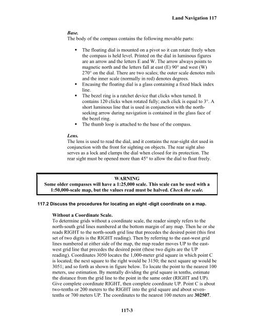
- Page 278 and 279: 117 Land Navigation NOTE: Based on
- Page 280 and 281: 117 Land Navigation the zero-zero p
- Page 282 and 283: 117 Land Navigation o Examine the t
- Page 284 and 285: 117 Land Navigation Bar scale. Thes
- Page 286 and 287: 117 Land Navigation Figure 10-17. H
- Page 288 and 289: 117 Land Navigation Figure 10-20. R
- Page 290 and 291: 117 Land Navigation Cliff A cliff i
- Page 292 and 293: 117 Land Navigation True North. A l
- Page 294 and 295: 117 Land Navigation Figure 6-3. Bac
- Page 296 and 297: 117 Land Navigation from the ending
- Page 298 and 299: 117 Land Navigation Figure 6-9. Dec
- Page 300 and 301: 117 Land Navigation Figure 6-11. Co
- Page 302 and 303: 117 Land Navigation • Convert a m
- Page 304 and 305: 117 Land Navigation • If the magn
- Page 306 and 307: 117 Land Navigation Figure 11-4. Ma
- Page 308 and 309: 117 Land Navigation • Step 4. Sta
- Page 310 and 311: 117 Land Navigation Figure 6-16. In
- Page 312 and 313: 117 Land Navigation map. For greate
- Page 314 and 315: 117 Land Navigation o Convert the g
- Page 316: 117 Land Navigation 117-42


