

St. Charles County Transportation Plan 2030 - East-West Gateway ...
St. Charles County Transportation Plan 2030 - East-West Gateway ...
St. Charles County Transportation Plan 2030 - East-West Gateway ...

Create successful ePaper yourself
Turn your PDF publications into a flip-book with our unique Google optimized e-Paper software.
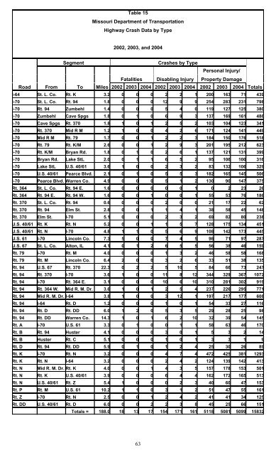
Table 15<br />
Missouri Department of <strong>Transportation</strong><br />
Highway Crash Data by Type<br />
2002, 2003, and 2004<br />
Segment Crashes by Type<br />
Fatalities Disabling Injury<br />
Road From To Miles 2002 2003 2004 2002 2003 2004 2002 2003 2004 Totals<br />
I-64 <strong>St</strong>. L. Co. Rt. K 3.2 0 0 0 2 2 1 200 163 71 439<br />
I-70 <strong>St</strong>. L. Co. Rt. 94 1.8 0 0 0 12 9 9 254 283 231 798<br />
I-70 Rt. 94 Zumbehl 1.4 0 0 0 5 4 0 119 127 125 380<br />
I-70 Zumbehl Cave Spgs 1.8 0 1 0 6 9 3 137 169 161 486<br />
I-70 Cave Spgs Rt. 370 1.8 1 0 1 2 5 2 103 104 123 341<br />
I-70 Rt. 370 Mid R M 1.2 1 0 0 4 2 6 171 124 141 449<br />
I-70 Mid R M Rt. 79 1.7 0 0 1 2 2 3 184 150 176 518<br />
I-70 Rt. 79 Rt. K/M 2.6 0 0 1 2 9 3 201 195 212 623<br />
I-70 Rt. K/M Bryan Rd. 1.8 0 1 0 2 6 1 137 121 131 399<br />
I-70 Bryan Rd. Lake <strong>St</strong>L 2.0 0 1 1 6 5 2 95 106 100 316<br />
I-70 Lake <strong>St</strong>L U.S. 40/61 3.6 1 0 0 2 3 2 83 132 106 329<br />
I-70 U.S. 40/61 Pearce Blvd. 2.1 0 1 0 5 5 3 182 165 145 506<br />
I-70 Pearce Blvd. Warren Co. 4.9 0 0 0 5 1 2 130 90 147 375<br />
Rt. 364 <strong>St</strong>. L. Co. Rt. 94 E. 1.6 0 0 0 0 0 1 0 2 23 26<br />
Rt. 364 Rt. 94 E. Rt. 94 W. 1.6 0 0 1 0 0 1 55 53 76 186<br />
Rt. 370 <strong>St</strong>. L. Co. Rt. 94 0.6 0 0 0 2 0 0 21 17 22 62<br />
Rt. 370 Rt. 94 Elm <strong>St</strong>. 2.8 0 0 1 1 4 1 38 58 45 148<br />
Rt. 370 Elm <strong>St</strong>. I-70 5.1 0 0 0 2 3 2 69 82 80 238<br />
U.S. 40/61 Rt. K Rt. N 5.2 0 0 1 1 5 7 128 175 134 451<br />
U.S. 40/61 Rt. N I-70 4.8 1 1 0 5 6 9 108 142 173 445<br />
U.S. 61 I-70 Lincoln Co. 7.3 5 0 0 7 4 5 98 71 97 287<br />
U.S. 67 <strong>St</strong>. L. Co. Alton, IL 4.1 0 1 2 6 5 5 56 38 46 159<br />
Rt. 79 I-70 Rt. M 4.0 0 0 0 1 3 2 46 58 58 168<br />
Rt. 79 Rt. M Lincoln Co. 6.4 2 0 0 3 2 6 33 51 38 135<br />
Rt. 94 U.S. 67 Rt. 370 22.3 0 2 2 5 10 5 84 66 73 247<br />
Rt. 94 Rt. 370 I-70 3.6 1 0 0 11 8 12 344 329 367 1072<br />
Rt. 94 I-70 Rt. 364 E. 3.1 0 0 0 10 6 10 310 281 302 919<br />
Rt. 94 Rt. 364 W. Mid R. M. Dr. 3.6 1 0 1 2 5 4 237 226 295 771<br />
Rt. 94 Mid R. M. Dr. I-64 3.8 1 0 0 3 12 1 197 217 177 608<br />
Rt. 94 I-64 Rt. D 1.2 0 0 0 1 0 1 54 33 27 116<br />
Rt. 94 Rt. D Rt. DD 6.0 1 2 0 5 3 5 29 28 25 98<br />
Rt. 94 Rt. DD Warren Co. 14.3 1 0 1 6 2 10 32 39 54 145<br />
Rt. A I-70 U.S. 61 3.3 0 1 0 0 1 1 58 63 46 170<br />
Rt. B Rt. 94 Huster 4.1 0 0 0 3 0 1 5 3 2 14<br />
Rt. B Huster Rt. C 5.1 0 0 0 1 0 1 3 3 1 9<br />
Rt. D Rt. 94 Rt. DD 5.9 0 1 0 1 2 4 25 30 26 89<br />
Rt. K I-70 Rt. N 3.2 0 0 0 4 7 4 472 425 381 1293<br />
Rt. K Rt. N I-64 3.2 0 0 0 2 4 2 124 139 142 413<br />
Rt. N Mid R. M. Dr. Rt. K 4.0 0 0 1 4 3 5 157 178 153 501<br />
Rt. N Rt. K U.S. 40/61 3.9 0 0 0 6 4 4 162 172 165 513<br />
Rt. N U.S. 40/61 Rt. Z 5.4 1 0 0 0 2 3 40 60 47 153<br />
Rt. P Rt. M U.S. 61 10.2 1 1 0 3 1 2 51 47 55 161<br />
Rt. Z I-70 Rt. N 2.5 0 0 1 2 4 2 41 41 34 125<br />
Rt. DD U.S. 40/61 Rt. D 6.0 0 0 2 2 3 8 45 25 66 151<br />
Totals = 188.0 18 13 17 154 171 161 5118 5081 5099 15832<br />
63<br />
Personal Injury/<br />
Property Damage


