

Bridging the Gap: linking timber trade with infrastructural ...
Bridging the Gap: linking timber trade with infrastructural ...
Bridging the Gap: linking timber trade with infrastructural ...

Create successful ePaper yourself
Turn your PDF publications into a flip-book with our unique Google optimized e-Paper software.
STUDY AREA OVERVIEW<br />
The study area covered by this project included seven districts belonging to three regions, namely Rufiji<br />
District (Coast Region), Lindi, Kilwa, Liwale, Ruangwa and Nachingwea Districts (Lindi Region), and<br />
Mtwara District (Mtwara Region). The total population in <strong>the</strong> study area was estimated at over 1.3<br />
million people in 2000. Selected social indicators are shown in Table 7. Rural people’s livelihoods are<br />
heavily dependent upon woodland and forest resources in <strong>the</strong> form of food, housing, fuel, medicines and<br />
income. The transport and communications infrastructure are poor in relation to <strong>the</strong> rest of <strong>the</strong> country.<br />
For example, out of a total 5596 km of road networks in Mtwara Region, only 135 km are tarmac. The<br />
study area holds only one major road <strong>linking</strong> to Dar es Salaam, one airport capable of handling large<br />
aircraft, and one marine port capable of handling deep berth cargo. There are no railway networks, and<br />
telecommunication and electricity services are few and unreliable. Major rivers flowing through <strong>the</strong><br />
study area include <strong>the</strong> Mbewekuru, Matandu and Rufiji (Figure 1).<br />
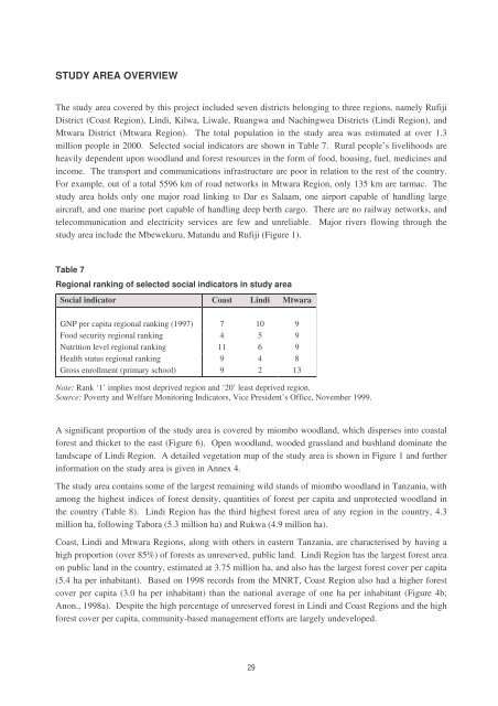
Table 7<br />
Regional ranking of selected social indicators in study area<br />
Social indicator Coast Lindi Mtwara<br />
GNP per capita regional ranking (1997) 7 10 9<br />
Food security regional ranking 4 5 9<br />
Nutrition level regional ranking 11 6 9<br />
Health status regional ranking 9 4 8<br />
Gross enrollment (primary school) 9 2 13<br />
Note: Rank ‘1’ implies most deprived region and ‘20’ least deprived region.<br />
Source: Poverty and Welfare Monitoring Indicators, Vice President’s Office, November 1999.<br />
A significant proportion of <strong>the</strong> study area is covered by miombo woodland, which disperses into coastal<br />
forest and thicket to <strong>the</strong> east (Figure 6). Open woodland, wooded grassland and bushland dominate <strong>the</strong><br />
landscape of Lindi Region. A detailed vegetation map of <strong>the</strong> study area is shown in Figure 1 and fur<strong>the</strong>r<br />
information on <strong>the</strong> study area is given in Annex 4.<br />
The study area contains some of <strong>the</strong> largest remaining wild stands of miombo woodland in Tanzania, <strong>with</strong><br />
among <strong>the</strong> highest indices of forest density, quantities of forest per capita and unprotected woodland in<br />
<strong>the</strong> country (Table 8). Lindi Region has <strong>the</strong> third highest forest area of any region in <strong>the</strong> country, 4.3<br />
million ha, following Tabora (5.3 million ha) and Rukwa (4.9 million ha).<br />
Coast, Lindi and Mtwara Regions, along <strong>with</strong> o<strong>the</strong>rs in eastern Tanzania, are characterised by having a<br />
high proportion (over 85%) of forests as unreserved, public land. Lindi Region has <strong>the</strong> largest forest area<br />
on public land in <strong>the</strong> country, estimated at 3.75 million ha, and also has <strong>the</strong> largest forest cover per capita<br />
(5.4 ha per inhabitant). Based on 1998 records from <strong>the</strong> MNRT, Coast Region also had a higher forest<br />
cover per capita (3.0 ha per inhabitant) than <strong>the</strong> national average of one ha per inhabitant (Figure 4b;<br />
Anon., 1998a). Despite <strong>the</strong> high percentage of unreserved forest in Lindi and Coast Regions and <strong>the</strong> high<br />
forest cover per capita, community-based management efforts are largely undeveloped.<br />
29


