Route 132 Corridor Report - Cape Cod Commission
Route 132 Corridor Report - Cape Cod Commission
Route 132 Corridor Report - Cape Cod Commission

You also want an ePaper? Increase the reach of your titles
YUMPU automatically turns print PDFs into web optimized ePapers that Google loves.
D. DESIGN GUIDELINES: AREA B – <strong>Route</strong> <strong>132</strong> Center<br />
Design Guidelines for this area of <strong>Route</strong> <strong>132</strong>, stretching from Independence<br />
Drive to the eastern side of <strong>Cape</strong> <strong>Cod</strong> Mall/Kmart Plaza, reinforce<br />
the more open feeling of deep vegetated buffers and development set well<br />
back from the roadway. Open space beginning to the east of Border’s,<br />
heavy landscaping around Sam Diego’s restaurant, and open space on the<br />
northeast and southeast corners of the intersection with Independence<br />
Drive mark a clear transition to a more vegetated and open character of<br />
development. This open character needs to be carried across the frontage<br />
of the regional malls with much deeper and more varied landscape buffers.<br />
The mall buildings and circulation patterns for pedestrians and cars<br />
should be focused on the interior of these sites, with structures approaching<br />
<strong>Route</strong> <strong>132</strong> only at key pedestrian intersections. Additional commercial<br />
and mixed use development can be accommodated in neighborhood<br />
scale structures along these internal road networks. The roadway median<br />
in this area should support this green character with plantings or be<br />
treated with a unique surface pattern to make it a visual asset.<br />
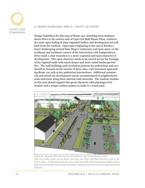
Figure K: Proposed Development in Area B/<strong>Route</strong> <strong>132</strong> Center (facing north)<br />
This view looks north, across <strong>Route</strong> <strong>132</strong>, from the <strong>Cape</strong> <strong>Cod</strong> Mall entrance road to the<br />
Kmart Plaza. It illustrates how the area could look with wider landscaped buffers along<br />
<strong>Route</strong> <strong>132</strong> and additional frontage buildings oriented toward the internal pedestrian/road<br />
network.<br />
62<br />
september 2010 | route <strong>132</strong> corridor <strong>Report</strong>