Route 132 Corridor Report - Cape Cod Commission
Route 132 Corridor Report - Cape Cod Commission
Route 132 Corridor Report - Cape Cod Commission

You also want an ePaper? Increase the reach of your titles
YUMPU automatically turns print PDFs into web optimized ePapers that Google loves.
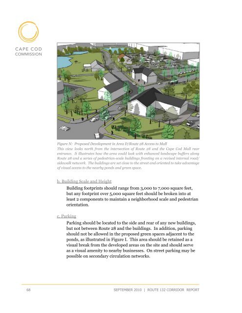
Figure N: Proposed Development in Area D/<strong>Route</strong> 28 Access to Mall<br />
This view looks north from the intersection of <strong>Route</strong> 28 and the <strong>Cape</strong> <strong>Cod</strong> Mall rear<br />
entrance. It illustrates how the area could look with enhanced landscape buffers along<br />
<strong>Route</strong> 28 and a series of pedestrian-scale buildings fronting on a revised internal road/<br />
sidewalk network. The buildings are set close to the street and oriented to take advantage<br />
of visual access to the nearby ponds and green space.<br />
b. Building Scale and Height<br />
Building footprints should range from 3,000 to 7,000 square feet,<br />
but any footprint over 5,000 square feet should be broken into at<br />
least 2 components to maintain a neighborhood scale and pedestrian<br />
orientation.<br />
c. Parking<br />
Parking should be located to the side and rear of any new buildings,<br />
but not between <strong>Route</strong> 28 and the buildings. In addition, parking<br />
should not be allowed in the proposed green spaces adjacent to the<br />
ponds, as illustrated in Figure I. This area should be retained as a<br />
visual break from the developed areas on the site and should serve<br />
as a visual amenity to nearby businesses. On street parking may be<br />
possible on secondary circulation networks.<br />
68<br />
september 2010 | route <strong>132</strong> corridor <strong>Report</strong>