chapter - 1 introduction - Meghalaya State Pollution Control Board
chapter - 1 introduction - Meghalaya State Pollution Control Board
chapter - 1 introduction - Meghalaya State Pollution Control Board

Create successful ePaper yourself
Turn your PDF publications into a flip-book with our unique Google optimized e-Paper software.
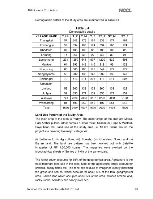
Hills Cement Co. Limited.<br />
Demographic details of the study area are summarized in Table 3.4<br />
<br />
Table 3.4<br />
Demographic details<br />
VILLAGE NAME T_HH T_P T_M T_F ST_P ST_M ST_F<br />
Thangskai 57 342 178 164 338 174 164<br />
Umshangiar 59 334 160 174 334 160 174<br />
Khaddum 37 188 103 85 188 103 85<br />
Larseng 14 83 56 27 53 32 21<br />
Lumshnong 231 1250 643 607 1230 632 598<br />
Mynkre 64 293 148 145 219 96 123<br />
Nongsning 65 365 185 180 344 172 172<br />
Nongthymme 50 282 135 147 282 135 147<br />
Shiehruphi 73 416 211 205 416 211 205<br />
Umbadoh - - - - - - -<br />
Umlong 52 260 138 122 260 138 122<br />
Umtyra 59 330 171 159 330 171 159<br />
Wahiajer 741 4295 2088 2207 4278 2080 2198<br />
Wahsarang 81 498 252 246 497 251 246<br />
<br />
Total 1630 9197 4607 4590 9030 4494 4536<br />
Land Use Pattern of the Study Area<br />
The main crop of the area is Paddy. The minor crops of the area are Maize,<br />
Rabi &other pulses, Other cereals & small millet, Sesamum, Rape & Mustard,<br />
Soya bean etc. Land use of the study area i.e. 10 km radius around the<br />
project site covering five major categories:<br />
(i) Settlement, (ii) Agriculture, (iii) Forests, (iv) Grassland Scrub and (v)<br />
Barren land. The land use pattern has been worked out with Satellite<br />
Imageries of RF 1:50,000 scales. The imageries were overlaid on the<br />
topographical sheets of Survey of India of the same scale.<br />
The forest cover accounts for 69% of the geographical area. Agriculture is the<br />
next important land use in the area. Most of the agricultural lands account for<br />
orchard, paddy fields etc. The tone and texture of imageries clearly identified<br />
the grass and scrubs, which account for about 6% of the total geographical<br />
area. Barren land which occupies about 5% of the area includes broken land,<br />
rocky knobs, boulders and sandy river bed.<br />
<strong>Pollution</strong> <strong>Control</strong> Consultants (India) Pvt. Ltd. 40
![[FORM I] - Meghalaya State Pollution Control Board](https://img.yumpu.com/49771786/1/190x245/form-i-meghalaya-state-pollution-control-board.jpg?quality=85)