- Page 1:
CHESAPEAKE COLLEGEFacilities Master
- Page 4 and 5:
Chesapeake College January 2012 Fac
- Page 7:
TABLE OF CONTENTSChapter 1………
- Page 11 and 12:
Chesapeake College January 2012 Fac
- Page 13 and 14:
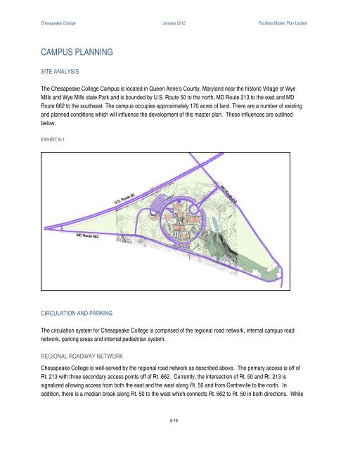
Chesapeake College January 2012 Fac
- Page 15:
Chesapeake College January 2012 Fac
- Page 18 and 19:
Chesapeake College January 2012 Fac
- Page 20 and 21:
Chesapeake College January 2012 Fac
- Page 22 and 23:
Chesapeake College January 2012 Fac
- Page 24 and 25:
Chesapeake College January 2012 Fac
- Page 27:
Chapter 3ACADEMIC PROGRAMS AND SPAC
- Page 30 and 31:
Chesapeake College January 2012 Fac
- Page 32 and 33:
Chesapeake College January 2012 Fac
- Page 34 and 35:
Chesapeake College January 2012 Fac
- Page 36 and 37:
Chesapeake College January 2012 Fac
- Page 38 and 39:
Chesapeake College January 2012 Fac
- Page 40 and 41:
Chesapeake College January 2012 Fac
- Page 42 and 43:
Chesapeake College January 2012 Fac
- Page 44 and 45:
Chesapeake College January 2012 Fac
- Page 46 and 47:
Chesapeake College January 2012 Fac
- Page 48 and 49:
Chesapeake College January 2012 Fac
- Page 50 and 51:
Chesapeake College January 2012 Fac
- Page 52 and 53:
Chesapeake College January 2012 Fac
- Page 54 and 55:
Chesapeake College January 2012 Fac
- Page 57:
Chapter 4WYE MILLS CAMPUS FACILITIE
- Page 60 and 61:
Chesapeake College January 2012 Fac
- Page 62 and 63:
Chesapeake College January 2012 Fac
- Page 64 and 65:
Chesapeake College January 2012 Fac
- Page 66 and 67:
Chesapeake College January 2012 Fac
- Page 68 and 69:
Chesapeake College January 2012 Fac
- Page 70 and 71:
Chesapeake College January 2012 Fac
- Page 72 and 73:
Chesapeake College January 2012 Fac
- Page 74 and 75:
Chesapeake College January 2012 Fac
- Page 76 and 77:
Chesapeake College January 2012 Fac
- Page 78 and 79:
Chesapeake College January 2012 Fac
- Page 80 and 81:
Chesapeake College January 2012 Fac
- Page 82 and 83:
Chesapeake College January 2012 Fac
- Page 84 and 85: Chesapeake College January 2012 Fac
- Page 86 and 87: Chesapeake College January 2012 Fac
- Page 88 and 89: Chesapeake College January 2012 Fac
- Page 90 and 91: Chesapeake College January 2012 Fac
- Page 92 and 93: Chesapeake College January 2012 Fac
- Page 94 and 95: Chesapeake College January 2012 Fac
- Page 96 and 97: Chesapeake College January 2012 Fac
- Page 98 and 99: Chesapeake College January 2012 Fac
- Page 100 and 101: Chesapeake College January 2012 Fac
- Page 102 and 103: Chesapeake College January 2012 Fac
- Page 105 and 106: Chesapeake College January 2012 Fac
- Page 107 and 108: Chesapeake College January 2012 Fac
- Page 109 and 110: Chesapeake College January 2012 Fac
- Page 111 and 112: Chesapeake College January 2012 Fac
- Page 113 and 114: Chesapeake College January 2012 Fac
- Page 115: Chesapeake College January 2012 Fac
- Page 119 and 120: Chesapeake College January 2012 Fac
- Page 121 and 122: Chesapeake College January 2012 Fac
- Page 123 and 124: Chesapeake College January 2012 Fac
- Page 125 and 126: Chesapeake College January 2012 Fac
- Page 127 and 128: Chesapeake College January 2012 Fac
- Page 129 and 130: Chesapeake College January 2012 Fac
- Page 131 and 132: Chesapeake College January 2012 Fac
- Page 133: Chesapeake College January 2012 Fac
- Page 137 and 138: Chesapeake College January 2012 Fac
- Page 139 and 140: Chesapeake College January 2012 Fac
- Page 141 and 142: Chesapeake College January 2012 Fac
- Page 143 and 144: Chesapeake College January 2012 Fac
- Page 145 and 146: Chesapeake College January 2012 Fac
- Page 147 and 148: Chesapeake College January 2012 Fac
- Page 149 and 150: Chesapeake College January 2012 Fac
- Page 151 and 152: Chesapeake College January 2012 Fac
- Page 153: Chesapeake College January 2012 Fac
- Page 157 and 158: Chesapeake College January 2012 Fac
- Page 159 and 160: Chesapeake College January 2012 Fac
- Page 161 and 162: Chesapeake College January 2012 Fac
- Page 163: Chesapeake College January 2012 Fac
- Page 167 and 168: Chesapeake College January 2012 Fac
- Page 169: Chesapeake College January 2012 Fac
- Page 173 and 174: To insure that we achieve each of t
- Page 175 and 176: . The College operates its faciliti
- Page 177 and 178: Goal 6: Use transparent, inclusive
- Page 179 and 180: c. Sustainability advocates will me
- Page 181 and 182: Goal 4: Offer learning opportunitie