WEST KIMBERLEY PLACE REPORT - Department of Sustainability ...
WEST KIMBERLEY PLACE REPORT - Department of Sustainability ...
WEST KIMBERLEY PLACE REPORT - Department of Sustainability ...

Create successful ePaper yourself
Turn your PDF publications into a flip-book with our unique Google optimized e-Paper software.
<strong>of</strong> Important Wetlands <strong>of</strong> Australia (Sutton 1998; A. Poelina pers. comm. 2010).<br />
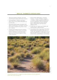
North <strong>of</strong> the Fitzroy River, alluvial plains are bounded by the ranges <strong>of</strong> the Devonian<br />
reef. These black soil plains support grasslands, with scattered trees and shrubs. To<br />
the south, the floodplain abuts the Great Sandy Desert. The dune vegetation <strong>of</strong> the<br />
Great Sandy Desert is simple in species and structure. The sides <strong>of</strong> dunes sometimes<br />
support thick growth <strong>of</strong> hummock grass (Plectrachne schinzii) and scattered shrubs,<br />
but the crests are kept bare by the harsh climate and the action <strong>of</strong> the wind.<br />
Traditional Owners relied on their detailed and intimate knowledge <strong>of</strong> the availability<br />
<strong>of</strong> permanent and seasonal water sources to survive here; these water sources have<br />
been used for generations. Freshwater soaks and springs hold intense spiritual<br />
significance for desert people, and these water sources also have high biodiversity<br />
values. Each place where water can be found is individually named and known, and<br />
has many stories associated with it, although some <strong>of</strong> these stories may be secret or<br />
culturally restricted. Permanent water sources are called 'jila' and are all connected<br />
through the underlying groundwater system, which is known as kurtany, or mother.<br />
Through performing their obligations, Traditional Owners maintain the water levels<br />
(WWF–Australia 2007; Yu 2000).<br />
CONTACT HISTORY<br />
Although permanent European settlement occurred later in the Kimberley than in<br />
most other parts <strong>of</strong> Australia, the coastline was the site <strong>of</strong> sporadic contact between<br />
Aboriginal people and outsiders since at least the sixteenth century. The region's<br />
recent history has been shaped by the ambitions and fears, curiosity, hope and needs<br />
<strong>of</strong> these diverse newcomers; as well as by the broader political and economic<br />
circumstances which led them to the region, and the institutional structures they<br />
imported or created. Central to the post-contact history <strong>of</strong> the Kimberley has been the<br />
capacity <strong>of</strong> Kimberley Aboriginal people to resist, adapt to and survive the changes<br />
outsiders have brought.<br />
From the 1870s, Aboriginal people have been coerced or forced into the pastoral and<br />
pearling industries, and institutionalized in missions, prisons, hospitals, ration depots<br />
and reserves. Colonisation has had a severe impact on the lives <strong>of</strong> Kimberley<br />
Aboriginal people and forced dramatic changes to traditional ways <strong>of</strong> life - many lost<br />
their lives or were dispossessed <strong>of</strong> their country and homelands. But throughout the<br />
intense disruption wrought by colonisation, over time Aboriginal people have devised<br />
strategies that have enabled an accommodation with the new regime and which has<br />
ensured their long-term survival as a distinct and proud people. The effectiveness <strong>of</strong><br />
these strategies is demonstrated by the success in the Federal Court <strong>of</strong> Australia <strong>of</strong><br />
fourteen applications for the determination <strong>of</strong> native title throughout the Kimberley<br />
since the passage <strong>of</strong> the Native Title Act in 1993 (Jebb and Allbrook 2009).<br />
The southernmost shore<br />
Before European settlement, Australia's north coast was the southernmost shore <strong>of</strong> a<br />
network <strong>of</strong> trade and travel which connected south-east Asia with the marketplaces <strong>of</strong><br />
China. The Kimberley lies within 400 kilometres <strong>of</strong> the south-eastern limit <strong>of</strong> the<br />
Indonesian Archipelago. For perhaps hundreds <strong>of</strong> years, Indonesians came to Kayu<br />
35