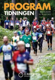
Programme O-Ringen Värmland 2017

Create successful ePaper yourself
Turn your PDF publications into a flip-book with our unique Google optimized e-Paper software.
PROGRAMME O-RINGEN VÄRMLAND <strong>2017</strong><br />
15<br />
Training race and training areas<br />
There are a number of opportunities<br />
available to train and sharpen<br />
the skills you will need in the challenging<br />
terrain found in <strong>Värmland</strong>.<br />
There are several maps to choose<br />
from, as well as a training race that<br />
will take place just before O-<strong>Ringen</strong>’s<br />
start.<br />
Training race<br />
The race will take place Friday, July 21 with<br />
open start time between 2-5pm. Pre-register<br />
through oringen.se. You can also register at<br />
Competitor Services at O-<strong>Ringen</strong> City or at the<br />
training race arena, which is located in Stålsberga<br />
about 2km north of O-<strong>Ringen</strong> City. Direction<br />
sides for walking/biking start at O-<strong>Ringen</strong><br />
Square. Very limited parking possibilities<br />
are available for cars. Additional information<br />
can be found on oringen.se.<br />
Courses<br />
Difficulty Scale Length (km)<br />
Very easy 1:10 000 1.5<br />
Easy 2 1:10 000 2.4<br />
Easy 4 1:10 000 3.5<br />
Medium 3 1:10 000 3.1<br />
Medium 4 1:10 000 4.0<br />
Medium 5 1:10 000 4.9<br />
Difficult 3 1:10 000 3.1<br />
Difficult 5 1:10 000 5.0<br />
Difficult 7.5 1:10 000 7.2<br />
Services<br />
Bicycle parking and toilets adjacent to the<br />
training race arena. Very limited car parking.<br />
Terrain<br />
The area is typical of western <strong>Värmland</strong> and features<br />
three large hills. The shorter courses (those<br />
up to 3.5km) will only visit one of them. The area<br />
has a relatively well-developed trail network and<br />
a number of other large features. Climb is moderate<br />
to steep, and runnability is mostly good.<br />
Map<br />
Scale 1:10000 with 5m contour interval<br />
Start<br />
It is easiest to get to Stålsberga by foot or bicycle.<br />
From the northern part of O-<strong>Ringen</strong> City it<br />
is only 1.5km. Registration, start, and finish are<br />
located at the same spot.<br />
Do you want to take a chance<br />
to try out other disciplines of<br />
orienteering?<br />
On Activity Day, Tuesday, July 25, you can test<br />
out MtbO or Trail-O. Or maybe both? See additional<br />
information under each discipline’s<br />
respective information documents.You can<br />
sign up through oringen.se, by clicking on the<br />
menu “Activities”.<br />
Training maps<br />
We offer 4 different training areas for orienteering<br />
and one for MtbO. The maps are printed<br />
with all control locations and with suggested<br />
courses corresponding to different lengths<br />
and difficulty levels.<br />
Maps can be purchased through the registration<br />
portal at oringen.se or at Competitor<br />
Services at O-<strong>Ringen</strong> City. Controls are out in<br />
the forest for varying durations of time, depending<br />
on the specific map, but the longest<br />
is from May 1 to September 30. Purchased<br />
maps can be picked up at Competitor Services.<br />
If you would like to receive them by mail<br />
earlier, send an email with your request to<br />
info@oringen.se.<br />
Controls are marked with poles with letter<br />
codes that can be registered in the mobile app<br />
“Stolpjakten” or at oringen.stolpjakten.se.<br />
Training areas for orienteering<br />
1. Karsbol: 30 controls of varying degrees of difficulty.<br />
The terrain is most relevant for stages 1<br />
and 2. Parking in central Fagerås. From there,<br />
800m to the start of the training courses.<br />
2. Koppom: 27 controls of varying degrees of<br />
difficult. This area is adjacent to the maps<br />
used for stages 3 and 4. Parking at Koppom’s<br />
sports hall, which is also the start location<br />
for the training courses.<br />
3. Taserud: 31 controls of varying degrees of<br />
difficulty. The area is adjacent to the west<br />
side of O-<strong>Ringen</strong> City, and the trail-rich terrain<br />
is most similar to that of the final stage.<br />
Parking at O-<strong>Ringen</strong> City’s visitor parking.<br />
4. Kil (sprint map), map released July 19. This is a<br />
good option for those who want to train for<br />
sprint races. Parking at the Kil train station.<br />
MtbO Training Map<br />
Two training courses are available: Vik/<br />
Styckåsen and Ingestrand. Both maps are<br />
released on July 19. Both areas are located<br />
3-5km south of O-<strong>Ringen</strong> City and are printed<br />
on the same map.<br />
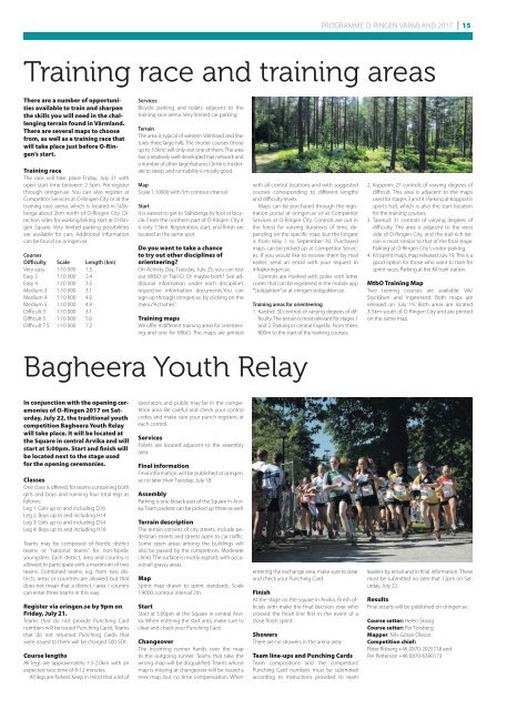
Bagheera Youth Relay<br />
In conjunction with the opening ceremonies<br />
of O-<strong>Ringen</strong> <strong>2017</strong> on Saturday,<br />
July 22, the traditional youth<br />
competition Bagheera Youth Relay<br />
will take place. It will be located at<br />
the Square in central Arvika and will<br />
start at 5:00pm. Start and finish will<br />
be located next to the stage used<br />
for the opening ceremonies.<br />
Classes<br />
One class is offered, for teams containing both<br />
girls and boys and running four total legs as<br />
follows:<br />
Leg 1: Girls up to and including D16<br />
Leg 2: Boys up to and including H14<br />
Leg 3: Girls up to and including D14<br />
Leg 4: Boys up to and including H16<br />
Teams may be composed of Nordic district<br />
teams or “national teams” for non-Nordic<br />
youngsters. Each district, area and country is<br />
allowed to participate with a maximum of two<br />
teams. Combined teams, e.g. from two districts,<br />
areas or countries are allowed, but that<br />
does not mean that a district / area / country<br />
can enter three teams in this way.<br />
Register via oringen.se by 9pm on<br />
Friday, July 21.<br />
Teams that do not provide Punching Card<br />
numbers will be issued Punching Cards. Teams<br />
that do not returned Punching Cards that<br />
were issued to them will be charged 500 SEK.<br />
Course lengths<br />
All legs are approximately 1.5-2.0km with an<br />
expected race time of 8-12 minutes.<br />
All legs are forked. Keep in mind that a lot of<br />
spectators and public may be in the competition<br />
area. Be careful and check your control<br />
codes and make sure your punch registers at<br />
each control.<br />
Services<br />
Toilets are located adjacent to the assembly<br />
area.<br />
Final information<br />
Final information will be published at oringen.<br />
se no later than Tuesday, July 18.<br />
Assembly<br />
Parking is one bloack east of the Square in Arvika.<br />
Team packets can be picked up there as well.<br />
Terrain description<br />
The terrain consists of city streets, include pedestrian<br />
streets and streets open to car traffic.<br />
Some open areas among the buildings will<br />
also be passed by the competitors. Moderate<br />
climb. The surface is mostly asphalt, with occasionall<br />
grassy areas.<br />
Map<br />
Sprint map drawn to sprint standards. Scale<br />
1:4000, contour interval 2m.<br />
Start<br />
Start at 5:00pm at the Square in central Arvika.<br />
When entering the start area, make sure to<br />
clear and check your Punching Card.<br />
Changeover<br />
The incoming runner hands over the map<br />
to the outgoing runner. Teams that take the<br />
wrong map will be disqualified. Teams whose<br />
map is missing at changeover will be issued a<br />
new map, but no time compensation. When<br />
entering the exchange area, make sure to clear<br />
and check your Punching Card.<br />
Finish<br />
At the stage on the square in Arvika. Finish officials<br />
with make the final decision over who<br />
crossed the finish line first in the event of a<br />
close finish sprint.<br />
Showers<br />
There are no showers in the arena area.<br />
Team line-ups and Punching Cards<br />
Team compositions and the competitors’<br />
Punching Card numbers must be submitted<br />
according to instructions provided to team<br />
leaders by email and in final information. These<br />
must be submitted no later that 12pm on Saturday,<br />
July 22.<br />
Results<br />
Final results will be published on oringen.se.<br />
Course setter: Helen Skoog<br />
Course setter: Per Forsberg<br />
Mapper: Nils-Göran Olsson<br />
Competition chief:<br />
Peter Risberg +46 (0)70-2925718 and<br />
Per Petterson +46 (0)70-6390173