Programme O-Ringen Värmland 2017

Create successful ePaper yourself
Turn your PDF publications into a flip-book with our unique Google optimized e-Paper software.
PROGRAMME O-RINGEN VÄRMLAND <strong>2017</strong><br />
21<br />
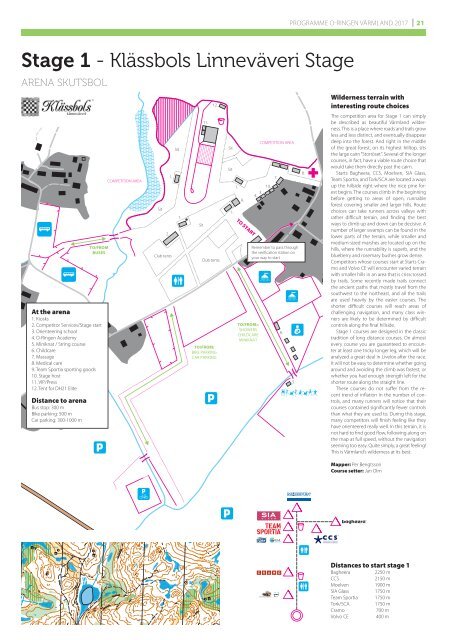
Stage 1 - Klässbols Linneväveri Stage<br />
ARENA SKUTSBOL<br />
TO/FROM<br />
BUSES<br />
At the arena<br />
1. Kiosks<br />
2. Competitor Services/Stage start<br />
3. Orienteering school<br />
4. O-<strong>Ringen</strong> Academy<br />
5. Miniknat / String course<br />
6. Childcare<br />
7. Massage<br />
8. Medical care<br />
9. Team Sportia sporting goods<br />
10. Stage host<br />
11. VIP/Press<br />
12. Tent for DH21 Elite<br />
Distance to arena<br />
Bus stop: 300 m<br />
Bike parking: 500 m<br />
Car parking: 300-1000 m<br />
COMPETITION AREA<br />
Sit<br />
2.<br />
1.<br />
Club tents<br />
Sit<br />
1.<br />
Sit<br />
11.<br />
12.<br />
Club tents<br />
TO/FROM:<br />
BIKE PARKING<br />
CAR PARKING<br />
Sit<br />
Sit<br />
1.<br />
1.<br />
9.<br />
TO START<br />
TO/FROM::<br />
SHOWERS<br />
CHILDCARE<br />
MINIKNAT<br />
COMPETITION AREA<br />
10.<br />
3.<br />
4.<br />
7.<br />
Remember to pass through<br />
the verification station on<br />
your way to start<br />
6.<br />
5.<br />
8.<br />
Wilderness terrain with<br />
interesting route choices<br />
The competition area for Stage 1 can simply<br />
be described as beautiful <strong>Värmland</strong> wilderness.<br />
This is a place where roads and trails grow<br />
less and less distinct, and eventually disappear<br />
deep into the forest. And right in the middle<br />
of the great forest, on its highest hilltop, sits<br />
the large cairn “Storröset”. Several of the longer<br />
courses, in fact, have a viable route choice that<br />
would take them directly past the cairn.<br />
Starts Bagheera, CCS, Moelven, SIA Glass,<br />
Team Sportia, and Tork/SCA are located a ways<br />
up the hillside right where the nice pine forest<br />
begins. The courses climb in the beginning<br />
before getting to areas of open, runnable<br />
forest covering smaller and larger hills. Route<br />
choices can take runners across valleys with<br />
rather difficult terrain, and finding the best<br />
ways to climb up and down can be decisive. A<br />
number of larger swamps can be found in the<br />
lower parts of the terrain, while smaller and<br />
medium-sized marshes are located up on the<br />
hills, where the runnability is superb, and the<br />
blueberry and rosemary bushes grow dense.<br />
Competitors whose courses start at Starts Cramo<br />
and Volvo CE will encounter varied terrain<br />
with smaller hills in an area that is crisscrossed<br />
by trails. Some recently made trails connect<br />
the ancient paths that mostly travel from the<br />
southwest to the northeast, and all the trails<br />
are used heavily by the easier courses. The<br />
shorter difficult courses will reach areas of<br />
challenging navigation, and many class winners<br />
are likely to be determined by difficult<br />
controls along the final hillside.<br />
Stage 1 courses are designed in the classic<br />
tradition of long distance courses. On almost<br />
every course you are guaranteed to encounter<br />
at least one tricky longer leg, which will be<br />
analyzed a great deal in Livelox after the race.<br />
It will not be easy to determine whether going<br />
around and avoiding the climb was fastest, or<br />
whether you had enough strength left for the<br />
shorter route along the straight line.<br />
These courses do not suffer from the recent<br />
trend of inflation in the number of controls,<br />
and many runners will notice that their<br />
courses contained significantly fewer controls<br />
than what they are used to. During this stage,<br />
many competitors will finish feeling like they<br />
have orienteered really well. In this terrain, it is<br />
not hard to find good flow, following along on<br />
the map at full speed, without the navigation<br />
seeming too easy. Quite simply, a great feeling!<br />
This is <strong>Värmland</strong>’s wilderness at its best.<br />
Mapper: Per Bengtsson<br />
Course setter: Jan Olm<br />
Distances to start stage 1<br />
Bagheera<br />
CCS<br />
Moelven<br />
SIA Glass<br />
Team Sportia<br />
Tork/SCA<br />
Cramo<br />
Volvo CE<br />
2250 m<br />
2150 m<br />
1900 m<br />
1750 m<br />
1750 m<br />
1750 m<br />
700 m<br />
400 m