concept EIA-rapport - Staatsolie
concept EIA-rapport - Staatsolie
concept EIA-rapport - Staatsolie
You also want an ePaper? Increase the reach of your titles
YUMPU automatically turns print PDFs into web optimized ePapers that Google loves.
SRK Consulting: Project No: 439414 <strong>Staatsolie</strong> Pipeline <strong>EIA</strong> – Draft <strong>EIA</strong> Report Page 22<br />
4 Description of the affected environment<br />
The area in which the pipeline corridor is located has been developed for over 300 years. Oilrelated<br />
activities have taken place at the <strong>Staatsolie</strong> refinery site since 1988, and the current<br />
refinery came into operation in 1997. The corridor is situated in a peri-urban and industrial<br />
area.<br />
Although project activities will be largely restricted to drill pads and a narrow strip along the<br />
assembly and launching areas, a wider area has been described to present the pipeline<br />
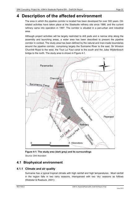
corridor in context. The study area has been defined by the natural and man-made boundaries<br />
around the pipeline corridor, comprising largely the Suriname River to the east, Sir Winston<br />
Churchill Road to the west, the Tout Lui Faut canal to the south and the Jules Wijdenbosch<br />
bridge to the north. The study area is shown in Figure 4-1.<br />
Figure 4-1: The study area (dark grey) and its surroundings<br />
Source: Dirk Noordam<br />
4.1 Biophysical environment<br />
4.1.1 Climate and air quality<br />
Suriname has a typical tropical climate with high rainfall and high temperatures. Most rainfall<br />
in the region falls in two rainy seasons, interspersed with two ‘dry’ seasons as follows<br />
(Webster & Roebuck, 2001):<br />
REUT/DALC 439414_<strong>Staatsolie</strong>Pipeline<strong>EIA</strong>_Draft <strong>EIA</strong> Report_Final<br />
June 2012


